
Monastic network of Évora
an architectural route betweent the city and the wilderness
Guidance
Maria do Céu Tereno
António Borges Abel
an architectural route betweent the city and the wilderness
UNIVERSITY OF ÉVORA
INTEGRATED MASTER | DISSERTATION
Guidance
Maria do Céu Tereno
António Borges Abel
Évora | 2019

Abstract
The city of Évora

The city of Évora is the main urban center of Alto Alentejo. Classified by UNESCO as a World Heritage Site since 1986, Évora is the result of a legacy of people and cultures that have inhabited it and contributed to a monumental urban unity.
Its geographical centrality as well as the natural conditions of the surrounding region were decisive for the fixation, permanence and development of these same peoples and cultures over time.
Hinged between the Alentejo coast and the Spanish border, Évora served as a mandatory crossing point between major urban centers. The city is located on a hill overlooking the surrounding landscape. In addition to its strategic location as a "road node", its fertile perimeter allowed the development of an agro-silvo-pastoral economy.
Hinged between the Alentejo coast and the Spanish border, Évora served as a mandatory crossing point between major urban centers. The city is located on a hill overlooking the surrounding landscape. In addition to its strategic location as a "road node", its fertile perimeter allowed the development of an agro-silvo-pastoral economy.


The morphological evolution of Évora: roman city | muslim city | medieval city | middle age | modern age | contemporary age
The monastic network

The network consists of 21 monasteries: 13 intramural monasteries and 8 extramural monasteries.
The monastic settlements, some of which were more prone to the development of agriculture and settlement of the countryside, and others more oriented to the urban environment, were strong influences both in the occupation of the territory and fundamental in the expansion and consolidation of the urban structure.
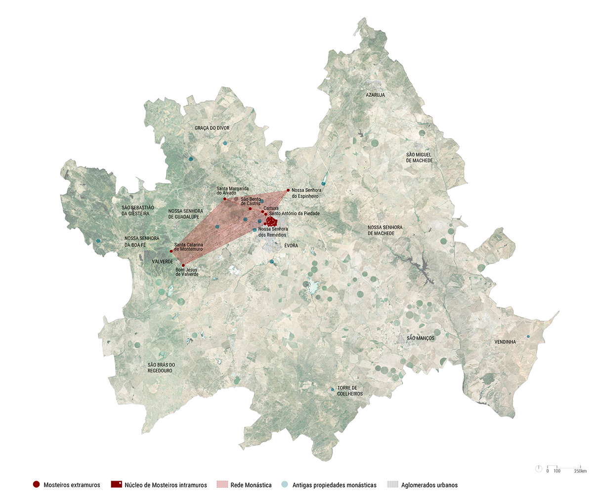
In this way, the "drawing" of the monastic network of Évora is configured between the Christian Reconquest of the city (1165) and the extinction of the Religious Orders (1834), and its scale is divided into three moments: the urban scale (intramural), the peri-urban scale (extramural) and the territorial scale.

The monastic route

The proposed route, with an extension of approximately 60km is divided into two moments:
intramural route: made in the city through the main arteries revealing the intramural monasteries.
extramural route: it advances to periurban and rural areas in order to contemplate the monasteries of the wilderness through several possibilities of route.
The strategy of the proposal is based on the creation of a route, to connect all the monasteries, that is intervened in order to intensify the experience of the visitors.
THE TOWER

The proposal for Alto de São Bento materializes in a tower that rises above the treetops and allows a greater visual amplitude along with the observation of a large part of the monastic ensembles. It is also the evocation of a lost memory: the demolished moorish tower that existed in this place.
The architecture of the tower tries to evoke some characteristics of the monasteries. Its verticality, which refers to the bell towers / viewpoints of the churches of the old convents and its central emptiness, summons the introspection of the cloisters, through simple lines and simple materialities.
The route is guided by walls that draw the entrances and receive the visitors to different levels, while the tower looks for the orientation of the city. These two elements give a dynamic twist in their ascending path to the roof, where they live the high point of the experience. During the ascent, they appear ripped vines that contemplate landscape to different dimensions, breaking the monotony.
Its materiality consists of the use of concrete, whose chromatic melts in the granite landscape, allowing the intervention to age alongside the surrounding.

site plan | axonometric views

plans and section | photo montages

1:200 model
THE SHELTER

The proposal for Vale do Aivado materializes in a shelter for the walker, offering a point of pause and contemplation on the surroundings. This point aims to mark not only the arrival at Santa Margarida do Aivado, but also the presence of vestiges of the old medieval road to Montemor / Lisboa.
The proposal materializes in a monolithic form of concrete, with the aim of marking the place and aging with the landscape. Although abroad is presented in a minimalist way, its interior is, however, more complex, not exposing immediately the spatiality that awaits the visitor. When the visitor gets to the shelter, a covered but outside space with a reduced height, welcomes you with a small tank of water. A bench facing the lake invites you to rest, to contemplation and simultaneously to enter in the last moment of the small building. Inspired by the vernacular architectures of rural chapels, fountains and fresh spaces of the region, there is an introspective space of double height and enclosed by a dome. It is intended to create a fresh retreat for the hot days and simultaneously a space of fire for the cold days, illuminated by a lantern that works in parallel as a chimney. The space in the form of a half circle, brings your visitors together in an environment of comfort and protection.

site plan | axonometric views

plan and section | photo montage

1:200 model
THE VIEWPOINT

The proposal for Castelo do Giraldo seeks to take advantage of the characteristics of the place, through a platform of observation that allows to extend the limit achievable by the visitors, opening up even more the field of vision. The intervention intends to be restrained, respecting the archaeological wealth of the place.
The proposal then functions as a wooden platform that forms a path, bypassing the archaeological fortification and ending at a belvedere. The existing vegetation also absorbs the intervention, providing fresh and shady spaces and making the place inviting.

site plan | axonometric views

plan and section | photo montage

1:200 model

territorial model
drone filming: Francisco Brito
full dissertation: http://dspace.uevora.pt/rdpc/handle/10174/25734

