Activating the ground:
Interface between the contemporary city and the legacy of the building boom
Interface between the contemporary city and the legacy of the building boom

City of Milan
Master plan approved in 1953


The 1940s were a period of great upheaval in Milan. First there was the war, especially the air raids of 1943, which destroyed large areas of the city including some its central and representative buildings and influenced patterns of reconstruction. Then the drafting of new planning instruments, both partial and comprehensive, went on without a break, largely as a result of the approval of 1942 of the first coherent master plan for an Italian city. The new policy laid down that the whole municipal territory should be subject to regulation under a single plan, including consultation with major neighbouring municipalities; it defined the general objectives of the patterns of new development and specified land use on the new Functionalist principles. Application of the Albertini plan in the late thirties had already caused controversy and encountered technical and administrative problems, so it was first re-examined in relation to the most problematic zones and then comprehensively overhauled. Between 1938 and the early 1940s variants and detailed plans were drafted for some of the most extensive alterations to central Milan. This was the setting for the development of a number of decisions and projects that were to define the functional layout and some important elements of the urban form of Milan in the postwar period.
Another factor that drove this building boom was the internal migratory flows towards Milan that generated an emerging demand for housing.
Thus, a new residential landscape took shape in the city, especially dedicated to the emerging middle classes. The built environment dramatically changed and an impressive growth in housing demand and production took place. Because of these social and economic transformations the suburbs of the cities were simply divided and built in order to satisfy the new building demand.
The condominium became the standard model that provided a sense of stability for every family unit. The lack of an efficient town planning regulation, the non-compliance of construction standards and the absence of rules regarding the construction and safeguard of the territory led to a wild urbanization.
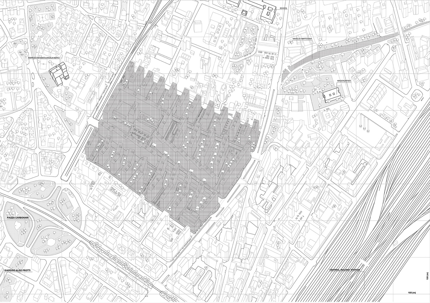
The area of the project represents one of the highest density zones of Milan covered with the typology of condominium housing. It has been chosen as an investigation subject in terms of potential it represents as a model for ''dense city'' living.
The focus of the project is the ground floor as a matrix for physical and social activation of a space.
The research has been carried out at the scales of the city, neighborhood and urban blocks, aiming at mapping different urban relations within the set of context related topics (such as borders, accessibility, flows, land ownership etc.). As a proposal project, different tactics were introduced, creating prototypes that link actors and actions regarding the land transformation
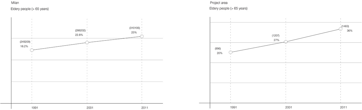
Demographics
Statistics from 1991, 2001, 2011.
Statistics from 1991, 2001, 2011.
Decrease in the total population and growth of the elderly population.

THE GROUNDFLOOR

METHODOLOGY
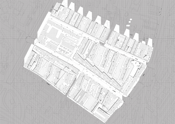
Reading of the urban setting of the blocks, the way they relate to the city and the neighbourhood, create a repetitive pattern of spaces with different qualities, affecting in different ways the urban life, is divided into two parts: mapping of the block’s spatial conditions and a research on the types of the in-between spaces with further classification.
1. SPATIAL LAYERING
The first part represents a mapping of several topics within the area of each block.
The first part represents a mapping of several topics within the area of each block.
2. CLASSIFICATION OF THE SPACES BETWEEN BUILDINGS
Based on the previous study of different topics within the areas of each block, a certain pattern of repetitive conditions becomes visible. In order, to highlight this repetition, the areas of the blocks are fragmented into different pieces of in-between buildings spaces. Each of these spaces represents a certain setting which includes the topics of the previous section which are supplemented with a mapping of the ground floor surfaces.
The important part of this study is given to the architectural section. The levels from the underground to the first one are included in the study, in order to highlight different qualities of the ground floor which are present in all the block and have been articulated in different ways throughout the time.
All the spaces between the buildings are classified into the 10 typologies. The main features which affect the classification of the spaces in-between, are the continuity of the ground floor level, physical accessibility, presence/absence of the commercial services, insolation and size in the cross-section.

The typologies of in-between spaces are re-groupped in relation to 2 factors: their physical parameters and the actors involved in the transformation process:
1. INHABITANTS
Types of the spaces that require less resources for the transformation of their physical condition due to their relatively good parameters are the ones located on the level of the ground floor and facing the main entrances to the condominiums (TYPE1a). These spaces are surrounded only by the residential buildings. Private garden is surrounded with hedges.
The proposed transformation prototype acts on this spaces, dividing them into small portions of land, distributed within the residents, thus reducing the costs for the land maintenance for a piece of extra private space.
2. PRIVATE ACTORS
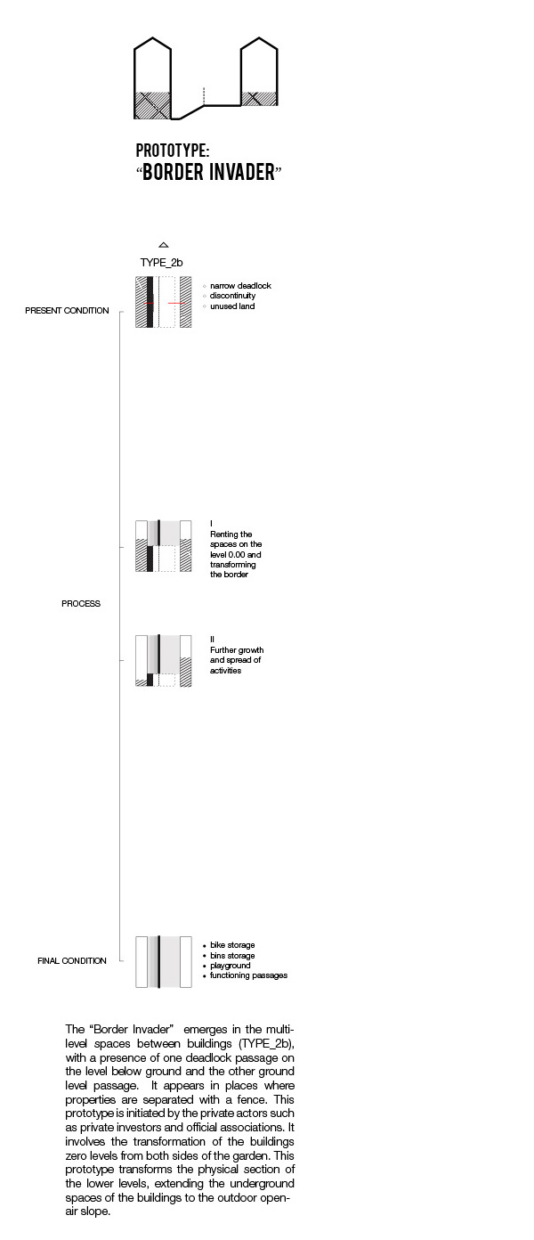
Types of the spaces which are adjacent to existing commercial buildings and have a possibility to connect with them and work as extensions of a certain program (TYPE1b, TYPE2a). The ones requiring less possible physical intervention are given for the usage of the private owners of existing services for the cost of a land maintenance (TYPE1b). Meanwhile the ones which require more modifications, in terms of light structures for bicycle storages and opening of connective paths, improvement of architectural section, are assigned with a social program that intergrates different social groups of the neighborhood, and is driven by the private investors.
3. PRIVATE investors +PUBLIC
The types of the spaces which require certain amout of resources for the improvement of existing condition. These transformations are driven by both private and public actors. These improvements deal more with the transformation of the existing architectural setting of the ground, change of the landscape section through creation of slopes and their usage with connection to the program.
4. PRIVATE inhabitants +PUBLIC
The spaces which have weak physical parameters are groupped together (TYPE 4, TYPE 5, TYPE6b). They are located in the areas of the potential passages through the neighborhood. Importance of their public openess is connected with the emerged social activities inside of the neighborhood. On the other hand they create an outter conection with the activities spread in the city, around the project area. By opening these spaces to the public in certain hours during the day, these passages are maintaned by the municipality and the inhabitants do not pay the maintenace costs.
1. INHABITANTS
Types of the spaces that require less resources for the transformation of their physical condition due to their relatively good parameters are the ones located on the level of the ground floor and facing the main entrances to the condominiums (TYPE1a). These spaces are surrounded only by the residential buildings. Private garden is surrounded with hedges.
The proposed transformation prototype acts on this spaces, dividing them into small portions of land, distributed within the residents, thus reducing the costs for the land maintenance for a piece of extra private space.
2. PRIVATE ACTORS
Types of the spaces which are adjacent to existing commercial buildings and have a possibility to connect with them and work as extensions of a certain program (TYPE1b, TYPE2a). The ones requiring less possible physical intervention are given for the usage of the private owners of existing services for the cost of a land maintenance (TYPE1b). Meanwhile the ones which require more modifications, in terms of light structures for bicycle storages and opening of connective paths, improvement of architectural section, are assigned with a social program that intergrates different social groups of the neighborhood, and is driven by the private investors.
3. PRIVATE investors +PUBLIC
The types of the spaces which require certain amout of resources for the improvement of existing condition. These transformations are driven by both private and public actors. These improvements deal more with the transformation of the existing architectural setting of the ground, change of the landscape section through creation of slopes and their usage with connection to the program.
4. PRIVATE inhabitants +PUBLIC
The spaces which have weak physical parameters are groupped together (TYPE 4, TYPE 5, TYPE6b). They are located in the areas of the potential passages through the neighborhood. Importance of their public openess is connected with the emerged social activities inside of the neighborhood. On the other hand they create an outter conection with the activities spread in the city, around the project area. By opening these spaces to the public in certain hours during the day, these passages are maintaned by the municipality and the inhabitants do not pay the maintenace costs.

The “Activating the ground floor” project is addressing the importance of the ground as the level of the city, which can change the existing spatial and social relations. It deals with the topic of obsolescence, re-thinking the physical setting of the spaces, the ways the buildings touch the ground and relate both to the city and the neighborhood. The project is a social activation, involvment of different social groups, relevant in this area in order to activate the 'frozen' condition of the land.
One of the critical points of the project is the assessment of the area in relation to different actors, which could trigger the transformation process.
One of the critical points of the project is the assessment of the area in relation to different actors, which could trigger the transformation process.
The boundaries of the area test different scenarios of the transformation starting from the residents of the neighborhood as the main private actors of the area and ending with a mix of partially public actions.