
France
3D Cartography
This time we explore the vast and heterogeneous territory of mainland France.
After an overview given by the 1980 geological map, several areas were visualised using the GSGS series of topographic maps produced in 1943 by the British Army.
After an overview given by the 1980 geological map, several areas were visualised using the GSGS series of topographic maps produced in 1943 by the British Army.
This images are a combination of vintage maps and 3D models digitally rendered to show the relief of the territory, through the elaboration of Digital Elevation Model.
If you like our work, want to see our daily work or want to say hello to our studio, consider to follow our Instagram account.
Otherwise if are interested in our prints or have a custom request check our shop Vizcart.io
Otherwise if are interested in our prints or have a custom request check our shop Vizcart.io
For inqueries or commission, feel free to contact us at hello @ vizart . io

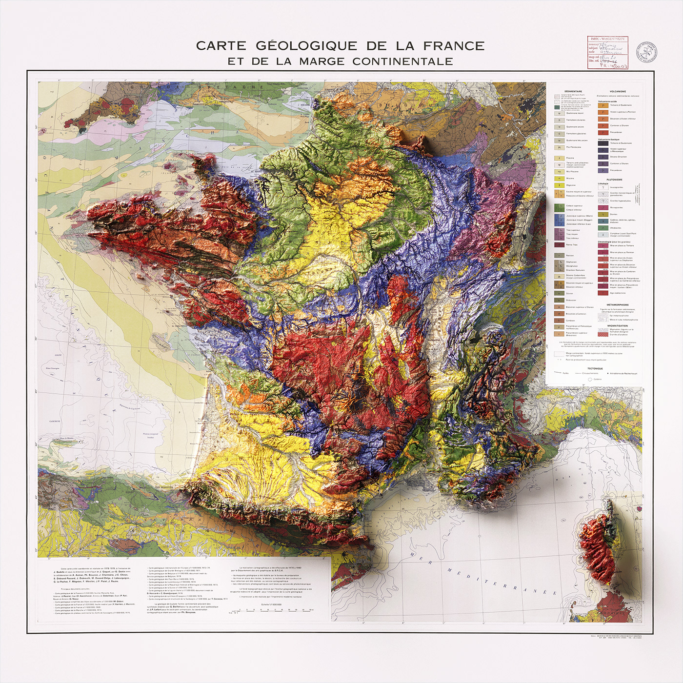
Carte geologique et marge continentale, 1980.
Département des Arts graphiques du B.R.G.M.
Source: ESDAC.
Source: ESDAC.


Avignon. GSGS (Series); 2738. 2nd ed., Great Britain War Office.
General Staff. Geographical Section. 1943.
Source: Mapster
Source: Mapster


Bordeaux. GSGS (Series); 2738. 2nd ed., Great Britain War Office.
General Staff. Geographical Section. 1943.
Source: Mapster
Source: Mapster


Grenoble. GSGS (Series); 2738. 2nd ed., Great Britain War Office.
General Staff. Geographical Section. 1943.
Source: Mapster
Source: Mapster


Lyon. GSGS (Series); 2738. 2nd ed., Great Britain War Office.
General Staff. Geographical Section. 1943.
Source: Mapster
Source: Mapster


Marseilles. GSGS (Series); 2738. 2nd ed., Great Britain War Office.
General Staff. Geographical Section. 1943.
Source: Mapster
Source: Mapster


Toulouse. GSGS (Series); 2738. 2nd ed., Great Britain War Office.
General Staff. Geographical Section. 1943.
Source: Mapster
Source: Mapster


