Par|Durch|Attraverso SOLFERINO
Solferino, first year master Structure, Infrastructure and Landscape Laboratory
Professor: Matteo Bruggi, Sara Protasoni
2015|2016
Professor: Matteo Bruggi, Sara Protasoni
2015|2016
HISTORICAL AND GEOGRAPHICAL OVERVIEW
The geological setting is characterized in the northern part of the moraine hills of Lake Garda, built by large alpine glaciers during the last Ice Age;
in them are well recognizable valleys incisions of the main waterways - Oglio and Mincio and in the southern part of the province, the River Po deemed to be of Holocene age. Among the deposited moraines and the ice front is formed the lake.
From the historical point of view, this territory has been affected by several conflicts over the centuries. We focused on the battles that took place during the last three centuries, since they are the ones who have most influenced the Italian unification.

CONCEPT
Solferino is a village, near Garda Lake, famous for its historic heritage in the II Indipendece War, but visiting this place we find out how weak it’s the strategy to use this cultural potentiality. The only itinerary, called “Four steps into history”, it’s very fragmented and doesn’t allow a dialogue between each monuments and historical places, and it’s limited to a brief description of the events. How is it possible to improve this itinerary?
From an analysis of the Battle of Solferino historic maps, it’s possible to highlight three phases of the battle, and two of them were focused in Pozzo Catena suburb, famous as last Austrian stronghold before the victory of the French-Piedmontese army.

The new panoramic itinerary absorbs this suburb, through prior path, creating a monumental ring, and continues towards Costa Mezzana and Monte Fenile places, full of naturalistic elements.
“Four steps into history” becomes an uniform itinerary, that through punctual installations, allows to discover Solferino in all its aspects.
There are three main themes:
_Battle of Solferino, shows scenes of the battle using visual machines; in Monte Fenile, a tower allows to see the whole area of the battle from the point of view of Napoleone III.
_Historic Context, explains the life of important characters in Solferino’s history, such as Orazio Gonzaga and Henry Dunant, and explains monuments as the Red Cross memorial and the Ossuary.
_Environmental System, tells about typical morphology, vegetation and farming of the area.

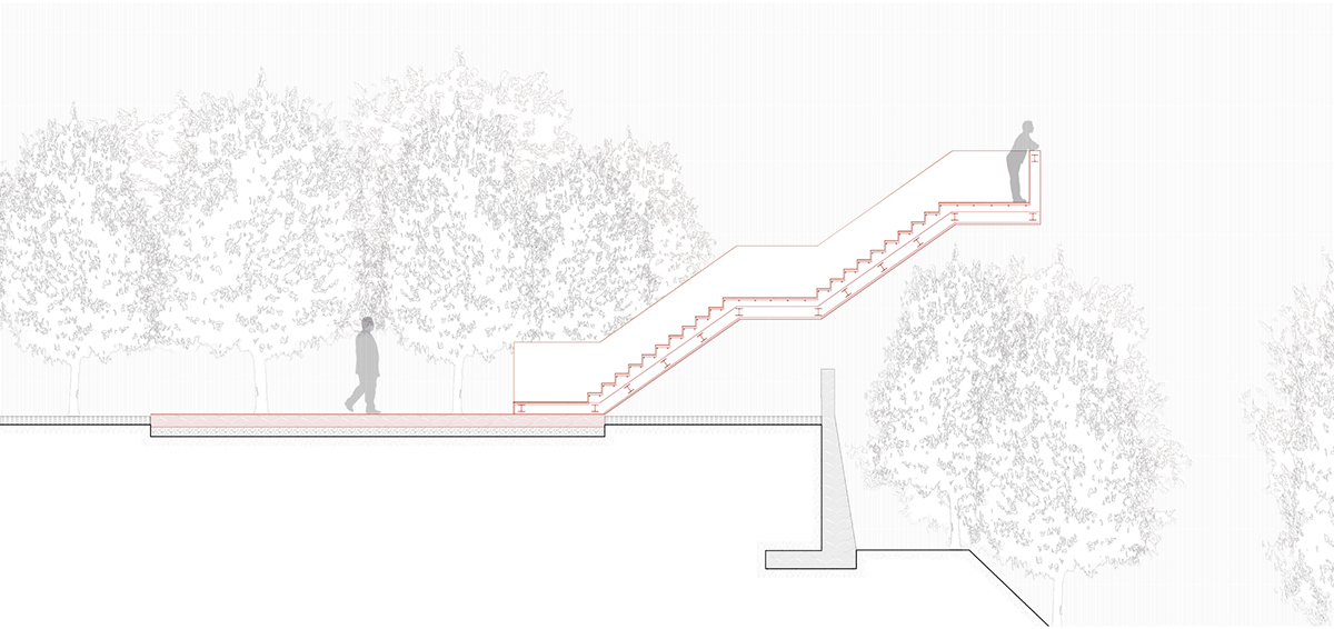
On Monte Fenile Napoleon III arrives the morning of the battle. From here he directs the operations thanks to a broad overview of the battlefield. Through the development of a watchtower we try to recreate the visual condition of the Emperor, also the tower identifies the beginning of the trail and allows a visual and formal dialogue with the fortress, located at the far end opposite the city.


Costa Mezzana, from the historical point of view, assumes great importance due to its location; in fact, it becomes one of the places where the battle rages more and where there were the largest number of victims. Here the path rises through an installation which intercepts the path and allowing a view from the amphitheater moraine, the topography of the area is described.

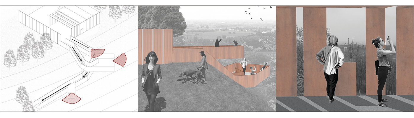

Piazza Castello is located on the highest elevation level of the twentieth-century city. The only monument that is "touched" by "Four Steps in History is the Ossuary.Through a vacuum staircase located at the end of the square there is a visual dialogue with the charnel house; you can also admire the panorama northeast of the hills without any visual impediment.