NEW RESIDENTIAL HOUSING SECTOR IN JURONG, SINGAPORE
We start analyzing Singapore’s urban structure, specifically the western part of the city: Jurong. First of all, it is drawn on a territorial scale Jurong’s density (industry and port area), and it is compared to the island’s nerve and technological center (which is a touristic and working area). From this start, it can be clearly determined the use of each zone. On one hand, the industrial area is a zone which from a territorial point of view occupies more space, whereas the center occupies a much greater surface, although has a greater density.
Secondly, also drawn on a territorial scale, it explains the connection between the center of the island and Jurong. It consists of two main transportation roads, which work as transportation arteries (one that connects the island with Malaysia and the other connects the center with Jurong). These two transportation roads are accompanied by a subway line and two bus lines, which join together in a quick and indirect way these two zones; meaning that these are well connected.
DENSITY

CONNECTIVITY

ZONING AND FACILITIES
Subsequently, it has been explained on a greater territorial scale the three main aspects of the area. In this case, we are talking about the ground’s qualification (difference between industrial, residential and commercial areas) and the zones’ main facilities. Therefore, we can notice a clear predominating industrial use.

TRANSPORTATION ROADS
Secondly, a much more exhaustive analysis of the different transportation roads has been done according to a transportation hierarchy. Starting from the arterial zone roads (which are main distributing roads of the different connections between Malaysia and the center of Singapore) until local roads (which collect all the different areas of the zone).
Secondly, a much more exhaustive analysis of the different transportation roads has been done according to a transportation hierarchy. Starting from the arterial zone roads (which are main distributing roads of the different connections between Malaysia and the center of Singapore) until local roads (which collect all the different areas of the zone).
FREE SPACES
Finally the free spaces of the area have been drawn, which are basically the environment’s blue and green spaces. The most significant point is a big park which is placed on the east side, and which contains a large lake on its interior.
Finally the free spaces of the area have been drawn, which are basically the environment’s blue and green spaces. The most significant point is a big park which is placed on the east side, and which contains a large lake on its interior.

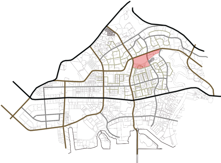
ANALYSIS OF THE ACTING AREA
A plant of the area which it is aim to act on and on which a further planning will be done, has been drawn on an urban scale. This plant explains the essential and main aspects which can influence on a further project. In the first place, the importance of the park’s situation (and lake’s situation on its interior) and the presence of important water channels of the zone. One of these, divides in two the area which we are acting on. The road axis also acquired relevance due to the fact that separates the residential area from the industrial one.
I must highlight that it is an area which incorporates a series of important facilities with a big number of educational institutions. An aspect which we must have into consideration is that one of the main cities’ arterial roads is placed tangentially to the area in action. This generates a good connectivity between the center, using either a car or public transportation.
I must highlight that it is an area which incorporates a series of important facilities with a big number of educational institutions. An aspect which we must have into consideration is that one of the main cities’ arterial roads is placed tangentially to the area in action. This generates a good connectivity between the center, using either a car or public transportation.

DIAGRAMMATIC EXPLANATION OF THE PLANNING PROJECT
I. AXES AND STREETS
The first premise is to create two linear and connective axis. They link all the front of the main transportation road with the subway line, where this linking axis connects itself with the other subway proposed line. The connecting axis is proposed as a linear and green pedestrian road, where the main facilities (such as college, commercial or schools) of the proposed project link to the residential area through this axis. Another premise is the linear extension of the existing streets throughout the area of action, in order to connect it with the main road.
II. TYPOLOGY OF ROADS
We can differentiate 4 road typologies. The first type are the existing roads. These are high traffic roads that communicate or link strategically points of the country or from outside. Another type of roads are urban roads. From these we can differentiate two types: the main urban roads (which are extension of existing roads) and secondary urban roads (which serve to communicate the different residential zones). The most important road is the fourth type: the pedestrian green road. This connects all the facilities with the residential zone in a very lineal form, giving it a unitary and uniform character.
III. FREE SPACES
We can distinguish three types of free spaces. The first type are free public spaces. These type are those that have a “green” axis parallel to the blue axis and which changes its shape according to its environment and to the necessities of the area. Secondly, there are free spaces which are considered to be semi-private free spaces. This type of spaces exclusively treat with multi-family buildings, especially those spaces which are interstitial spaces among them. And at last, free private spaces. These type only appear in single-family buildings and its use is exclusively for them.
IV. BUILT-UP SPACES
We can differentiate two types. When we talk about facilities, each facility will have a necessary height for its own use. We will have different parts, such as, commercial, educational, sporting, hospitable, and the most important, transportation parts (it is the most important because gives a quick access and connection). On the other hand, in residential areas we can distinguish two types of buildings: the single-family buildings (with its own garden and with heights of ground floors +1) and multi-family buildings (with different floor heights and with building modular blocks with dimensions of 12 x 40 m).

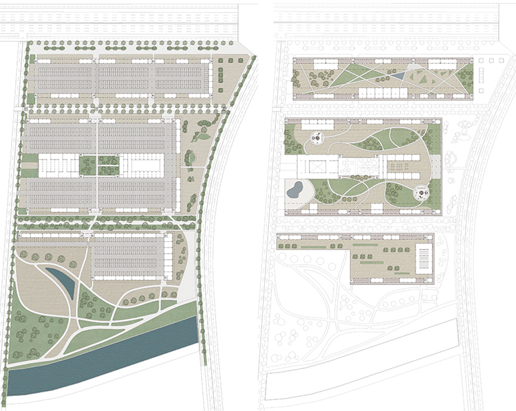
URBAN PLANNING PROJECT
The urban planning proposed project is on a 1:5000 scale. The streets are detailed and we look for a constructing typology (using as a starting point the surrounding existing buildings). Basically, we propose two types of buildings, blocks of single-family and multi-family houses. Green spaces are also detailed, from a lineal axis which is parallel to the blue axis, and which changes shape according to its surrounding necessities. It works like an “acoustic cushion” when it comes to insulate the streets against the environmental sounds of the closest blocks. The facilities are placed strategically in order to give new facilities to the area in question; facilities which do not exist around the close environments.

PUBLIC SPACE: GROUND AND FIRST FLOOR
LIFTING THE GROUND FLOOR LEVEL
As the title well indicates the main building project’s intention is to lift the ground floor level in order to generate private public spaces, focused toward the people which live in the adjacent buildings; but always having into consideration that any neighbor or citizen can come to distract themselves, eat food, go shopping…etc. It is referred to the intention of “privatizing” the public spaces to the point that a person would want to come to live here, due to the fact that the space will be provided with certain requirement which he/she will lack or will be hard to find in their environment. Nevertheless, we will never have to forget that this residential area is placed in the Jurong’s (Singapore) industrial area. We must create an attractive area for people to want to come to live in this area, which as a matter of fact, is a very “strong” area. As it is unusual, projecting public spaces as plazas, parks, … in ground level, in relationship to its neighboring buildings, but the main idea of this project is to lift this space on to the first level (approximately 5 m from the ground) in order for the neighbors of the buildings. The building blocks which are focused toward the interior of each isle, equipped with exterior pathways, in order to centralize and focalize the activity on to the interior. Due to the fact that Singapore is placed at the Ecuador, the sun influences the same way that in North and South areas; therefore the living rooms of these buildings can be placed facing North and South with some horizontal and vertical communications.
As the title well indicates the main building project’s intention is to lift the ground floor level in order to generate private public spaces, focused toward the people which live in the adjacent buildings; but always having into consideration that any neighbor or citizen can come to distract themselves, eat food, go shopping…etc. It is referred to the intention of “privatizing” the public spaces to the point that a person would want to come to live here, due to the fact that the space will be provided with certain requirement which he/she will lack or will be hard to find in their environment. Nevertheless, we will never have to forget that this residential area is placed in the Jurong’s (Singapore) industrial area. We must create an attractive area for people to want to come to live in this area, which as a matter of fact, is a very “strong” area. As it is unusual, projecting public spaces as plazas, parks, … in ground level, in relationship to its neighboring buildings, but the main idea of this project is to lift this space on to the first level (approximately 5 m from the ground) in order for the neighbors of the buildings. The building blocks which are focused toward the interior of each isle, equipped with exterior pathways, in order to centralize and focalize the activity on to the interior. Due to the fact that Singapore is placed at the Ecuador, the sun influences the same way that in North and South areas; therefore the living rooms of these buildings can be placed facing North and South with some horizontal and vertical communications.
“PRIVATE” PUBLIC SPACE
What it is thought to do, when lifting the “ground floor” in order to create these private free spaces, is to take benefit of the ground floor for the use of parking lots, which are completely outdoors and ventilated, and having an access to them on one of the isle’s sides (east side). In Singapore, all parking lots are placed outdoors, and most of the times form part of the first levels of the buildings. The accesses to the different vertical communications of the building are placed on opposite sides (on North and South). We also take benefit of the ground floor level in order to place some of the program needed and diverse facilities, such as a car repair shops and a car dealership; with a gymnasium and a swimming pool. A part from this, we have also thought about all the placement of the perimeter, acting as parking lot “walls”, for the placement of different establishments such as offices, commercial areas, or simply as storerooms for the own neighbors of the buildings. The first floor is projected in order to create a series of roads/pathways which connect various buildings to relevant points of the project; a part from placing the program for the isle’s autonomous functioning. Program such as civic centers, educational establishments, shops, entertainment establishments (such as bars, restaurants, game rooms …). It is a space thought to give “life” to the isle and therefore, be a much attractive area when going to buy a building in an industrial area.
What it is thought to do, when lifting the “ground floor” in order to create these private free spaces, is to take benefit of the ground floor for the use of parking lots, which are completely outdoors and ventilated, and having an access to them on one of the isle’s sides (east side). In Singapore, all parking lots are placed outdoors, and most of the times form part of the first levels of the buildings. The accesses to the different vertical communications of the building are placed on opposite sides (on North and South). We also take benefit of the ground floor level in order to place some of the program needed and diverse facilities, such as a car repair shops and a car dealership; with a gymnasium and a swimming pool. A part from this, we have also thought about all the placement of the perimeter, acting as parking lot “walls”, for the placement of different establishments such as offices, commercial areas, or simply as storerooms for the own neighbors of the buildings. The first floor is projected in order to create a series of roads/pathways which connect various buildings to relevant points of the project; a part from placing the program for the isle’s autonomous functioning. Program such as civic centers, educational establishments, shops, entertainment establishments (such as bars, restaurants, game rooms …). It is a space thought to give “life” to the isle and therefore, be a much attractive area when going to buy a building in an industrial area.
THE BUILDING: HOUSING FLOOR AND SECTIONS
THE LINEAL BLOCK
EXTERIOR PATHWAYS
The main intention for the typology of these lineal blocks is to follow their same model. Due to the fact that Singapore is a place which permit these type of blocks, a place where the temperature during the whole year is mainly pleasant, we propose the idea of exterior ventilated pathways and roofs only for the top structural floor. The intention of creating this is to communicate each staircases, which are placed differently on each block; at the main entrance of each house. This continuous pathway permits the relation and connection between the different residents of the building; permitting the creation of outdoor “streets” on the own building.
The studied plot consists of different typologies of lineal blocks which are placed in different ways. As a start, there are three exterior lineal blocks joined by its corners forming a “U”-shape. You can differentiate them due to the position of its vertical communications (stairs) and its pathways (both on opposite sides). These blocks have a length of 80m, a width of 15m and a height of 30m. There are two linear blocks joined on each of their sides forming a continuous building, and two more buildings joined on the other sides; meaning that all the buildings are joined among them on their sides; and at the same time, are joined by exterior continuous pathways. The four central blocks, which are also lineal blocks but with different dimensions, are separated between them. These blocks have a length of 55m, a width of 10m and a height of 24m. Regarding the housing typology of each block; the plot’s exterior blocks (the ones that form the “U”-shape) have housing typologies 1 and 3 (which are meant to be for large families that have between 3 to 4 people); whereas for the interior lineal blocks, we only find typology 2 (for families of two members). The fourth typology is thought to be for the bottom isle, where the building creates individual houses for the residence of students.
EXTERIOR PATHWAYS
The main intention for the typology of these lineal blocks is to follow their same model. Due to the fact that Singapore is a place which permit these type of blocks, a place where the temperature during the whole year is mainly pleasant, we propose the idea of exterior ventilated pathways and roofs only for the top structural floor. The intention of creating this is to communicate each staircases, which are placed differently on each block; at the main entrance of each house. This continuous pathway permits the relation and connection between the different residents of the building; permitting the creation of outdoor “streets” on the own building.

FINAL PRESENTATION


