


________________________________________________________
Context, Form + Dynamics (summary)
A regional analysis of Dublin's growth and form indicates a suburban shift in living across the Greater Dublin Area. The city centre shows slower rates of development, densification and investment.

Regional context analysis: Transport, Topography, County Areas, Sprawl;

Height analysis of structures across the island of Ireland;
Poolbeg Chimney stacks (far right): 207.8m.
Poolbeg Chimney stacks (far right): 207.8m.
Historic mapping indicates the extreme extent of land engineering that was necessary to develop the land that much of Dublin Port and the region's coastal industries now occupy. Transport connections into and around Dublin City centre are a cobweb of arterial routes that radiate out from a Georgian core. The River Liffey does not dominate as a route through the city: it is a neglected and ignored resource that Dublin has turned its back on.

Historic form of Dublin Bay and River Liffey;

Dublin City: Existing public transport corridors (left), and existing hierarchy of road networks (right);
________________________________________________________
Concept Development (summary)

A greater strategy is developed for Dublin City centre, establishing a cohesive urban framework of public realm and public spaces that is focused along the River Liffey. This urban axis runs east-west through the city, leading from the Phoenix Park right out into Dublin Bay. Along it are heritage, shopping, service and areas; it becomes a new and vibrant urban corridor through Dublin: a transition of urban thresholds from vast parklands to the city centre, and out into the Irish Sea along the Great South Wall.


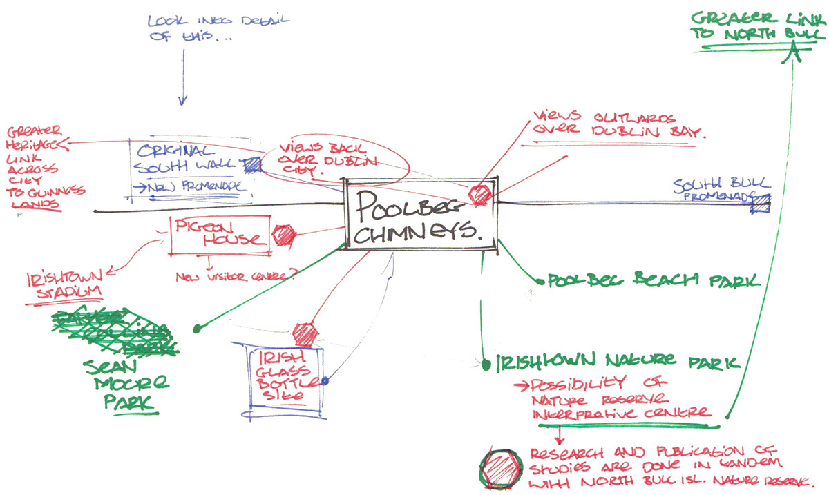
At the east end of Dublin City is Poolbeg - a peninsula of land that remains generally industrialised and relatively undeveloped for the public. Across this area, however, is a diverse range of land uses and landscapes: areas of architectural, environmental, social and historic significance. At its core are the iconic Poolbeg chimney stacks, which are re-examined (below) as a a major public utility area and vibrant urban core of the Poolbeg Peninsula.
An improved public realm framework, prioritising pedestrian and cycle routes into and across Poolbeg, begins to link in with the regional Liffey axis concept through the city centre. As it progresses across the peninsula, it reaches the open and isolated South Wall Lighthouse, marking the termination point of the greater South Wall axis that runs through the city centre.

________________________________________________________
Strategy and Master Site Plan (summary)
A proposal of interventions across Poolbeg are spatially described in the Master Site Plan. This aims to inform further design and development across the site, offering a long-term vision for improved transport connections, a more accessible urban quarter and an integrated coastal management plan that aims to operate in tandem with the greater coastal environmental initiatives.

Central to the greater urban design of Poolbeg is how it operates as part of the greater urban axis through Dublin City. A system of bicycle and pedestrian routes is developed, themed on the peninsula's three contrasting merits: a Heritage Trail, an Environmental Cycle Network, and a seascape walkway: The Dublin Bay Way. These are proposed to link together with the successes of the existing DublinBikes scheme across the city centre.

Poolbeg Peninsula begins to operate as a compact urban quarter of diverse land uses, ranging from the utility zones of the industrial ports, to the mixed-use core of Poolbeg Quarter, to the diverse coastal landscape systems that offer an environmentally dynamic and educational resource to the wider region. The peninsula is reconsidered as a unique transition of urban thresholds.

Spatial configuration of surrounding road networks allows the continued industrial connections to the peninsula, while also improving the pedestrian and cycle networks into and around the site (below). This long-term phased site plan also integrates the existing urban tram network into the site (below) along the Red Luas Line - conceptually proposed in the Greater Dublin Area Transport Strategy 2011- 2030.

________________________________________________________
Detailing (summary)
A series of smaller, more detailed studies were undertaken to examine the spatial configuration of proposals from the Master Site Plan. These focused initially around the Pigeon House Complex of buildings, where an abandoned power station, an beautiful granite house and the Council's Waste-Water facilities are re-imagined as a dynamic science centre and city-wide attraction. The highlight of this development is centered around a new viewing platform at the highest point in the city - the west chimney stack - offering a 200-metre high vista over a dynamic and historic city centre.

The diversity of coastal landscapes across Dublin Bay are approached through a proposed Coastal Landscape Management Plan that integrates also with North Bull Island's interpretive centre and Booterstown Bird Sanctuary, providing Dublin with a cohesive coastal biodiversity initiative.

Dublin's waste management targets are met through the proposed Waste-To-Energy Incineration project, though they are conceptualised here as an integrated element in the Poolbeg Landscape: combining the utility of the project requirements with the environmental requirements of the immediate surrounds of the peninsula. Rather than attempting to screen the facility, it is embraced and exploited as an environmental asset.

________________________________________________________
Conclusion
Poolbeg offers to Dublin City an opportunity to re-establish a connection with the Bay upon which it was once established. The significance of the River Liffey plays a large part in connecting many of the city centre's successes with those coastal proposals that are suggested at Poolbeg. Combining new and dynamic public facilities with the beauty of the capital city's environmental assets along the coast, whilst retaining the industrial and utility zones of the area, brings together an urban design proposal that aims to connect a currently fragmented public realm and a relatively successful transport scheme to the coast. The South Wall is an ambitious and progressive proposal for Dublin. Please see the full documented proposal (top of page).


________________________________________________________


