

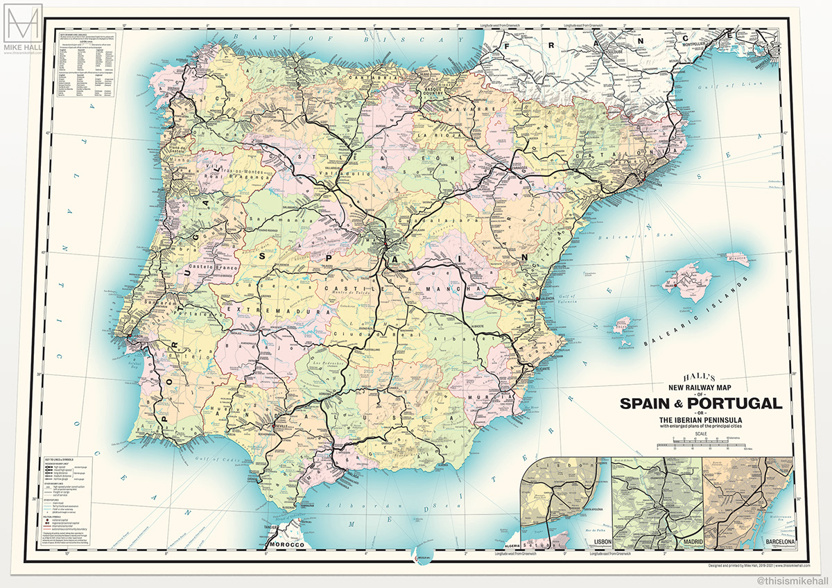
This design for a map of the modern-day railway network in Spain and Portugal is an adaptation of an earlier map design and takes its inspiration from vintage railway network maps of the early 20th centuries.
It's available to purchase as a fine art print in two sizes from my online store.
March 2021 note: The design has now been updated to include:
- The newly opened AVE (high speed) lines between Alicante-Orihuela and Puebla de Sanabria-Zamora
- Various new high speed lines currently under construction including: Badajoz-Évora, Bilbao-Irún-Vitoria, Murcia-Almería, Pamplona-Zaragoza, Plasencia-Badajoz and Valencia-Xativa
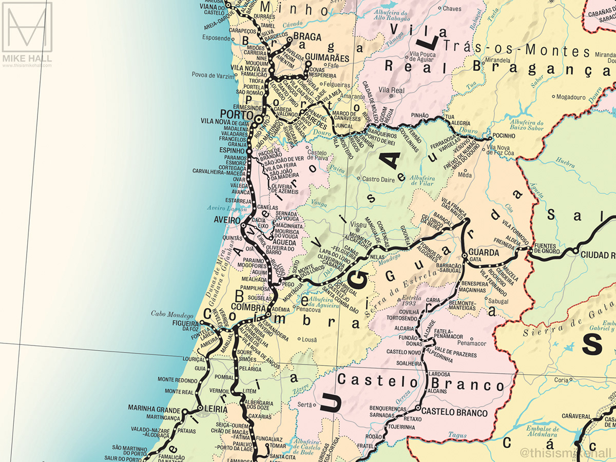
- The newly reopened section of the Linha Beira Baixa between Covilhã-Guarda
Click here to view the whole map in closer detail.

Detail of the title card and scale bar. The arch-shaped HALL'S logo is an homage to that used by G.W. Bacon & Co on its maps in the early 20th century.
My map displays all state-owned railways lines within Spain and Portugal that are (as of March 2021) either open to passenger and freight traffic, including the entire Renfe and Comboios networks and smaller regional networks, and new lines under construction.

Detail of the Lisbon metropolitan area.
Note on language: This is an English-language map, therefore all names are spelt in the forms by which they are commonly or officially known in English. In the case of cities, their co-official or alternative names in Spanish, Portuguese or other regional languages are written in smaller type alongside e.g. Lisbon/Lisboa, Seville/Sevilla etc.
All railways are represented by solid black lines, with stations marked with dots or circles; larger circles generally represent larger cities or important interchanges.

The various types of railway line are represented by a variety of stroke widths and styles, graduating from the thickest (high speed lines) to the thinnest (branch lines and single-track, narrow-gauge railways).

This detail shows the extensive narrow-gauge Renfe Feve network which connects most of the northern coast of Spain with León and Santander.

Sections of the networks in southern France and northern Morocco that fall within the map’s area are also shown, along with sea ferry routes and main automobile roads.

Freight lines are represented by thin lines with perpendicular dashes, while lines that are no longer in use but still intact (such as the line between Colmenar Viejo and Aranda de Duero, north of Madrid) are represented by thinner dashed lines. Abandoned or closed lines that are no longer intact are not shown. Some stations are omitted where there is a lack of space.

Detail of the Madrid metropolitan area.
Metro or other rapid transit networks of individual cities (such as the Barcelona or Madrid metro networks) are not shown as these would be too small to show clearly at this scale. Enlarged city-centre maps of Madrid, Barcelona and Lisbon appear at the bottom right corner of the design (see below).

The map doesn't attempt to display the routes of specific train services or other service patterns provided by the respective operators that a modern transit map might; its principal purpose is to present the railway networks of the two countries in a simple but aesthetically interesting way.

The planned courses of high-speed AVE (Alta Velocidad Española) lines which are under construction as of March 2021, such as those in this detail between Plasencia, Cáceres, Mérida and Badajoz in Extremadura, are represented by double-dashed lines. Their projected opening dates are displayed alongside.

Various weights and styles of the sans-serif Bureau Grotesque typeface family are used for all rail, urban, regional and political labels. Though a modern design created in 1989, this typeface convincingly evokes sans-serif typefaces of the period.

All geographical and natural features, including mountain ranges, peaks, natural parks, rivers, reservoirs, lakes and seas are set in Old Standard Italic.

The design was created entirely using Illustrator with the exception of the shaded mountain relief, which was created in Photoshop.

In this detail can be seen various narrow-gauge railway lines along the Costa Blanca, including the FGV (Ferrocarrils de la Generalitat Valenciana) line between Alicante and Dénia, and the Renfe Feve line between Cartagena and Los Nietos in Murcia.

Provincial boundaries are marked with thin dotted lines and individually coloured using a 4-colour range; autonomous community boundaries and international borders are marked with increasingly thicker dashed black lines with red backgrounds.

Sparsely-populated regions with few adequate railway connections are clearly in evidence on the map, in particular regions such as the eastern part of Teruel province (Teruel being the only provincial capital in Spain still without a direct railway connection to Madrid).

By contrast, the Catalonia region is one of the most densely populated regions on the map, with many lines and stations contained within a relatively small area. This proved to be the most challenging part of the map to draw; the distribution of the labels took several attempts to complete.

Detail of the Barcelona metropolitan area.
As with other metro and light rail systems the Barcelona metro system is not shown, however two commuter lines operated by FGC (Ferrocarrils de la Generalitat de Catalunya) between the city centre and the towns of Igualada and Manresa are shown.

Detail of the Balearic Islands of Mallorca, Minorca and Ibiza. The narrow-gauge railway lines that cross Mallorca operated by SFM (Serveis Ferroviaris de Mallorca) and Ferrocarril de Sóller are both shown.
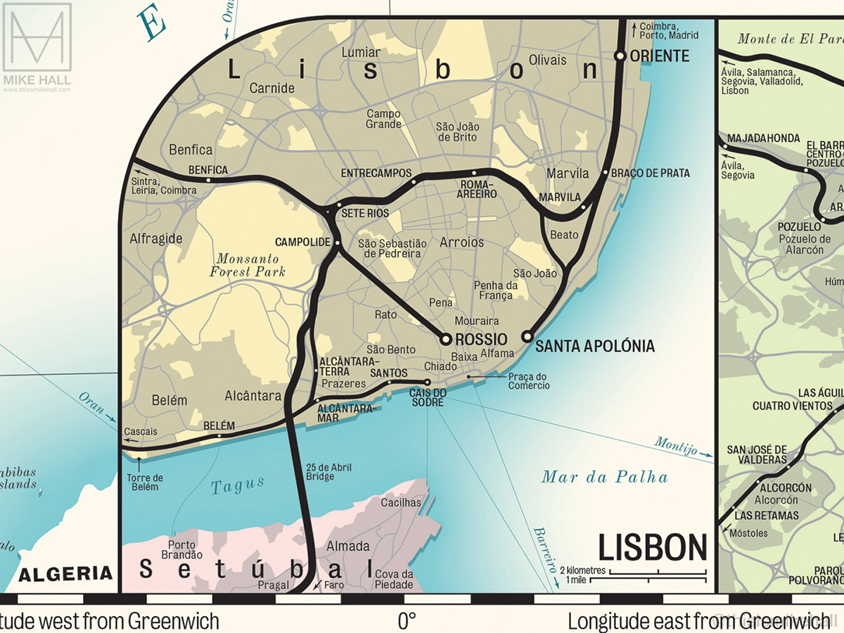
At the bottom right corner are inset maps of the three largest cities (Lisbon, Madrid and Barcelona) that show the detail near their centres with more clarity at a larger scale.


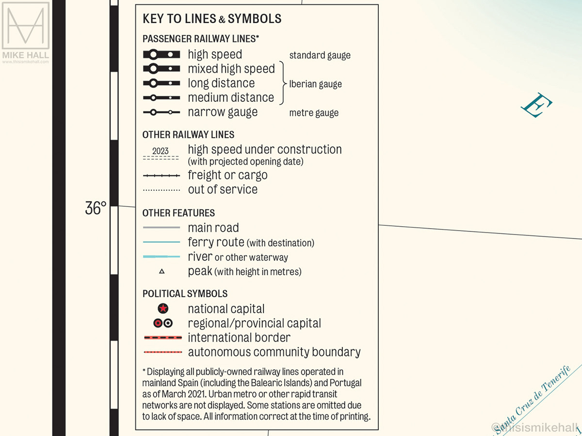
Detail of the key to lines and symbols which appears at the bottom left corner.
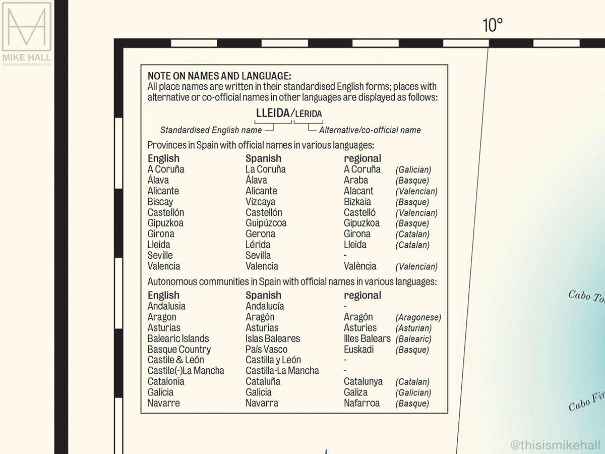
The note on language and guide to names in other languages which appears at the top left corner.

A mock-up of the map printed and displayed in a 70 x 50 centimetre frame.
Resources: ADIF, Comboios, Enterat.com, Euskotren, Google Maps, Pablo Marinas (PaMap), OpenStreetMap, Renfe, SNCF, Wikipedia.
Resources: ADIF, Comboios, Enterat.com, Euskotren, Google Maps, Pablo Marinas (PaMap), OpenStreetMap, Renfe, SNCF, Wikipedia.


