


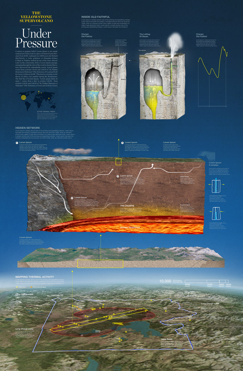
In October, 2015, we (Shelley and I) traveled to Yellowstone Park to gather information about the geothermal activity and its source. Based on this information, I designed two infographics, this is the second one where I focused on the plumbing system beneath the park. Water from rain and snowmelt, much of it centuries old,percolates down through cracks in the Earth’s crust. The water is heated by magma reservoirs to well over the surface boiling point, but remains in a liquid state because of the pressure of overlying rock and colder water. The superheated water filters upward, eventually finding release in the thousands of geysers, hot springs, and other hydrothermal wonders.


EDITOR: MANUEL CANALES. ART: HERNÁN CAÑELLAS, CHARLES PREPPERNAU, MANUEL CANALES. MAP: CHARLES PREPPERNAU, ANDREW UMENTUM. GIS: THEODORE A. SICKLEY. CONSULTANTS: DUNCAN FOLEY, PACIFIC LUTHERAN. UNIVERSITY; ROBERT FOURNIER, USGS; HENRY HEASLER, CHERYL JAWOROWSKI, NATIONAL PARK SERVICE; JACOB LOWENSTERN, USGS; ROBERT B. SMITH, JAMIE FARRELL, UNIVERSITY OF UTAH.RESEARCH: SHELLEY SPERRY. TEXT: EVE CONANT. DESIGN: BILL MARR, SANDI OWATVEROT-NUZZO.PRODUCTION: DANIELA SANTAMARINA. MAP EDIT: GUS PLATIS. SOURCES: K. A. BARRICK, ENVIRONMENTAL REVIEWS, 2010 (VANISHING GEYSERS); S. HURWITZ, ET AL., JOURNAL OF GEOPHYSICAL RESEARCH, 2014 (SHAKEN FAITH); NPS (HYDROTHERMAL FEATURES); USGS; USDA NATIONAL AGRICULTURE IMAGERY. PROGRAM (MAP IMAGERY). COPYRIGHT © 2016 NATIONAL GEOGRAPHIC PARTNERS, LLC, WASHINGTON, D.C. PRINTED FEBRUARY 2016

https://on.natgeo.com/2WVrriV


