
Iceland
A collection of images from the remarkable landscape of Iceland
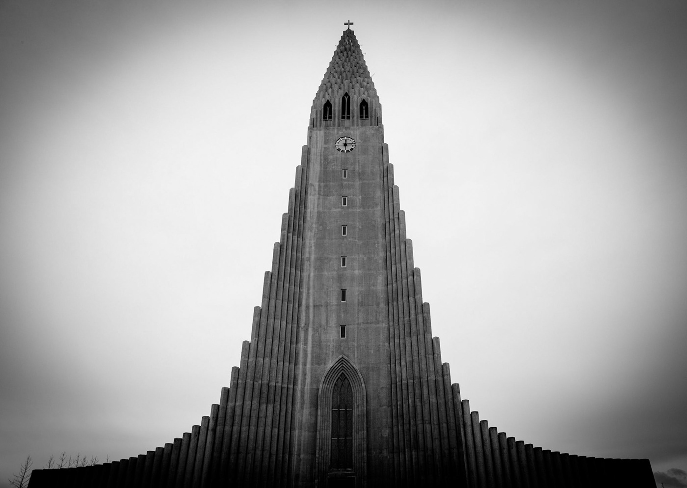
Hallgrímskirkja
Hallgrímskirkja is a Lutheran (Church of Iceland) parish church in Reykjavík, Iceland. At 73 metres (244 ft) tall, it is the largest church in Iceland. The church is named after the Icelandic poet and clergyman Hallgrímur Pétursson (1614 to 1674), author of the Passion Hymns. State Architect Guðjón Samúelsson’s design of the church was commissioned in 1937 and it is said he designed it to resemble the basalt lava flows of Iceland’s landscape.
It took 38 years to build; construction began in 1945 and ended in 1986, with the landmark tower being completed long before the church’s actual completion. The crypt beneath the choir was consecrated in 1948, the steeple and wings were completed in 1974 and the nave was consecrated in 1986. Situated in the centre of Reykjavík, it is one of the city’s best-known landmarks and is visible throughout the city.
The church houses a large pipe organ by the German organ builder Johannes Klais of Bonn which has a mechanical action, four manuals and pedal, 102 ranks, 72 stops and 5,275 pipes. It is 15 metres tall and weighs 25 tons. Visitors to the church can take a lift up to the viewing deck and view Reykjavík and the surrounding mountains.
The statue of explorer Leif Eriksson (c. 970 – c. 1020) by Alexander Stirling Calder in front of the church predates its construction. It was a gift from the United States in honour of the 1930 Alþingi Millennial Festival, commemorating the 1,000th anniversary of Iceland’s parliament at Þingvellir in 930 AD.
Hallgrimskirkja cathedral, Reykjavik

Hallgrimskirkja cathedral, Reykjavik

Hallgrimskirkja cathedral, Reykjavik
The Icelandic crash?
Crashed: Saturday 24 November 1973
Type: Douglas R4D-8 (Super DC-3)
Operator: United States Navy
Fatalities: 0
Location: Sólheimasandur
Type: Douglas R4D-8 (Super DC-3)
Operator: United States Navy
Fatalities: 0
Location: Sólheimasandur
In 1973 a Douglas C-117 [military version of a DC-3] plane is said to have ran out of fuel in bad weather and had to crash-land on the black-sand a little west of Vik. Everyone survived but during the attempted recovery a helicopter crashed, killing some members of the crew. Local rumour has it that a farmer visited the site and discovered the pilots had mistakenly switched to the wrong fuel tank and actually had a second, completely full load. The farmer then had aviation grade fuel to run all his tractors for a year. He also sold off the tail to a couple who ran a hotel out of a DC-3. Most likely a tall tale but the truth is already lost to history.

Solheimasandur

Solheimasandur

Solheimasandur
Elves - 'the hidden people'
The 'hidden people' or huldufolk are like elves. They look like humans and are believed to live in the lava rocks. According to legend, Eve hadn't finished washing her children when God came to visit, so she had to hide the unwashed children away, and they were destined to remain forever ‘hidden.’
The elves of Iceland are considered benevolent beings but are fiercely protective of their homes. Traditionally, great harm has come to those who disturb an elf’s dwelling.
Respectful of their elfin neighbors, Icelanders go to great lengths to avoid disturbing rocks where elves are said to live. There are several cases where the highway department has consulted local ‘elf experts’ who recommend alternative routes for new roads so they will do the least harm to the Huldufolk.
Elves are invisible to nearly all humans, but are most likely to be spotted on certain days of the year: New Year's Eve, Twelfth Night, Midsummer Night and Christmas.
Trolls are equally elusive members of the Icelandic folklore. They only come out after dark because if they are caught in sunlight they turn into stone. The Icelandic countryside is scattered with oddly shaped lava formations that are said to be the bodies of petrified trolls, trapped in stone for all time, but as you walk through these enormous lava fields, you’ll swear something moved!

Icelandic trolls

Icelandic trolls
Skeidarárjökull
Heading off along a rough track, across the vast black-sand desert-like plains towards the Skeiðarárjökull glacier, the glacier never seemed to get any closer, such was the size of the glacier and surrounding landscape. This whole area is one vast flood-plane casued by glacial melt-water after a small volcanic eruption in 1996. This “small” eruption produced some incredible figures: In 1996, when the volcano under the Grímsvötn lakes belonging to the Vatnajökull glacier erupted, the river Skeiðará flooded the land in front of Skaftafell, now part of Vatnajökull National Park.
The jökulhlaup (glacial flood) reached a flow rate of 55,000 cubic metres per second, and destroyed parts of the Hringvegur (Ring Road or Iceland Road #1). The flood carried ice floes that weighed up to 1,000 tons. The reinforced-concrete bridge over the Gígja River was totally swept away. The 900 meter (3,000 feet) Skeidará River Bridge was severely damaged, even though its foundations were buried to a depth of 15 meters (50 feet) to withstand mega-floods. Iceland’s main high-tension power-lines were severed, and the telephone cables ripped apart.
The tsunami released was up to 4 metres (13 ft) high and 600 metres (660 yd) wide. The flood carried with it 185 million tons of silt. The peak water release from the lake that developed around the Grímsvötn Volcanic Crater in the center of the Vatnajökull ice cap generated flows that exceeded the volume of the Mississippi River. The jökulhlaup flow made it, for several days, the world’s 2nd largest river (in terms of water flow) after the Amazon. After the flooding, some icebergs 10 metres (33 ft) high could be seen on the banks of the river where the glacial melt-waters had left them behind. The outbursts have occurred in 1954, 1960, 1965, 1972, 1976, 1982, 1983, 1986, 1991 and 1996.
In 1996, the eruption melted 3 cubic kilometres (0.73cu miles) of ice, eroded 3-km-wide canyons and dumped 9 meters of sediment over 500 square km. Icelanders now await the “big” eruption.

Skeidararjokull
Jökulsárlón
Jökulsárlón (literally “glacial river lagoon”) is a large glacial lake in southeast Iceland, on the edge of Vatnajökull National Park. Situated at the head of part of the Breiðamerkurjökull glacier, it developed into a lake after the glacier started receding from the edge of the Atlantic Ocean. The lake has grown since, at varying rates, due to the melting of the glaciers. It is now 1.5 kilometres (0.93 miles) away from the ocean’s edge and covers an area of about 18 km2 (6.9 sq mi). It recently became the deepest lake in Iceland, at over 248 metres (814 ft), as glacial retreat extended its boundaries. The size of the lake has increased fourfold since the 1970s.
Icebergs from the lake drift out, under the road bridge, to the sea and are then dramatically tossed back onto shore by the North Atlantic waves. It is considered one of the natural wonders of Iceland.

Jokulsarlon

Jokulsarlon

Jokulsarlon

Breidamerkurjokull
Sólheimajökull glacier
Sólheimajökull glacier feeds off the enormous Mýrdalsjökull icesheet. With the help of a guide, we explored one morning, armed with crampons and ice axes.
The remarkable light and dark shades of the glacier are caused by the wind blowing fine sand across the white glacier which sometimes settles temporarily on the surface or remains trapped to produce veins of darkness through the ice. Unfortunately, these dark patches catch the sun’s rays and accelerate the already rapid melting of the ice. The area we parked our car was once the snout of the glacier just 5 years previously. That snout is now a 300m walk away.
Later that same day we got lost! High on the Mýrdalsjökull icesheet we raced through a complete whiteout and freezing temperatures on a snow-mobile. Thankfully the guide knew how to use his GPS with remarkable accuracy, although it didn’t stop him driving into a mini crevass.

Solheimajokull

Myrdalsjokull
Skogafoss

Skogafoss

Skogafoss
Dyrhólaey and Vik
The small peninsula, Dyrhólaey is located on the south coast of Iceland, not far from the village of Vík. It was formerly an island of volcanic origin. The view north from Dyrhólaey reveals the giant glacier, Mýrdalsjökull. To the east are the black lava stacks of Reynisdrangar rising from the sea, and to the west the whole coastline in the direction of Selfoss is visible. In front of the peninsula, there is a gigantic black arch of lava standing in the sea which gave the peninsula its name (meaning: the hill-island with the door-hole). In the summertime, puffins nest on the cliff faces of Dyrhólaey.

Solheimasandur

Dyrholaåey

Dyrholaåey

Dyrholaåey, sea stacks

Dyrholaåey

Dyrholaåey lighthouse

Whale bones, Solheimasandur
Seljalandfoss

Seljalandfoss
The red years: the 3,000 year old Kerið caldera

Keiro crater
Around Þingvellir
The serenity in the countryside around Þingvellir and Þingvellir itself is palpable. Gone are the rugged mountains, glaciers and black-sand beaches and in their place are wide vistas, lakes and small extinct volcanoes from another era. It is little wonder that the Vikings and their descendants chose this area for their great meetings and first forms of government.
Þingvellir is in Bláskógabyggð in southwestern Iceland, near the peninsula of Reykjanes and the Hengill volcanic area. Þingvellir is a place of historical, cultural, and geological importance and is one of the most popular tourist destinations in Iceland. It is the site of a rift valley that marks the crest of the Mid-Atlantic Ridge, which means on one side you can stand on the Eurasian tectonic plate and on the other the North American, just a few short steps away. It is also home to Þingvallavatn, the largest natural lake in Iceland.
Parliament, or Alþingi, was established at Þingvellir in 930 and remained there until 1798. Þingvellir National Park was founded in 1930 to protect the remains of the parliament site and was later expanded to protect natural phenomena in the surrounding area. Þingvellir National Park was the first national park in Iceland and was decreed “a protected national shrine for all Icelanders, the perpetual property of the Icelandic nation under the preservation of parliament, never to be sold or mortgaged”.

Pingvallavatn

Pingvallavatn

Pingvallavatn


Pingvellir

Oxarafoss, Pingvellir

Blaskogaheioi valley
Snæfellsnes peninsula
Snæfellsnes peninsula in the west of Iceland has been named ‘Iceland in Miniature’, because many typical sights can be found in the area, including the Snæfellsjökull volcano, the mountain regarded as the setting for the novel ‘Journey to the Center of the Earth’ by the French author Jules Verne. The peninsula also contains the Vatnshellir lava cave. This 8,000 year old lava tube reaches over 200 meters and goes 35 meters below the surface. The area surrounding Snæfellsjökull has been designated one of the four Icelandic National Parks.
Búðir is a small hamlet in the Búðahraun lava fields in Staðarsveit, which is in the western region of Iceland, on the westernmost tip of the Snaefellsnes peninsula where Hraunhafnará falls to the sea.

Snaefellsness

Snaefellsness

Snaefellsness

Budhir, Snaefellsness

Budhir, Snaefellsness

Budhir, Snaefellsness

Budhir, Snaefellsness

Budhir, Snaefellsness

Budhir, Snaefellsness

Budhir, Snaefellsness

Budhir, Snaefellsness

Snaefellsness

Snaefellsness
Along the northern coast
Whilst the Greenland Sea can be an intimidating place, among the smaller islands and inlets of Iceland’s northern coastline, the waters often take on a steely, languid persona. Along the vast coastline there is a huge amount of bird life, and seals often pull themselves ashore to lounge around in very seal like ways.
Out on the Vatnsnes peninsula you can also find the enchanting shape of Hvítserkur. Hvítserkur is a 15m high basalt stack along the eastern shore of Vatnsnes in northwest Iceland. The rock has two holes at the base, which give it the appearance of a dragon who is drinking, and yet the legend goes that Hvítserkur is a petrified troll. The troll lived in Strandir and wanted to tear down the bells at Þingeyraklaustur convent, as trolls don’t typically like the sound of church-bells. Fortunately, the troll got caught by daylight and as we all know, trolls turn into stone by daylight.
Several species of birds, such as gulls and fulmars, live on Hvítserkur and its name ("white shirt" in Icelandic) comes from the colour of the guano deposited on its rocks.

Hvitserkur

Hvitserkur

Hvitserkur


Mývatn
Mývatn is a shallow eutrophic lake situated in an area of active volcanism in the north of Iceland, not far from Krafla volcano. The lake and its surrounding wetlands have an exceptionally rich fauna of water-birds. The lake was created by a large basaltic lava eruption C. 2,300 years ago, and the surrounding landscape is dominated by volcanic landforms, including lava pillars and rootless vents (pseudocraters).
The name of the lake (Icelandic mý ("midge") and vatn ("lake"); the lake of midges) comes from the huge numbers of midges to be found there in the summer.
Located a short distance from the Krafla volcano, Námaskarð, is an expanse of hot springs, fumaroles, mud pools and mud pots. Everything is at a boiling point in the stunning arctic desert with no vegetation in sight. The constant emission of sulphurous fumes has made the ground completely sterile and acidic, thus unfit to sustain flora and fauna. But, the colourful minerals make up for the loss of vegetation.
Nearby Hverfjall is a tephra cone or tuff ring volcano to the east of Mývatn. It erupted around 2,300 years ago in the southern part of the Krafla fissure swarm. The crater is approximately 1km in diameter.
Grjótagjá is a small lava cave near lake Mývatn with a thermal spring inside.
In the early 18th century the outlaw Jón Markússon lived there and used the cave for bathing. Until the 1970s Grjótagjá was a popular bathing site. But during the eruptions from 1975 to 1984 the temperature of the water rose to more than 50°C (122 °F). Though the temperature is slowly decreasing, and has fallen below 50°C again, it is still hazardous (and prohibited) to bathe there. Some people risk it but no-one stays too long.

Myvatn

Namaskard, Myvatn

Grjotagja
I hope you appreciated some of the images here. I have also published a large, high-quality print coffee table book which contains additional images not in this project and it is available from Blurb Books: http://www.blurb.co.uk/b/8112594

