Documentation of ICELAND
http://www.icestockphotos.com
Invest in Rafn on his journey of Documenting #Iceland
http://www.icestockphotos.com
Invest in Rafn on his journey of Documenting #Iceland
Check it out: https://www.patreon.com/RafnSig

One from the Icelandic Stock Photo web:
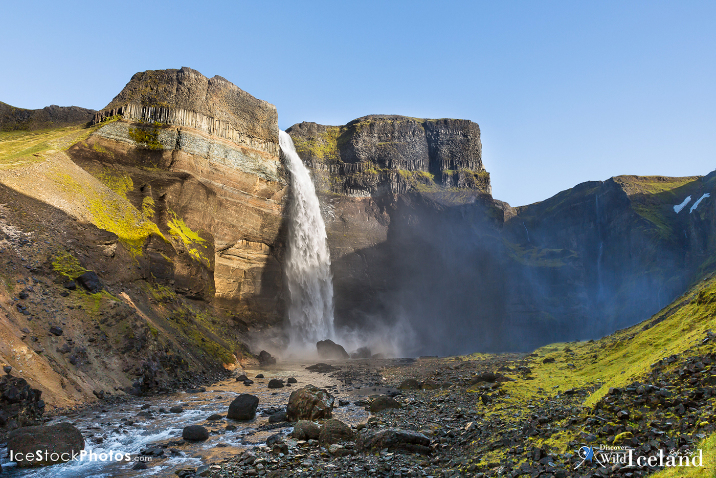
- Háifoss Waterfall
- Háifoss Waterfall
The waterfall Háifoss is situated near the volcano Hekla in the south of Iceland. The river Fossá, a tributary of Þjórsá, drops here from a height of 122 m.
This is the second tallest waterfall in Iceland
This is the second tallest waterfall in Iceland
All the Icelandic Photos you need: http://www.icestockphotos.com

One from the Icelandic Stock Photo web:
- Kerlingarfjöll, Geothermal area in the highlands
- Kerlingarfjöll, Geothermal area in the highlands
Kerlingarfjöll (1,477 m (4,846 ft)) is a mountain range in Iceland situated in the Highlands of Iceland near the Kjölur highland road. The volcanic origin of these mountains is evidenced by the numerous hot springs and rivulets in the area. And indeed, they are part of a large volcano system of 100km² (38.6 square mile). The volcanoes of the range are tuyas.
The earth is shimmering red in this area because of the volcanic rhyolite stone the mountains are composed of. Minerals that have emerged from the hot springs also color the ground yellow, red and green.
All the Icelandic Photos you need: http://www.icestockphotos.com

One from the Icelandic Stock Photo web:
- Fjaðrárgljúfur Canyon
- Fjaðrárgljúfur Canyon
Fjaðrárgljúfur is a canyon in south east Iceland which is up to 100 m deep and about 2 kilometers long, with the Fjaðrá river flowing through it
All the Icelandic Photos you need: http://www.icestockphotos.com

One from the Icelandic Stock Photo web:
- Moss at Lakagígar (Craters of Laki)
- Moss at Lakagígar (Craters of Laki)
Laki or Lakagígar (Craters of Laki) is a volcanic fissure in the south highlands of Iceland,. Lakagígar is the correct name, as Laki mountain itself did not erupt, as fissures opened up on each side of it. Lakagígar is part of a volcanic system centered on the Grímsvötn volcano and including the Þórðarhyrna volcano. It lies between the glaciers of Mýrdalsjökull and Vatnajökull, in an area of fissures that run in a southwest to northeast direction.
All the Icelandic Photos you need: http://www.icestockphotos.com

One from the Icelandic Stock Photo web:
- Kerlingarfjöll, Geothermal area in the highlands
- Kerlingarfjöll, Geothermal area in the highlands
Kerlingarfjöll (1,477 m (4,846 ft)) is a mountain range in Iceland situated in the Highlands of Iceland near the Kjölur highland road. The volcanic origin of these mountains is evidenced by the numerous hot springs and rivulets in the area. And indeed, they are part of a large volcano system of 100km² (38.6 square mile). The volcanoes of the range are tuyas.
The earth is shimmering red in this area because of the volcanic rhyolite stone the mountains are composed of. Minerals that have emerged from the hot springs also color the ground yellow, red and green.
All the Icelandic Photos you need: http://www.icestockphotos.com
One from the Icelandic Stock Photo web:
- Different angel of Háifoss Waterfall
- Different angel of Háifoss Waterfall
The waterfall Háifoss is situated near the volcano Hekla in the south of Iceland. The river Fossá, a tributary of Þjórsá, drops here from a height of 122 m.
This is the second tallest waterfall in Iceland
This is the second tallest waterfall in Iceland
All the Icelandic Photos you need: http://www.icestockphotos.com

One from the Icelandic Stock Photo web:
- Looking over Stekkholts- and Suðurmýri
- Looking over Stekkholts- and Suðurmýri
Looking over Stekkholts- and Suðurmýri at Biskupstungur. We see the Mountains Stórhóll and Rauðfell in the background. – South Iceland
All the Icelandic Photos you need: http://www.icestockphotos.com

One from the Icelandic Stock Photo web:
- Langjökull Glacier with Hagavatn Lake and the twilight in the background
- Langjökull Glacier with Hagavatn Lake and the twilight in the background
Langjökull (Icelandic for "long glacier") is the second largest ice cap in Iceland (953 km2), after Vatnajökull. It is situated in the west of the Icelandic interior or Highlands of Iceland
Its volume is 195 km³ and the ice is up to 580 m (1,900 ft) thick. The highest point of the ice cap (at Baldjökull at the northern end of Langjökull) is about 1,450 m (4,760 ft) above sea level. In the past, the largest recorded surface area was in 1840.
Langjökull is shrinking quite fast, and some researchers believe that it will disappear in about 150 years if climate change continues at its recent pace.
All the Icelandic Photos you need: http://www.icestockphotos.com

One from the Icelandic Stock Photo web:
- Blue Lagoon Spa
- Blue Lagoon Spa
Far too expensive for Icelanders too dip in.
All the Icelandic Photos you need: http://www.icestockphotos.com

One from the Icelandic Stock Photo web:
- Landmannalaugar Highlands
- Landmannalaugar Highlands
Landmannalaugar is a place in the Fjallabak Nature Reserve in the Highlands of Iceland. It is at the edge of Laugahraun lava field, which was formed in an eruption around the year 1477. It is known for its natural geothermal hot springs and surrounding landscape
All the Icelandic Photos you need: http://www.icestockphotos.com
All the Photos on this page can be bought
on my personal Stock Web - Ice Stock Photos . com
Thousands of high resolution photos from Iceland
on my personal Stock Web - Ice Stock Photos . com
Thousands of high resolution photos from Iceland

