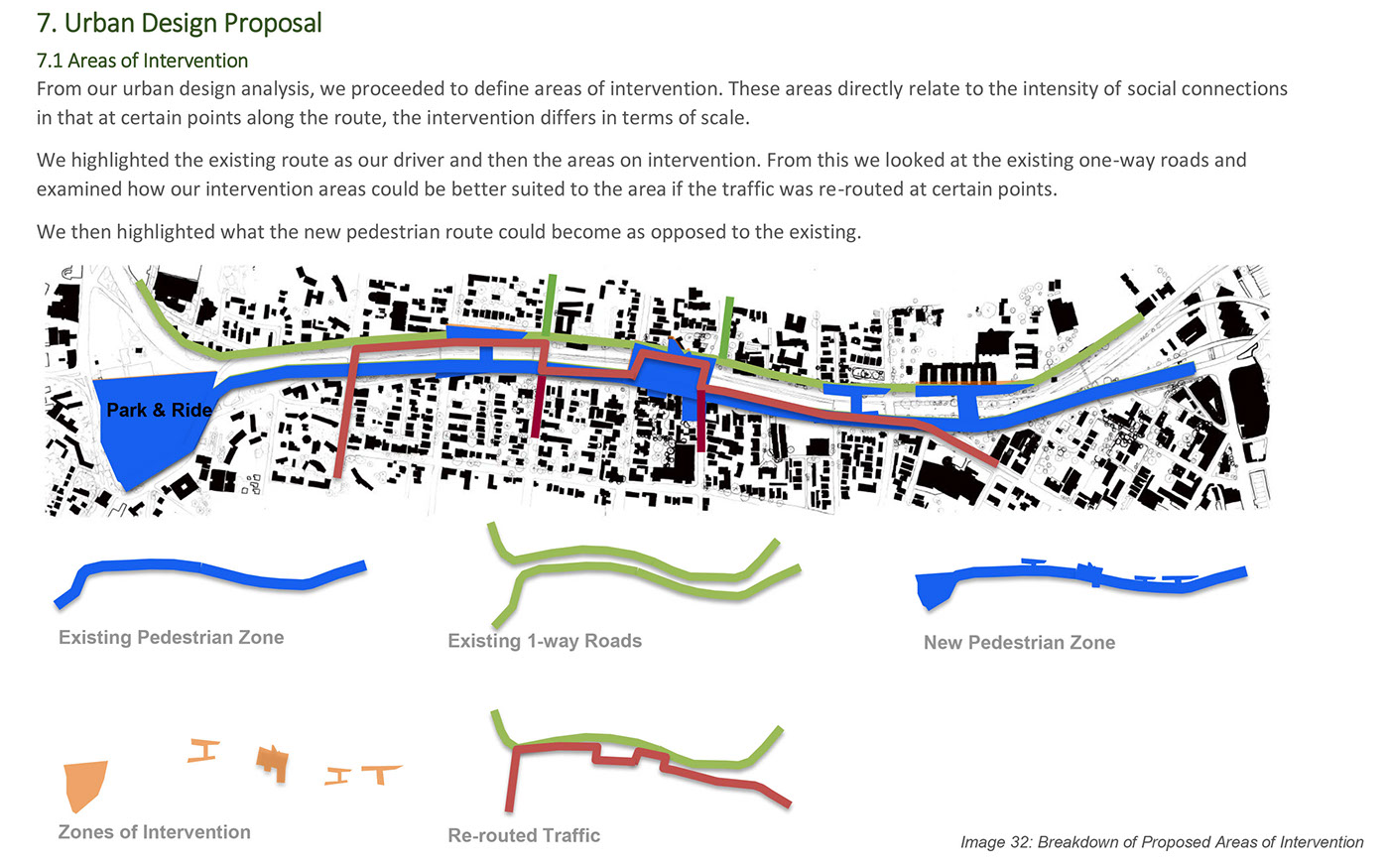
Walk-the-Walk: Masters One_ Urban Redevelopment Project.
As students, we were given the stretch of the N3 in Durban located between Cato- Manor and Warwick Junction. Due to the development of the N3 Highway this area is currently divided and pedestrian unfriendly and as a result many of the properties facing onto this section are falling into neglect or further emphasize the divide by the use of high boundary walls. The aim of this project was to introduce students to urban design by creating a conceptual framework from which this stretch of land can be redeveloped. The main aim was to protect the safety of those +-6000 pedestrians who utilise this stretch of the city to get from their homes in Cato Manor to their places of work within the city. This project was then taken further where the students had to select one parcel of land along the development and design a mixed-use social housing complex.
This project encompassed developing a deep understanding of the user and how theories can be utilised in order to create a meaningful urban planning response. The students were required to spend many hours on site, documenting and interviewing the users.

1.1 A Way Forward:
Historical Background
Cato Manor, named after Durban’s first Mayor, George Christopher Cato, was subdivided in 1914 into a number of small holdings which were sold to landowners, which in turn sold and leased plots to Indian market traders (indentured labourers). These Indian owners, leased out portions of land to Black families who were prohibited from owning land at that time.
In 1948, after the World War 2, the number of informal dwellers in Cato Manor was approximately 30 000. This increase in numbers led to the industrialisation and urbanisation of Durban. The risen economy in Durban caused for more and more informal traders to arise. One of these trading outbreaks was of Zulu traditional Beer.
Indians and Blacks were more in contact with each other due to the working and social lives of using the same land. At the same time, tensions between the two races also grew, due to allegations of overcrowding. This tension led to the Race Riots of 1949.
A summary of the Race riots is as follows:
Indian land owners lost their properties to Black locals after a racial incident, involving stealing and violence, occurred. The result of these riots were the Black traders replacing the Indian landlords.
GROUP AREAS ACT
In 1952, an emergency homeless camp was erected in Cato Manor for homeless blacks.
In 1954, the Group Areas Act was invoked, and Cato Manor was proclaimed as a White area. The Indians and Africans were forcibly removed into areas designated for them viz. Umlazi and Chatsworth.
Riots were met with this proclamation of land, and only years later, was one fifth of Cato manor reclaimed by Indians and Blacks.
References: Website: South African History Online; Article: Cato Manor: Cruel Past, Pivotal Future by Iain Edwards
WARWICK JUNCTION
The area around Warwick Junction was occupied by mixed mainly business and residential uses. As the city’s trade and transport networks expanded it became an important point in the local space economy and a natural market place. Although informal trading had been strictly controlled during the apartheid era, by the early 1990s nearly 4,000 traders were working along the busy sidewalks. The area had been badly neglected and was so rundown that it was described in a local newspaper as a ‘cesspit’. Due to Warwick Junction’s position, on the edge of Durban’s inner city, it plays an integral role in Durban’s public transport and informal traders.
In 1996 the city council launched an urban renewal initiative – the Warwick Junction Project. The project was mandated to focus on safety, cleanliness, trading and employment opportunities, and the efficiency of public transport among other issues.
The Warwick Junction markets accommodates approximately 5000- 8000 vendors throughout the various markets. It’s the largest “informally structured” market place in a public space, and therefor is regarded as the most “authentic” South African market.
Warwick is a prime example of how local informal traders can be successfully incorporated into urban spaces. By understanding the context in which these areas were designed, we can better understand a way in which we can merge them together.
Reference: Website: The creative use of public space in Warwick Junction, Durban, from http://www.rudi.net/books/20057, accessed 11 March 2015

Summary of Site Findings
In summary we observed that there isn’t one continuous path from Cato Manor to Warwick. The route is very disjointed. This divide is made worse by the fact that the paths down from Cato Manor aren’t friendly to pedestrians. The movement is very obstructed by vehicular movement. The edges along the site are harsh and intimidating. We did notice that there was is a specific rhythm to the site that fluctuates throughout the day. We also noted that there is a definite divide between Glenwood and Musgrave and this is due to the N3. We wanted to find out why this division has occurred and how the urban form of Durban has developed over time. Durban was initially founded around the harbor and this resulted in the grid forming parallel to each side of the harbor. The main access road to the harbor is where the N3 now stands and as a result the grids of Musgrave/Essenwood and Glenwood have formed parallel to either side of this route. The surrounding areas of Morning side and the rest of Glenwood has formed essentially as suburbia. Cato Manor itself is a result of Apartheid Urban Planning with very few direct links into Glenwood. These aspects have resulted in this great physical divide not only between Cato manor and Warwick but also between Glenwood and Musgrave Sides as well as a divide between Cato Manor and the city its self. This divide can also be seen in the city block analysis. (figure 1) This analysis also shows the large sizes of the blocks that are not suitable for walkability and further adds to this divide. Zooming into a micro scale we did a figure edge study. (figure 2) This shows that the divide cause by the harsh edges is not really due to the edges of the buildings; it is rather due to the harsh boundary walls that the private buildings along the edge put up. This creates a physical barrier. While we were on site we also interviewed some of the users. They stated that they really only use this direct strip to get from Warwick to Cato manor and the peripheries. They very rarely utilize the immediate edges of the site. Looking at this aspect as well as the grid sizes and how the block sizes have been formed it can be said that this physical divide has resulted in a psychological one as well.
This informed us that the biggest issues that of a lack of physical and psychological connectivity.