
A map of Northern California, centered on San Francisco, from an alternate universe where the USA actually invested in its national rail system instead of letting it rot. Also includes commuter ferries, BART, Muni Metro, interurbans, regional rail, and high-speed rail. Big version here.
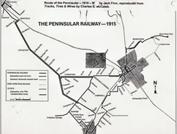
Resources: this BART expansion map, the 1924 Rand McNally maps of California, the 1921 Official Guide to the Railways, this Marin County interurban map and 1937 Bay Area map from the Greater Marin, these Central Valley interurban maps, these 1932 Bay Area streetcar maps, this Peninsular Railway map and service outline, and quite a few local railway historical society websites.

San Francisco

Oakland

San Jose / Silicon Valley

Muni Metro
