
،هليوبوليس هي ضاحية عريقة بقلب القاهرة، وهي تتميز بمنطقة الكوربة التي تعرف بمعمارها الرائع
.ووجهاتها الجميلة و معالمها المتميزة، التي تضفي اليها طابع خاص
.مع الاسف، تظل الكوربة مهملة و تنتقص أي وسيلة من وسائل أرشاد الطرق
شوف هليوبوليس هو مشروع يسعي لتحويل وسائل الارشاد بطريقة مرئية واضحة، لتسهيل حركة التنقل المواطنين
.من خلال خلق تجارب ممتعة للزائرين، مع وضع الفروق الاجتماعية، التعليمية و مختلف مستويات الامية في الحسبان
.هذا المشروع يضم مسارات مبنية علي تفاعلات الزوار في إيجاد الطرق، التعامل مع البيئة المحيطة و أيضاً أهتماماتهم
شوف هليوبوليس يطرح حل لهذه المشكلة عن طريق رسم خريطة وافية محددة للمكان،
،موضحة أهم المعالم و أبرزها. أيضاً طرح هذه الخريطة كخريطة محمولة، و علامات للمحال و المعالم الموجودة بالشوارع
.علامات أرشادية لايجاد الطرق
،موضحة أهم المعالم و أبرزها. أيضاً طرح هذه الخريطة كخريطة محمولة، و علامات للمحال و المعالم الموجودة بالشوارع
.علامات أرشادية لايجاد الطرق
.الخريطة تشجع الزائرين الذين سبق لهم معرفة هليوبوليس طفيفاً لزيارة المكان مرة أخري
،هذا المشروع يهدف لرفع نسبة الوعي بهذه المنطقة الرائعة، و تشجيع الزائرين علي التنزه و خلق ذكريات ممتعة
.وفي نفس الوقت ابتكار نظام لارشاد الطرق بسيط و واضح
-
Heliopolis is a famous, historical part of Cairo with unique a characteristic; the Korba area,
known for its beautiful architecture, facades, and landmarks that give a distinctive identity.
Unfortunately, it is left unattained, neglected, and lacks any navigational systems.
The project aims at visually transforming Heliopolis' way-finding system to facilitate navigation for citizens
by creating experiences, taking into consideration social and educational levels, illiteracy, and languages.
It encompasses journeys that correspond to users' interaction with surroundings,
place perception, interests, and characteristics.
The solution provides a path with directions that highlights landmarks and attractions,
a map, and signs implemented in the streets.
The map encourages users familiar with the place to visit it as it creates memorable experiences,
as well as invite new ones to try it out for the first time and facilitate it.
This design project aims to raise awareness to Heliopolis' historical legacy and motivates users to experience the place.

- Research Phase -
A thorough research was made to properly understand what is way-finding? How do
users perceive their surroundings? How they decipher space around them? And what is the
role of signage to help ease their navigation.
Also a field research was made to better know the district. Its landmarks and the key visual attractions
according to its regular users.

Moodboard

- Decoding -
The following step was to decode the space into different areas;
as shopping places, food, banks etc... as well as highlight the main roads and landmarks.

Street decoding trials


Decoded map trial

- Sketches -
Sketches for landmarks

Saint Cyriel Church

MarMaroon Church

Baroon Ampan's Palace

Woodcut sketchs
- Handheld Map -


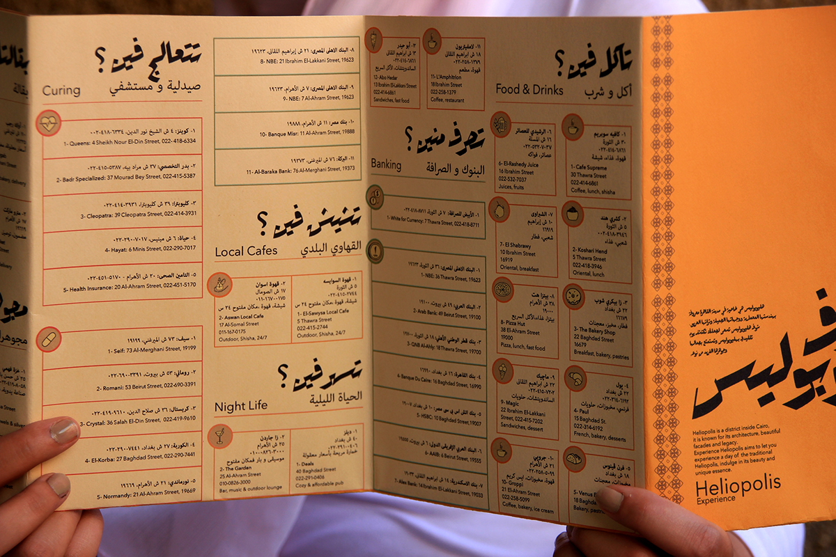
Backside - Detailed information


Backside - Landmarks' Brief

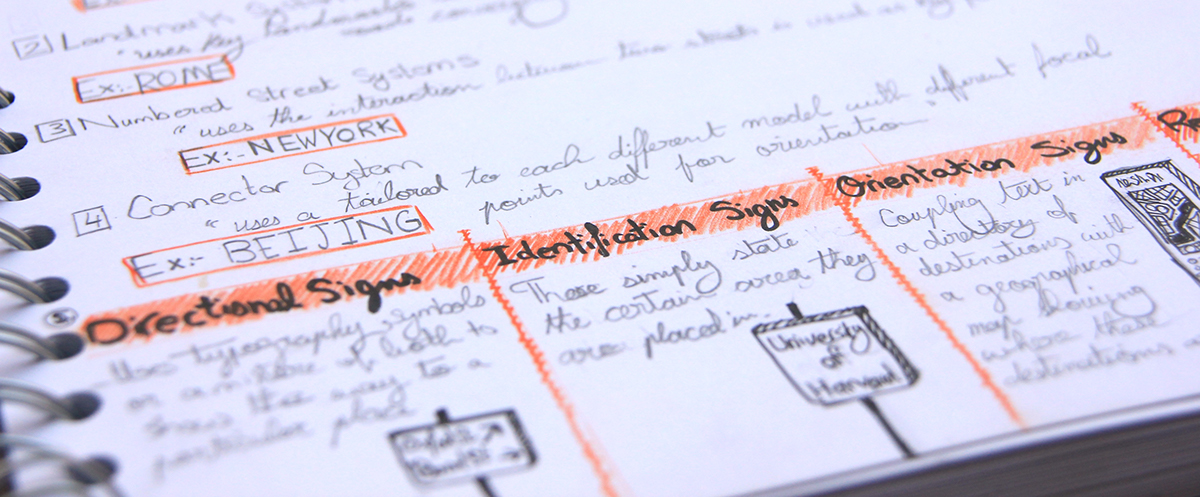
- Street Signage -

Landmark Identification Sign

Landmark Identification Sign

Shop Regulation Sign
Bank Regulation Sign

Street Orientation Sign

Orientation Sign

Orientation Sign


