A collection of transit map projects created for various projects. This page will be progressively updated with new projects as they are completed. (Last update: July 2016)
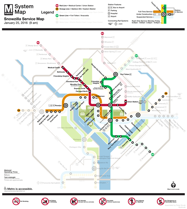
Washington Metrorail "Snowzilla" Service Maps (January 2016)
Maps of the modified service patterns for Washington Metrorail following the January 2016 blizzard.

Unofficial Philadelphia Rail Transit Map (February 2014)
A fictional map of Greater Philadelphia's rapid transit systems. Revised and updated in January 2016.
View more information on this project on its own Behance page.

Greater Baltimore-Washington Commuter Rail Service Map (July 2015)
A map of the two commuter rail systems of the Baltimore-Washington Region.
View additional details including individual service maps on transitoriented.tumblr.com and a feature on the MARC-only map on transitmaps.tumblr.com

River Rail Streetcar Map (June 2015)
A theoretical map redesign of the River Rail heritage streetcar system in Little Rock, Arkansas.
View post on transitmaps.tumblr.com

Taking Transit to the Airport (October 2014)
Illustrating the various methods of reaching the rural airports of the greater Washington area via public transportation.
View post on reddit.com/r/washingtondc

Southbend Southern (June 2014)
A diagrammatic map of my late father's retired model railroad layout, created for a Father's Day present.

Washington Metro Map Redesign (September 2013)
A fictional redesign of the official WMATA Metrorail map. Revised and updated in November 2014.
View more information on this project on its own behance page.

Schematic Metro Track Map (September 2013)
A proposal for a complete track diagram for wayfinding in stations, as an alternative to the current controversial designs.
View post on reddit.com/r/washingtondc | larger resolution

Washington Metro Map To Scale (September 2013)
The style of the official WMATA Metro map applied to a geographically accurate map of the system.
View post on reddit.com/r/washingtondc or find more information on its own behance page here.

Louisville Light Rail Proposal (August 2013)
A map to go along with a theoretical light rail and streetcar system for Louisville, Kentucky.
View more information on this project on its own Behance page.
