This is a concept design from 2015 based on the future appearance of the London Underground network after the opening of the new Crossrail line, using alternative station names and line colours of my own invention. It is based on my ideas about transit map design and how they could be applied to the London Underground network.
It attempts to solve certain issues I perceive with the official existing map produced by Transport for London (TfL), such as the complex representation of the new London Overground network, overuse of accessibility symbols and confusing station names.
The design is based on the projected extent of the network as envisaged by TfL in 2015; it was also inspired by the alternative designs by Max Roberts and a recent article and accompanying video on problems facing the map's future design by Geoff Marshall on the website Londonist.
Please scroll down the page for close-up details and further explanations about the design.
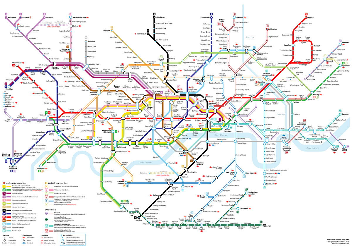
The whole map, designed to fit any standard 'A' size sheet (minimum A4). Click on the image to enlarge.
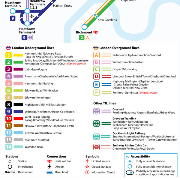
Numerical and alphabeticised lines
My design suggests abandoning the present names for the London Underground lines and recategorising them numerically, in the manner of European metro systems. The numerical order is based broadly on the sequence of dates that the lines were opened or created, from Line 1 (Circle Line, a section of which was opened between Paddington and Farringdon stations in 1863) to Line 14 (Waterloo & City Line, which was incorporated into the Underground system in 1992).
I have created several new lines from existing ones, particular those which have multiple branches: Line 3 from the Uxbridge branch of the Metropolitan Line; Line 6 from the branch of the District Line between Edgware Road and Wimbledon; and Lines 7 and 8, the former given a gold colour, by separating the two branches of the Northern Line.
I have created several new lines from existing ones, particular those which have multiple branches: Line 3 from the Uxbridge branch of the Metropolitan Line; Line 6 from the branch of the District Line between Edgware Road and Wimbledon; and Lines 7 and 8, the former given a gold colour, by separating the two branches of the Northern Line.
I have also given each of the London Overground lines, including those lines projected to be incorporated into that network in 2015 a separately distinguishable colour in place of the presently homogenous orange, and labelled them A-F. Other lines included are the new Crossrail line, the Croydon Tramlink, Docklands Light Railway and the Emirates AirLine Cable Car, each of which are represented by a coloured symbol with the TfL roundel rather than a letter or number.
Station symbols and representing accessibility
The traditional 'tick' marks for stations have been replaced by circles centred on the lines. This is a design detail that TfL presently use for their bus network maps.
The issue of representing station accessibility (i.e., whether stations have step-free access) which appears to be a major preoccupation for TfL's map designers, has been addressed by featuring a simple range of blue or white circles to represent accessibility rather than wheelchair symbols which are becoming increasingly obtrusive on the present map. For a further explanation, see the next image caption.
Symbols
I have included two new symbols: an encircled 'i' to represent locations of TfL Information Centres, and a star to represent a station that is closed on Sundays (presently only Cannon Street). I have retained the National Rail and boat symbols for mainline and riverboat connections respectively, and the dagger symbol to denote a limitation to a service (although I have kept the explanation in the key to a minimum - further information on each affected station could be listed elsewhere).
Typeface
I consider the various derivatives of TfL's famous Johnston typeface that are freely available on the internet to be of poor quality, therefore I chose to use Myriad Pro as a substitute for its clear appearance and legibility.

Interchange symbols
Another important break with tradition is my use of rounded rectangles in place of multiple hollow circles for interchanges. On the present TfL map, certain interchanges appear over-complicated, and here I have attempted to ease that complication with a single circle or rounded rectangle. Where two stations are physically separate but connected, such as Bank/Monument, I have joined them with a single stem (Note also the Liverpool Street/Moorgate interchange with Crossrail).
As explained in the key in the previous image, where an interchange does not have step-free access to every line, accessibility is represented by a blue spot adjacent to the relevant line; where an interchange is entirely accessible, the shape is outlined in blue.
End-of-line stations and destinations
Note that Bank, Liverpool Street, Aldgate and Tower Gateway stations each have line numbers or symbols beside them; these denote the lines which terminate at these stations for ease for visual reference. In addition, these stations and others at which trains usually terminate have their labels set in bold type.
River Thames
The official maps have always avoided allowing text labels to overlap the River Thames, but here I have allowed this in order to ease space constraints.
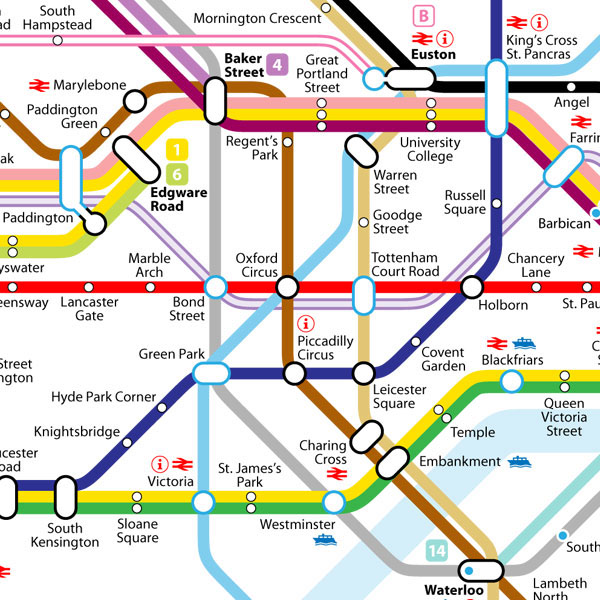
Renaming of stations
Note that 'University College' appears south of Euston instead of Euston Square, and Edgware Road on the Bakerloo line (or line 11) has become 'Paddington Green'. These are two of several stations that I have taken the liberty to rename in order to make them either more relevant to their location, to avoid confusion with other nearby stations, or simply to remove duplicates.
Crossrail
The new east-west Crossrail line through the centre of city has been given a subtle shade of purple in order to reduce its visual disruption of the clean east-west bisecting red line of Line 10 (Central Line).
The new east-west Crossrail line through the centre of city has been given a subtle shade of purple in order to reduce its visual disruption of the clean east-west bisecting red line of Line 10 (Central Line).
Northern Line
Note also that the Charing Cross branch of the present Northern Line is now separate from the other branch via Bank and has been numbered Line 7 and coloured gold.
Other notes
The course of Line 11 (Bakerloo Line) has been drawn to better reflect the geographical positions of Paddington and Regent's Park stations.
Baker Street is designated as the terminating station for Line 4 from Amersham, Chesham and Watford, whilst its other Metropolitan Line spin-off Line 3 continues through to Aldgate.
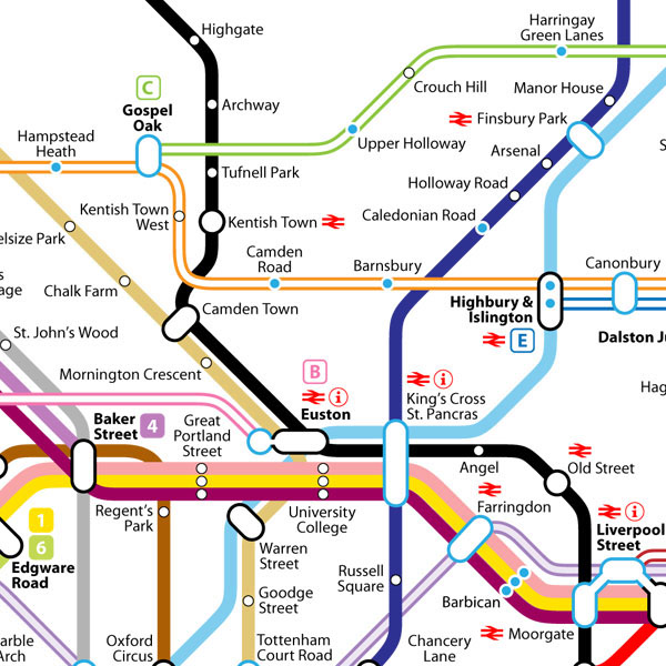
The lines between Camden Town and Euston have been placed at a 45º NW-SE angle to better reflect their relative geographical positions, and to allow more space for text to the north of Euston and King's Cross St. Pancras.
The long-winded Caledonian Road & Barnsbury station has been renamed simply 'Barnsbury'.
The River Lea is included as a distinguishable physical feature in addition to the River Thames. This is intended to alleviate the difficulty in distinguishing geographical locations in an area of the map with many confusingly intersecting lines.
The Gospel Oak-Barking and Liverpool Street-Cheshunt/Enfield Town lines on the London Overground network have been given distinguishable colour schemes.
South Tottenham is placed to better reflect its geographical location to the south of Seven Sisters and Tottenham Hale.
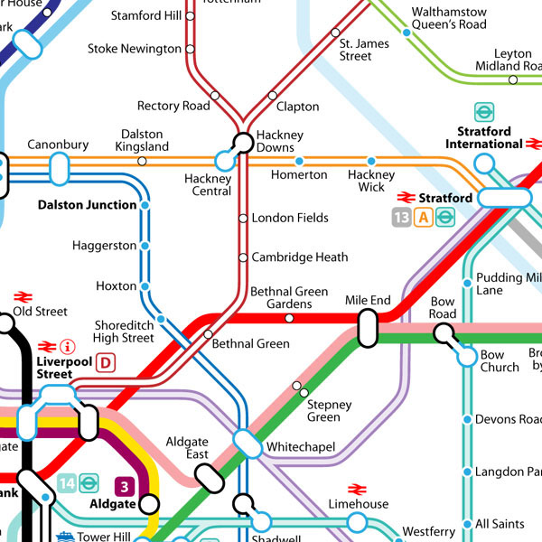
As in the previous detail, the various lines on the London Overground network have been given distinguishable colour schemes.
The issue of two stations sharing the same name 'Bethnal Green' has been addressed here by renaming the Line 10 (Central Line) station as 'Bethnal Green Gardens' due to its proximity to the park of the same name, while the other station on the Liverpool Street Overground Line (Line D) retains its original name. I also considered 'Weavers Fields' as an alternative name for the latter.
The shape of the interchange at Stratford has been simplified.
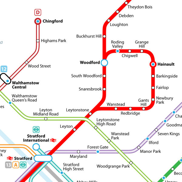
Hainault has been represented as an end-of-line station due to its frequent use as a terminating point for trains on this line.
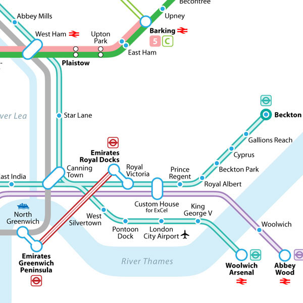
Abbey Road DLR station has been renamed 'Abbey Mills', in reference to the nearby pumping station and to avoid confusion with the more famous Abbey Road in St. John's Wood.
The shape of the River Thames has been drawn to better reflect reality.
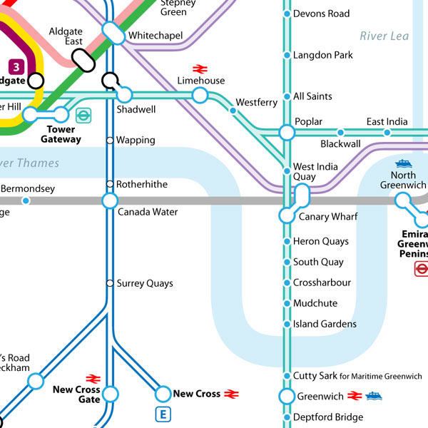
Despite in reality being quite twisting and convoluted, the Stratford-Lewisham branch of the DLR has been drawn as one straight line for simplicity's sake.
Wapping and Rotherhithe stations have been positioned to reflect their proximity to the river, as well as the latter's proximity to Canada Water.
The projected extension of Line 7 (Northern Line Charing Cross branch) to Battersea is shown as 'under construction'. N.B. in reality this is only in the planning stages.
The Croydon Tramlink is displayed as an integral part of the network, albeit without an interchange with Line 8 (Northern Line Bank branch).
The present branch of the District Line between Edgware Road and Wimbledon is shown as a separate line, Line 6.
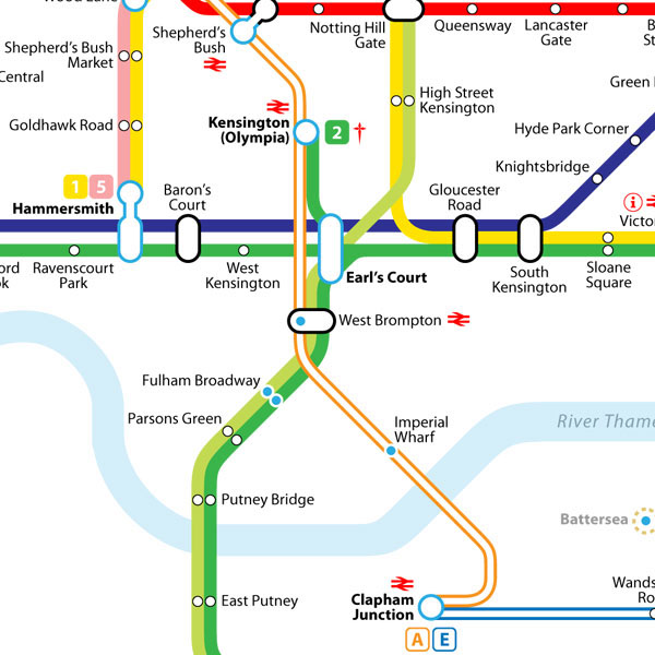
The complicated interchange at Earl's Court is shown with more clarity.

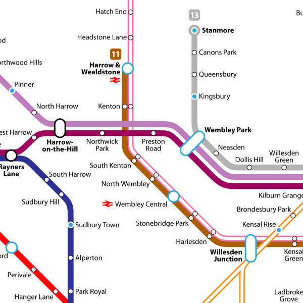
The various lines that pass through this area are shown with little verisimilitude in the present TfL map. The courses of Lines 3 and 4 (Metropolitan Line), 11 (Bakerloo Line) and 13 (Jubilee Line) have been drawn to better reflect their actual relative geography. Resulting improvements include the positions of Swiss Cottage and Chalk Farm and the positions of Kilburn, Kilburn Park and Kilburn High Road in relation to one another.
Brondesbury station's name is confusing as it is generally considered to be in Kilburn (and is on the High Road, less than 50 metres south of Kilburn station on the same street) meaning that the name Brondesbury itself is an anachronism; therefore I have renamed it 'Kilburn Grange' after the nearby park.
The similarly anachronistic Latimer Road has also been renamed, to 'North Kensington'. There is no longer a road in the area by that name.
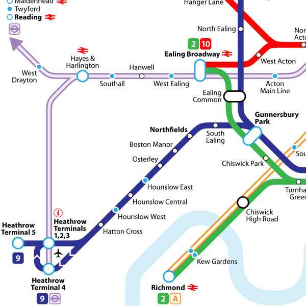
Acton Town has been renamed 'Gunnersbury Park'; this is due to its proximity to that park and therefore better claim to the name 'Gunnersbury', as well as the surfeit of stations with 'Acton' in the name already and the slightly inconsequential name 'Acton Town'. As a consequence, the original Gunnersbury has been renamed 'Chiswick High Road'.
The westernmost stations on the Crossrail line, beyond West Drayton and outside of the London Travel Zones, are listed at the left.
The separation of the present Metropolitan Line into Lines 3 and 4 allow a better representation of the existing service pattern, such as the fact that trains to Amersham, Chesham or Watford often skip Northwick Park and Preston Road. These two stations are shown exclusive to the Uxbridge line.
The course of the London Overground lines through Willesden Junction towards Clapham Junction or Richmond have been simplified.
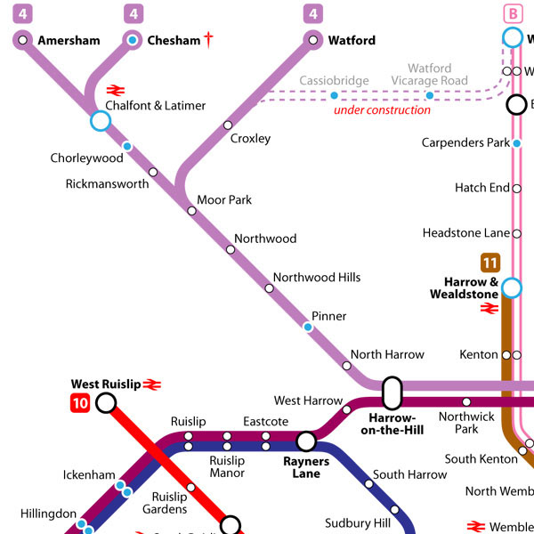
This detail further demonstrates how the Amersham/Chesham/Watford and Uxbridge branches of the Metropolitan Line could be separated into two distinct lines.
The projected extension of Line 4 (Metropolitan Line Watford branch) to Watford Junction is shown as 'under construction'. N.B. in reality this is only in the planning stages.
Comments and suggestions gratefully received at: mike@thisismikehall.com