Bhikaji Cama Place is a District Centre located in South Delhi and is part of a network of 10 such exisitng centres spread across the city. The redesign of the complex entailed conformity to the norms laid down in the Master Plan of Delhi 2021, thereby reducing ground coverage and FAR, increasing the parking to floor area ratio and mainly; a shift in the character of the district centre from a predominantly office oriented complex into a more public oriented commercial centre with city level infrastructure facilities.

City Level Mapping showing existing District Centres in Delhi(in orange) and Bhikaji Cama Place (in red)
In order to derive design cues for the site, a thorough precinct level analysis was carried out in the 1 sq.km vicinity. Factors such as existing infrastructure around the site informed the choice of program components for the new centre.

Precinct Level Mapping showing facilities in the vicinity, as well as the pedestrian and vehicular access designed for the site
Various mapping techniques gave insights into the context and its demands. Green vs. Built equations were analysed, varying population density in the vicinity, vehicular and pedestrian access to the site from all sides and the existing land use pattern of the surrounding areas as well as a gradual shift in the land use pattern in view of the new mixed use policy allowed in the MPD 2021 were taken into consideration.

Context Analysis Maps (clockwise from top-left): Built-Green Relationship; Population Density (X1000 per square kilometers); Site Access-Vehicular and Pedestrian; Land Use Pattern
The site abuts the Ring Road on the north; a heavy traffic, high noise zone. This is the supposed 'front edge' which the city passes by daily. The Africa Avenue on the east divides the site from the neighbouring residential colonies of Nauroji Nagar and Safdarjung Enclave; which have a predominantly semi-detached bungalow character. The road facing bungalows have gradually converted to offices/banks, retail stores and bed and breakfast/business hotels owing to the demand for more commercial space, allowed in the mixed use norms laid down under the MPD 2021.
The Vivekanand Road on the western edge is in proximity to the public and defense buildings, with governent housing in the south west extremities of our study area. This edge of the site is the most dormant in terms of noise, activity and traffic. The southern edge of the site is contained by the urban village of Mohammadpur, which is a high density zone with a wide gamut of activities, namely residential, cottage handicraft, small industrial and informal retail operations being carried out within its extents. The archeologically significant monument; Teen Burji Mosque on the Africa Avenue edge of the village lies in a dilapidated state.
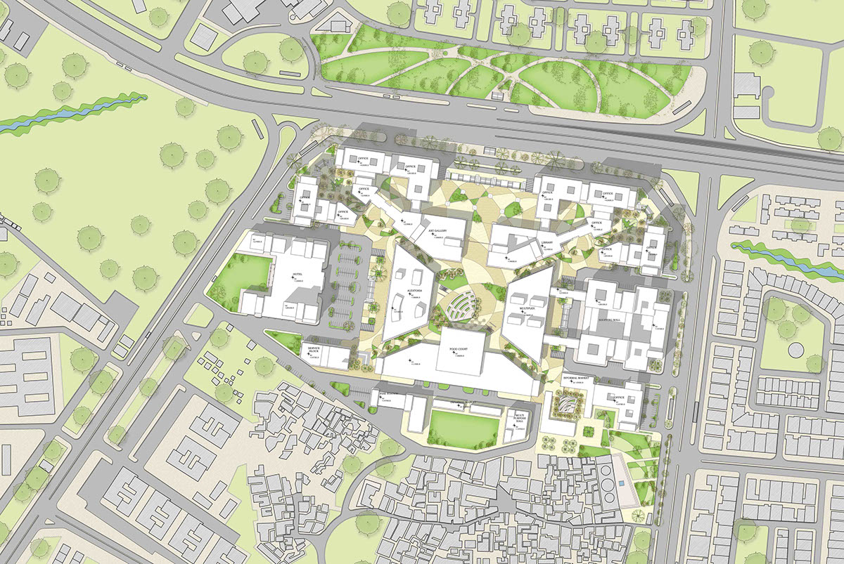
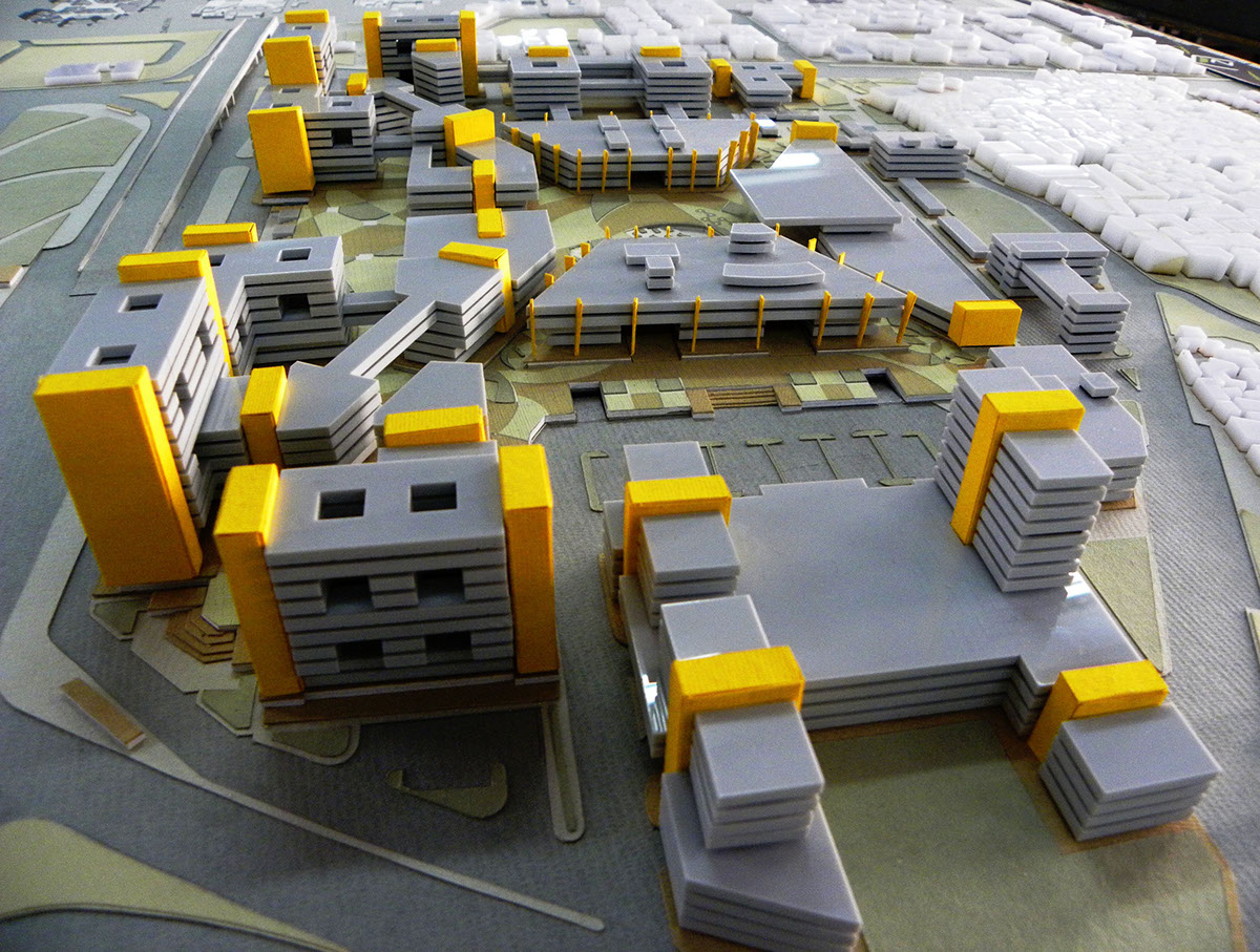
Site Plan
The design aims to create an integrated development that provides city level facilities, being well connected to major transport hubs across the city. The business district character of the site has been retained considering its strategic loaction within the city, although a conscious attempt has been made to promote commercial activity, which leads to an increased public interaction of the district centre on a neighbourhood level. Owing to the introduction of retail, the site stays in use for a longer duration as compared to a predominantly office loaded complex. An attempt has been made to provide the city with a cultural complex by imbibing public oriented functions such as art galleries and libraries, a food court, malls and multiplex, performance theatres as well public open spaces as a major part of the program.
The entire complex has been designed as an exercise in the negative. A site shaped built mass to maintain the edge continuity has been cut, sloped, punctured and distorted to respond to the surroundings and suit the various intents and functions of the design. The site projects the image of a business district to the city with its tall buildings shielding a cultural complex in its midst.
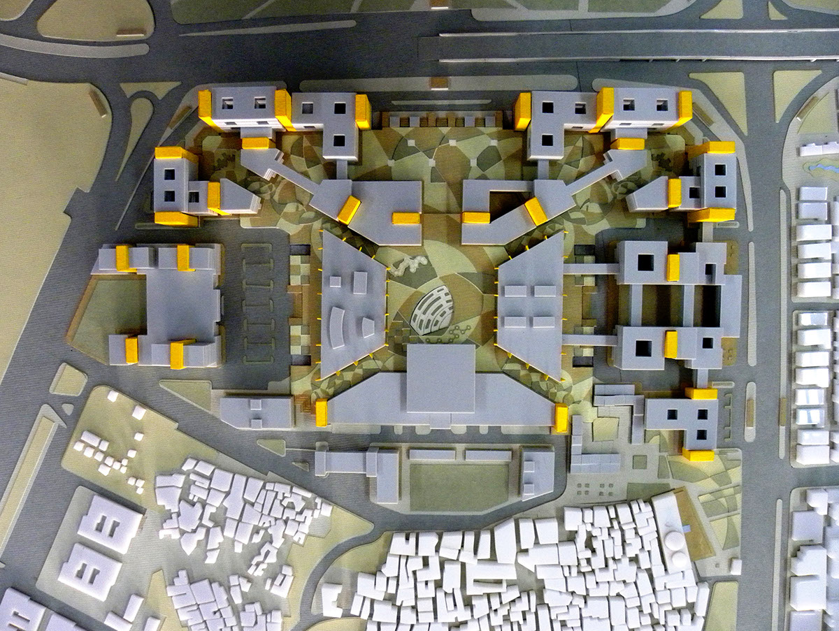
The built massof the complex maintains the edge on the north and east face and gradually opens up on the south and west to accomodate for change in the edge condition

Typical Floor Plan
The built mass on the entire complex has been sloped to the south thereby creating a progression in height as one moves from the village end to the Ring Road. This responds in scale to the village, as the site doesnt impose its presence on the southern edge. Moreover, this allows for deeper solar penetration into the taller office floor plates arranged around internal skylit courtyards.
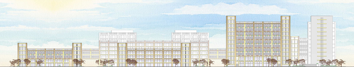
Elevation from Africa Avenue Road

Transverse Section through the public open space, facing the Africa Avenue
The design responds to the context by employing various nuances in the volumetrics to convey opacity, translucence and porosity on each of the four edges of the site. The Ring Road elevation is framed on either side by tall commercial buildings, receding towards the Central Plaza; an inviting entrance gesture allowing views to the interior of the complex.
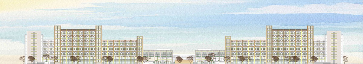
Ring Road Elevation
Pedestrian connectivity to the site has been reinforced by providing underground subways from across the high traffic roads on the north (Ring Road) and east (Africa Avenue). A large unused green buffer space across the Ring Road has been landscaped and an entry to the site has been created by connecting the green to the Central Plaza via a subway.

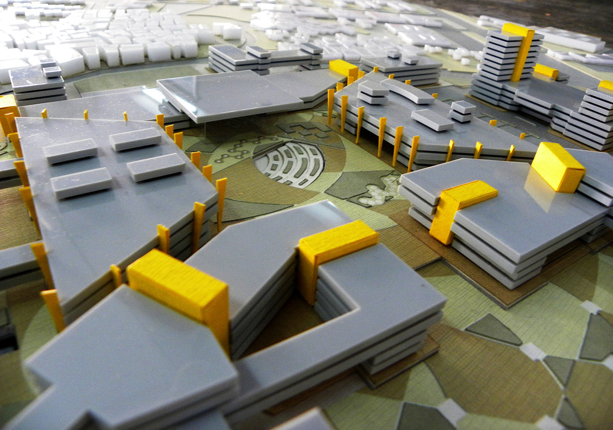
Ground Floor Plan
The north-east and north-west corners of the side, along the Ring Road are created like tall, imposing, opaque faces intended to funnel the pedestrian flow from the city roads onto diagonal shaded, tree lined avenues edged with retail spaces; which dominate most of the ground floor on the site.

Aerial View from the North East corner, showing the 'Retail Avenue' leading to the 'Central Square'
The built envelope on the eastern and western edges of the site have been punctured for vehicular access and drop-off with access to basement parking. Liesure spaces such as the retail mall and Multiplex along the east face are closer to access for the surrounding areas. The quieter western edge is suitable for private functions as the Luxury Hotel, Banquet-ing and Convention Facilities, as well as the Performance Auditoria.
Aerial View from the West; the private end of the site
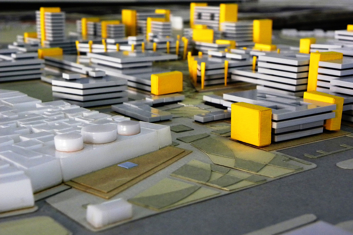
The Central Square : Ensconced by public functions such as the Food Court at the top (facing the Open Air Theatre), the identical Multiplex and Performace Auditoria on the left and right respectively. Other public functions such as the Exhibition Hall and Library form the bottom end of the Square, located at the ground floor of the Commercial buildings. The Central Square acts as the public open space of the site as well as the locus of the city level Cultural Complex it intends to create, with scope for open air performances in the OAT and a space of repose from the hustle and bustle of the city.
Aerial View of the Central Square

Longitudinal Section through the Multiplex and Performance Auditoria
The southern edge of the site faces the densely populated Mohammadpur village. Planned informal markets have been arranged along the south edge and entrance from the Teen Burji side to increase influx into the site; allowing for a fluid access, which is conducive to the low rise high density character of the village. A mulipurpose hall and an open ground provide a much needed public space exclusively for the village, while buffering it from the basemen entry, service access and fire station arranged along a service road.

Aerial View of the complex from the South-West; showing a gradual descent in the volumetric composition as one moves towards the interior of the site and thereby, closer to Mohammadpur Village
The Teen Burji Mosque is an important archelogical site for the city which has fallen into a state of disrepair. The attempt to restore and rejuvinate a piece of city history has been made by scaling down the built form as one approaches the mosque. Moreover, the open area in front of the mosque platform, encroached upon due to immense pressure of urbanisation is restored to a green space, is landscaped and a continuum created with the diagonal avenue by introducing an informal market at this end of the complex.
View of the site from the Teen Burji Mosque; the design scales down to merge with the landscaped court in front of the mosque, thereby creating a welcoming entry point to the site
