The Great Lakes - USA
The Great Lakes contain about 84% of North America's freshwater and approximately 21% of the world's surface freshwater.
The lakes are vital for transportation and trade, with a system of locks and canals allowing ships to navigate between the lakes and the Atlantic Ocean.
The lakes are vital for transportation and trade, with a system of locks and canals allowing ships to navigate between the lakes and the Atlantic Ocean.
I chose to represent this via Absurd Paper Maps in Pro 😅 By John Nelson - Even though it doesn't look like it - 😍
It's really good to understand how to make such a symbology step by step - not only deduction but also how to create it from scratch, you can learn that from here
https://lnkd.in/eqDtK3wy
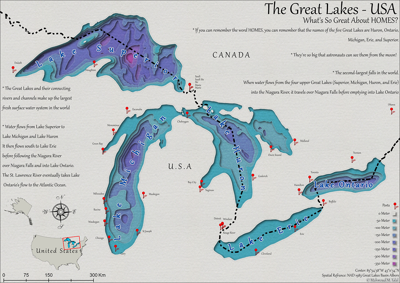
I wanted to manipulate the color gradation between the first color and the last color to highlight the visual contrast to create a smooth transition. I also added international borders - important in my opinion - to highlight that not all lakes are located within the scope of the United States of America this helps provide context and show the geographic extent of the lakes. I also placed the ports that supervise serving the Great Lakes in the form of a 3D symbol, which would make the image more vibrant. I also chose a type A certain set of texts called “Gabriola” makes you feel as if the words were written by hand. this adds a personal touch and enhances the artistic aspect of the map. Finally, I added a map key to the borders of the United States. It looks like an Antique map. this adds a vintage touch and provides a reference for interpreting the symbols and colors used in the map. I derived the final layout from Hanaa Mustafa she has #10_Day_Of_GIS_Map_Challenge
#gis #geographic #geographicinformationsystems #cartography #art #map #mapping #maps #layout #design #arcgispro #usa #unitedstates #america #lake #lakes #greatlakes #depth #colorful #old #antique #canada #freshwater #northamerica #apsurd #paper #papercolor #symbology #multi #layers #colorgradation #ports #3d #symbol #vibrant
It's really good to understand how to make such a symbology step by step - not only deduction but also how to create it from scratch, you can learn that from here
https://lnkd.in/eqDtK3wy
I wanted to manipulate the color gradation between the first color and the last color to highlight the visual contrast to create a smooth transition. I also added international borders - important in my opinion - to highlight that not all lakes are located within the scope of the United States of America this helps provide context and show the geographic extent of the lakes. I also placed the ports that supervise serving the Great Lakes in the form of a 3D symbol, which would make the image more vibrant. I also chose a type A certain set of texts called “Gabriola” makes you feel as if the words were written by hand. this adds a personal touch and enhances the artistic aspect of the map. Finally, I added a map key to the borders of the United States. It looks like an Antique map. this adds a vintage touch and provides a reference for interpreting the symbols and colors used in the map. I derived the final layout from Hanaa Mustafa she has #10_Day_Of_GIS_Map_Challenge
#gis #geographic #geographicinformationsystems #cartography #art #map #mapping #maps #layout #design #arcgispro #usa #unitedstates #america #lake #lakes #greatlakes #depth #colorful #old #antique #canada #freshwater #northamerica #apsurd #paper #papercolor #symbology #multi #layers #colorgradation #ports #3d #symbol #vibrant


