
Maps for The Wheels of Chance by H.G. Wells (Kings Langley Press, 2023)
This pair of antique-style maps was commissioned by Kings Langley Press, an independent book publisher based in Sydney, Australia, for inclusion in their new edition of The Wheels of Chance, a novel by the British author H. G. Wells (1866-1946) originally published in 1896. Featuring a blend of satire and social commentary, it tells the story about a shop clerk named Hoopdriver who takes a bicycle tour of the southern English countryside, making new acquaintances, navigating Victorian societal norms, and gaining insights into his own character along the way.
The first map shows a section of southern England and the circuitous route taken by the protagonist from his home in Putney in south-west London to the New Forest in Hampshire, while the second is a more detailed linear map of the same route showing individual towns and landmarks, divided into six columns in the style of maps by John Ogilby (1600-1676).
The book is now available to order from the Kings Langley Press website.

The front endpapers of the book, featuring the map of southern England

The rear endpapers of the book, featuring the linear route map

The book's cloth-bound cover, featuring an illustration by Nikolay Fomin.
Map 1: Map of Southern England

This map was designed to evoke the style of cartography of the late Victorian period in which the novel is set, utilising carefully chosen colours and period-style typefaces. The protagonist's route is highlighted by a red line.

A detail of the first section of the route from Putney in London along the Portsmouth Road through Surrey. The map shows the road and rail networks, county boundaries and urban conurbations as they were in the 1890s. Historic Ordnance Survey maps were consulted to ensure accuracy.

A closer detail of the route through Guildford and Godalming in Surrey. Land height is represent by hachure lines, which were commonly used in cartography up until this period.

A detail of the route as it passes along the south coast between Chichester and Fareham, with detours to Bognor and Chichester Harbour. A hierarchy of place name labels was established through the use of various period-style typefaces, as seen here where Sybarite Italic is used for major towns and cities and Old Standard for others.

A detail of the final section of the route between Winchester to the New Forest, via Salisbury, Blandford Forum (referred to as "Blandford" in the novel) and Ringwood.

A detail of the map title, legend, scale bar and accompanying illustration of two Victorian characters at the bottom right corner.
Map 2: Linear route map from Putney to the New Forest in the style of John Ogilby

This linear route map is divided into 13 section across 6 columns, starting at the bottom left corner and continuing in an upwards direction up each column and then right along the page, ending at the top right corner. The orientation of each section varies, with each rotated to point vertically in the direction of travel. The format is based on the road maps in John Ogilby's Britannia atlas (1675).

A detail of the bottom left part of the map showing the route's starting point in Putney and the route as it passes through Guildford and Godalming in Surrey. The route accurately follows that which is described in the novel and is represented by roads with thicker black outlines. All roads, railways and built-up areas that appear are also accurate for the 1890s.

A detail of the route as it passes through Cobham and Ripley in Surrey. Landmarks and waypoints mentioned in the novel, most of which are real and some fictional, are pinpointed on the map.

A closer detail of Guildford in Surrey. Small line illustrations of prominent landmarks, some of which are mentioned in the novel, are dotted across the map. Hachure lines are also used to represent hills and changes in elevation, as in the first map.
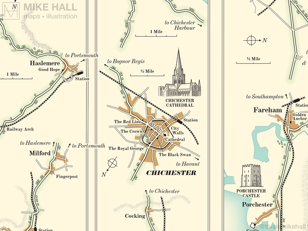
A detail of the central part of the map, showing the route as it passes through Milford and Haslemere in Surrey, Chichester in Sussex, and Portchester and Fareham in Hampshire.

A detail of the top right part of the map, showing the route as it passes through Blandford (known today as Blandford Forum) in Dorset, and the final section of the route where it ends at the Rufus Stone, the monument that marks the place where King William II (c.1056-1100) was allegedly killed by an arrow in the New Forest.

A detail of the bottom right part of the map showing the title and legend, and also part of the route as it passes through Ringwood in Hampshire.
Software used: Adobe Illustrator
Fonts used: Bureau Grotesque, Old Standard, Sybarite, Wide Latin

