MAPS AND PART OF ILLUSTRATIONS
FOR MAX KIDRUK'S BOOK
THE COLONY
IN THE NEW DARK AGES SERIES
FOR MAX KIDRUK'S BOOK
THE COLONY
IN THE NEW DARK AGES SERIES
ABOUT BOOK
The year is 2141.
The year is 2141.
Humanity on Earth has not yet recovered from the clodis disease, which led to the largest pandemic in half a century, when a new pathogen appears that infects only pregnant women. A group of immunologists is trying to find out what it is and whether its appearance is related to the neutrino flares recorded around the planet.
The population of the Martian Colonies exceeds one hundred thousand inhabitants, and a third of them were born on Mars. They are losing out to super-specialists from Earth in the struggle for jobs in the knowledge-intensive economy of Mars and are forced to work like slaves in low-skilled manual labor. The more they come of age, the more they yearn for change, not realizing that this change threatens the very existence of the Colonies.
"The Colony is the first book in the New Dark Ages fantasy series about the world in the twenty-first century. This is a story about how man, despite all his achievements, does not change, and neither an increase in life expectancy nor even the transformation into a biplanetary species guarantees humanity's salvation.
https://darkages.maxkidruk.com/
https://darkages.maxkidruk.com/
HOW IT ALL STARTED
The famous writer Max Kidruk himself tweeted the best thing about the beginning of our work. I'm just going to quote him here, and you can read it directly from his Twitter account. I can't describe it better!
The famous writer Max Kidruk himself tweeted the best thing about the beginning of our work. I'm just going to quote him here, and you can read it directly from his Twitter account. I can't describe it better!
I first contacted the cartographer Fedir Gontsa on June 18. The initial idea was to buy color maps of Mars (similar to those in the Mars Atlas that my wife brought me from America) and draw the Colonies on top of them. This option seemed to me the most realistic. Instead, Fedir suggested that I take the trouble to look for orthographic projections of the Martian terrain that could be visualized in 3D. Until that moment, I had no idea that they existed, but I agreed to take the trouble.
The search lasted for a month, and on July 22, Fedir finally got the 3D terrain of Mars. 11 gigabytes of data scanned by the Mars Orbiter Laser Altimeter (MOLA), one of the five main instruments of the Mars Global Surveyor research probe.
I don't think I emphasized this enough in my previous posts, so I'll emphasize it again: the master plans for the Colonies in New Dark Ages are based on _real_ Martian terrain. Of course, the Colonies themselves don't exist (yet), but if any of you ever find yourself at that point...
...the Chrysus Plain, where, say, Newborn is located, you will definitely recognize the chains of hills around you and the plateaus with steep slopes in the distance.
Isn't it cool?
Since July, we have not stopped working on our plans. I described the settlement, Fedir selected residential and infrastructure buildings according to my requirements and filled in the areas of the topographic map with them. And so on for six months. We were constantly rebuilding, moving, adding something new, and visualizing, visualizing, visualizing.
I came up with names for the as-yet unnamed terrain elements - the Zubrin Fault, the Dragon Mountains, the Cavite de Nanfort lava channels. They fit in perfectly between real names like the Xante Ranges, the Plain of Chrysalis, or the Yala Crater, further blurring the line between fiction and reality…
I came up with names for the as-yet unnamed terrain elements - the Zubrin Fault, the Dragon Mountains, the Cavite de Nanfort lava channels. They fit in perfectly between real names like the Xante Ranges, the Plain of Chrysalis, or the Yala Crater, further blurring the line between fiction and reality…
I would like to emphasize that I did not do the illustrations for the book alone. Kateryna Kosheleva created wonderful illustrations to match the story. Max assembled a big team, the book is very large (900+ pages), complex and fascinating, so I will show here only my part, which complements the overall publication.
You can buy the book in Ukrainian on the official website
https://darkages.maxkidruk.com/
Reviews on goodreads
ISBN 978-617-95267-0-1
https://darkages.maxkidruk.com/
Reviews on goodreads
ISBN 978-617-95267-0-1
FINAL RESULT
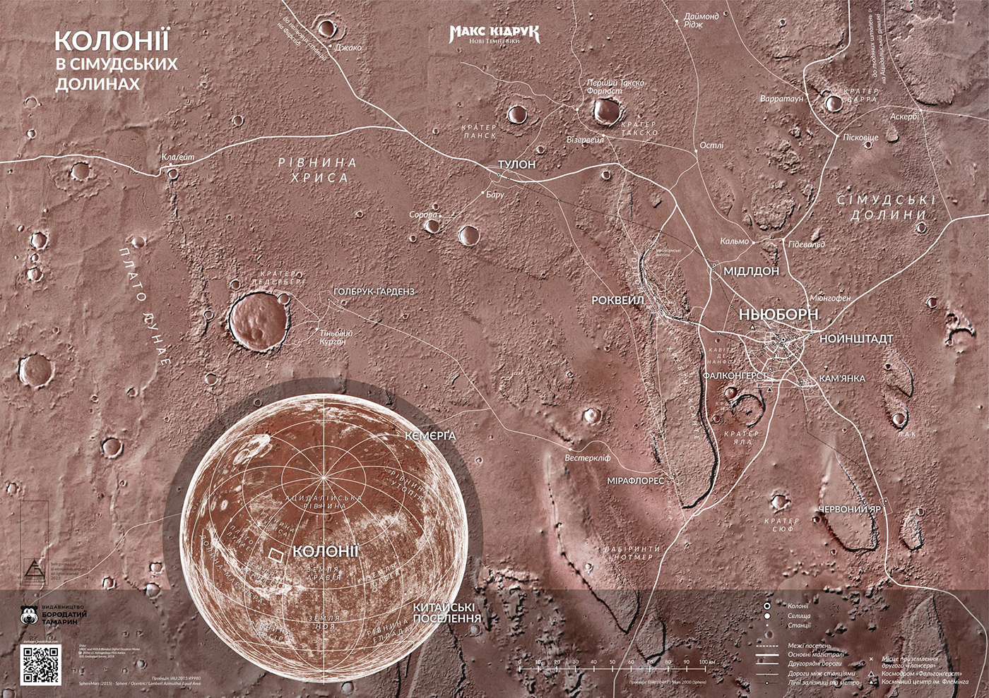
In the book, a map of all the colonies in the Simud valleys is presented in black and white (this map was printed together with the text on the spread of the pages).
In the book, a map of all the colonies in the Simud valleys is presented in black and white (this map was printed together with the text on the spread of the pages).

Maps of the main settlements of the Colony were presented in color, on a special insert in the book, along with perspective images.

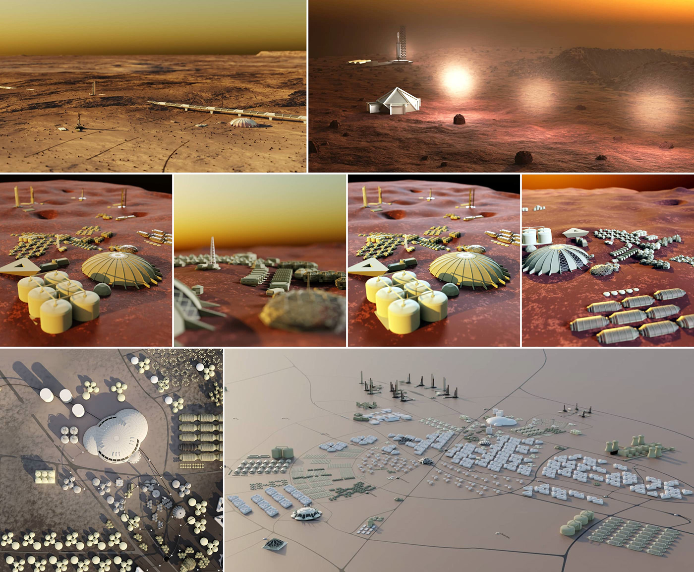
НЬЮБОРН (NEWBOURNE)
It is the largest city in the colony with a variety of functional areas, industrial production, expensive housing stock, and infrastructure development. It is the administrative, cultural and transportation center of the Colony.
It is the largest city in the colony with a variety of functional areas, industrial production, expensive housing stock, and infrastructure development. It is the administrative, cultural and transportation center of the Colony.
КАМʼЯНКА (KAMYANKA)
A functional agricultural settlement that claims to be a city and is built up at the same time. It has a developed cultural component because agronomy on Mars is a highly intellectual business.
A functional agricultural settlement that claims to be a city and is built up at the same time. It has a developed cultural component because agronomy on Mars is a highly intellectual business.

РОКВЕЛ (ROCKVALE)
A large industrial city with a linear layout in the valley of a mountain canyon and silane deposits. Industry alternates with monotonous residential development and large residential multi-functional complexes.
A large industrial city with a linear layout in the valley of a mountain canyon and silane deposits. Industry alternates with monotonous residential development and large residential multi-functional complexes.
THE PROCESS OF CREATION
A large part of this project was downloading publicly available information about Mars, studying geographical projections of the planet. Out of 73 GB of the project, 50 GB is occupied by data about the planet Mars - images, radar scans, nomenclature etc. Mars Viking MDIM21 ClrMosaic global 232m, MARS HRSC MOLA 200m and others.
The entire process of map creation was carried out simultaneously in several programs (among the main ones: QGIS, JOSM, Blender, Inkscape, GIMP), which complicated the process but allowed us to achieve the desired result.


SKETCHES AND RESEARCH OF PLANNING MODELS
It was very difficult to find a visual language, the proportionality of the elements, the correspondence to the description of the locations in the book, and other factors. We tried many, many variants of presentation, and the most interesting ones are presented in this section.
It was very difficult to find a visual language, the proportionality of the elements, the correspondence to the description of the locations in the book, and other factors. We tried many, many variants of presentation, and the most interesting ones are presented in this section.


draft version of map
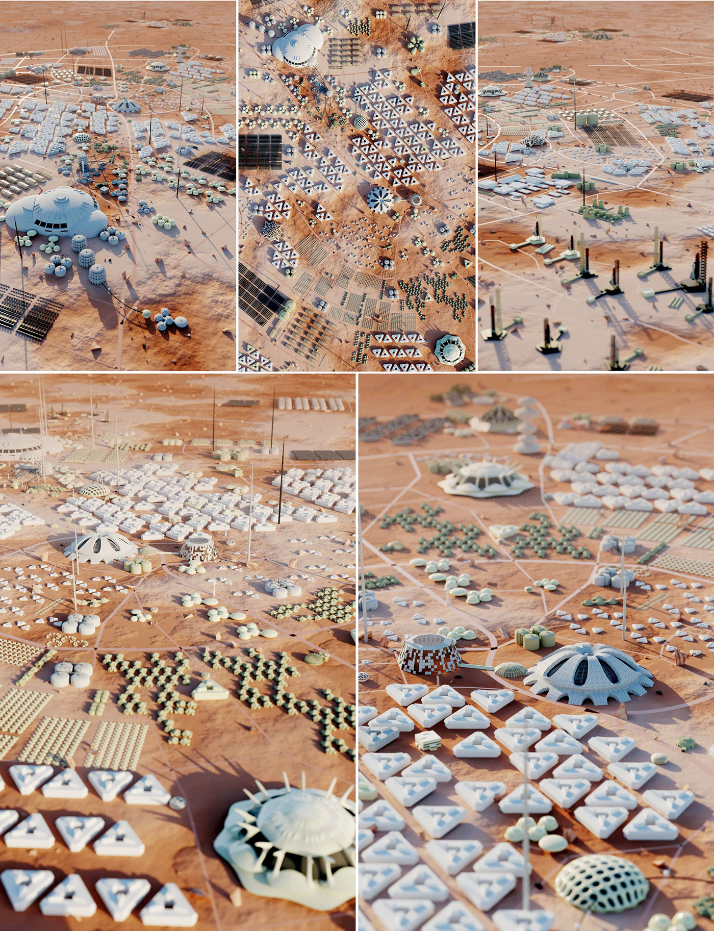
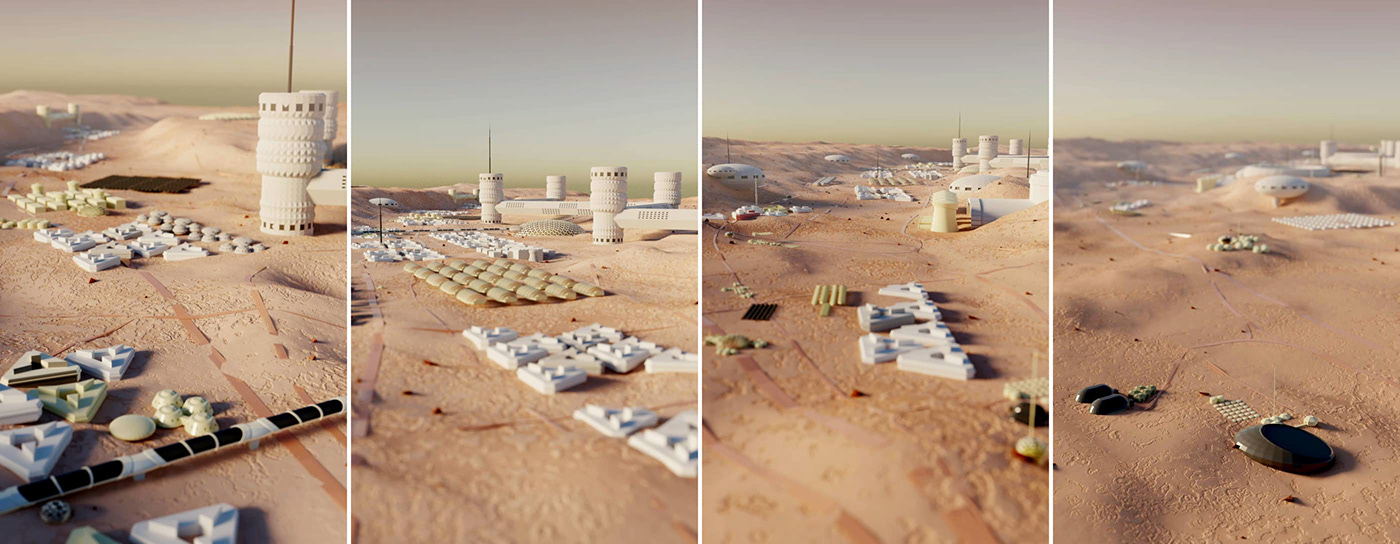
PART OF NEWBOURNE'S ARCHITECTURAL 3D MODELS
To development a plan for the Colony, in addition to planning the actual and functional zoning, I had to create its architecture. I tried to avoid it, but I failed :) These are examples of architectural 3D models of the Newborn colony on Mars in the science fiction book “Colony” by Ukrainian writer Max Kidruk from the series “New Dark Ages”. These models were the basis for the map of the colonies illustrated in the book, and are collected here for example only.
About 55+ unique low-poly models of architecture were created for the Newborn plan (without Rockvale, where is a special architecture). They were also used in numerous combinations to create a diverse and inhabited colony. I tried to collect only unique objects here. Of course, the buildings themselves are very simplified and stylized, as they were the foundation for the map on a rather generalized scale.
3D models of Newbourne arhitecture
Additionally
A1 posters have been created to further promote the book and raise money for drones
for the Armed Forces of Ukraine.
for the Armed Forces of Ukraine.

Poster A1 and A2 Vertical
Poster A1 Landscape

MarsCar in Newbourne
…
That's all!
Thanks for watching my work!
