
INTERACTIVE MARS

Interactive non-linear presentation made in collaboration with Science and Society Synergy Institute and Technology-Innovation Centre Medjimurje.
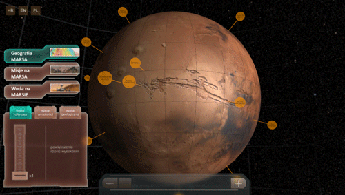
Interactive Mars is a digital globe with many clickable points of interest.
All POIs are arranged in three categories: Geography of Mars, Missions on Mars and Water on Mars.
All POIs are arranged in three categories: Geography of Mars, Missions on Mars and Water on Mars.
Each category has its own map overlay and context menu with cool interactive features like vertical height exaggeration and ocean elevation controls.
Each point of interest is connected to some specific Mars feature and provides information about that feature: geolocation, detailed description, pictures, diagrams, maps and even full interactive panoramas.

main categories

color map

vertical height exaggeration

geological map
vertical height exaggeration animation

full 360 degree panorama made by Opportunity rover

Viking lander gallery

basic information about Mars

map made by astronomer Giovanni Schiaparelli - notice how it is turned upside down

basic info about selected POI

height map and hypothetical Mars ocean

color map visualizing hypothetical ocean coverage based on elevation data

ocean coverage animation

UI textures


Interactive Mars screen-capture
Thank you.


