My #30DayMapChallenge, 2020
This year, as well as 2019, I took part in the best cartographic challenge #30DayMapChallenge where participants from all over the world created beautiful maps on the theme of each day.
Unlike last year, other cartographers from Ukraine also took part in the marathon. The map from Andriy Yaremenko is very interesting and unusual, and maps from some cartographers. As there will be statistics, I will attach it to the publication.
Unlike last year, other cartographers from Ukraine also took part in the marathon. The map from Andriy Yaremenko is very interesting and unusual, and maps from some cartographers. As there will be statistics, I will attach it to the publication.
You can see many interesting and incredible works under the hashtag #30DayMapChallenge on Twitter.
The official repository for #30DayMapChallenge, It is a daily mapping/cartography/data visualization challenge aimed at the spatial community.
I am incredibly grateful to the wonderful Topi Tjukanov from Helsinki, Suomi for organizing this wonderful and much-needed cartographic holiday. Of course, it is difficult to come up with and make a map every day, but it is definitely worth it!
Here are my 30 maps about Ukraine. Enjoy!

Day 01: Points
Speed test Mobile Network data in Kyiv, Ukraine. (2020, quarter 3 / 2020-07-01)
Data: Speedtest by Ookla Speedtest OpenStreetMap contributors, QGIS, SAGA
https://twitter.com/gontsa/status/1322996244655071232
Data: Speedtest by Ookla Speedtest OpenStreetMap contributors, QGIS, SAGA
https://twitter.com/gontsa/status/1322996244655071232
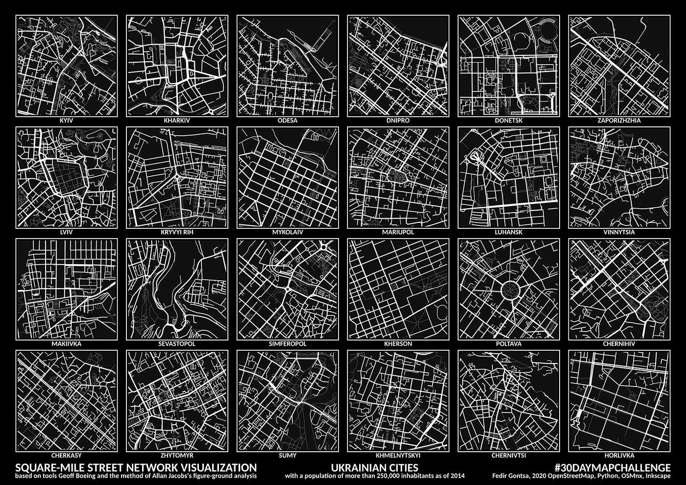
Day 02: Lines
Ukrainian cities with a population of more than 250,000 inhabitants as of 2014.
Square-mile street network visualization.
#30DayMapChallenge Day 02: Lines
tools: Python, OSMnx, Jupyter-lab, Inkscape data: OpenStreetMap
Thank you @gboeing for the excellent tools!
https://twitter.com/gontsa/status/1323189801189842946
Square-mile street network visualization.
#30DayMapChallenge Day 02: Lines
tools: Python, OSMnx, Jupyter-lab, Inkscape data: OpenStreetMap
Thank you @gboeing for the excellent tools!
https://twitter.com/gontsa/status/1323189801189842946
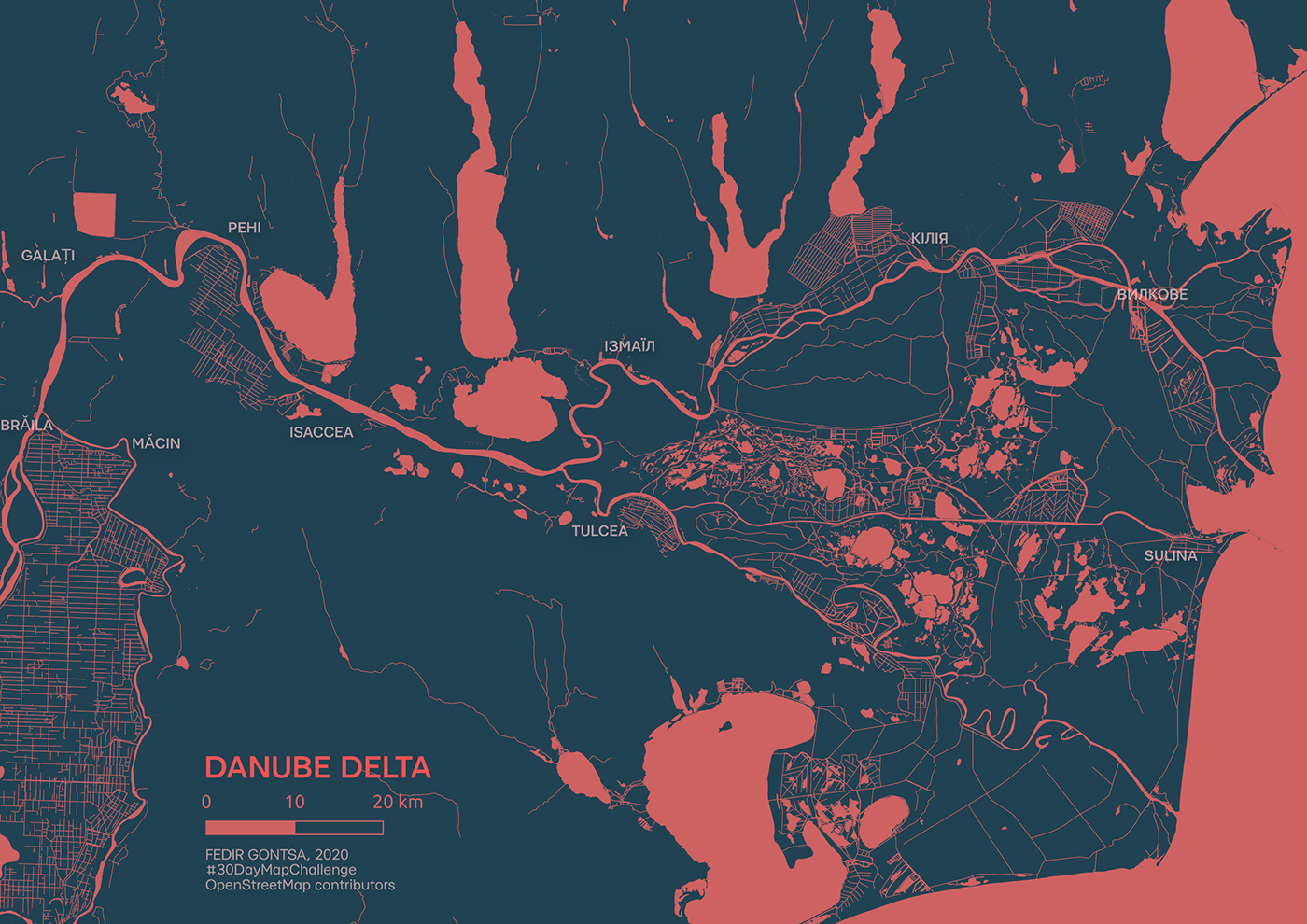
Day 03: Polygons
Danube Delta. The Romania–Ukraine border.
#30DayMapChallenge Day 03: Polygons
lines are also polygons (buffer + merge + dissolve)
Tools: #QGIS data: #OpenStreetMap contributors
https://twitter.com/gontsa/status/1323729096338247683
#30DayMapChallenge Day 03: Polygons
lines are also polygons (buffer + merge + dissolve)
Tools: #QGIS data: #OpenStreetMap contributors
https://twitter.com/gontsa/status/1323729096338247683
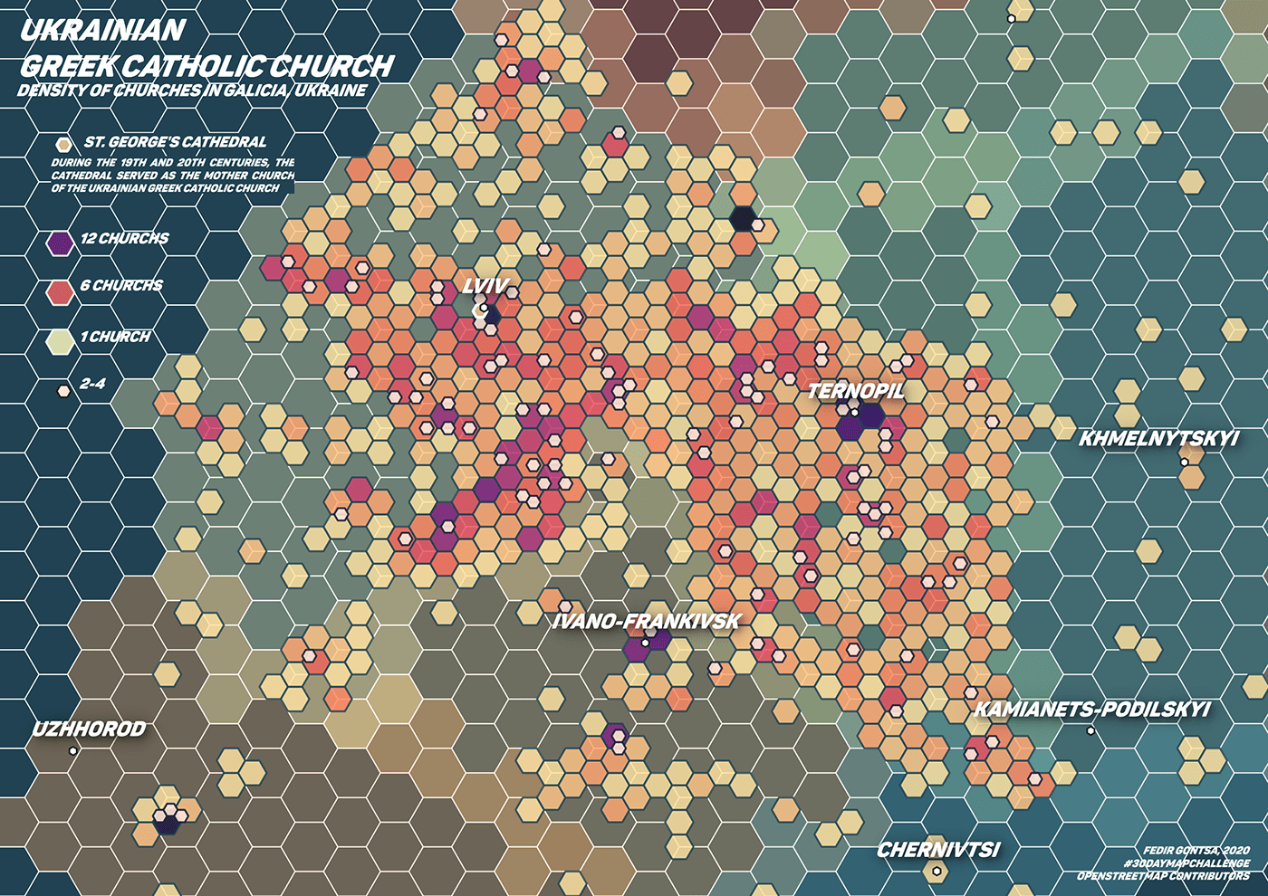
Day 04: Hexagons
Ukrainian Greek Catholic Church in Galicia, Ukraine
#30DayMapChallenge Day 04: Hexagons
#QGIS #OpenStreetMap
In the spring of 2020, we marked more than 1,000 Ukrainian Greek Catholic churches with the @osm_ua community. This is an attempt to visualize this data.
https://twitter.com/gontsa/status/1324051285671350275
#30DayMapChallenge Day 04: Hexagons
#QGIS #OpenStreetMap
In the spring of 2020, we marked more than 1,000 Ukrainian Greek Catholic churches with the @osm_ua community. This is an attempt to visualize this data.
https://twitter.com/gontsa/status/1324051285671350275
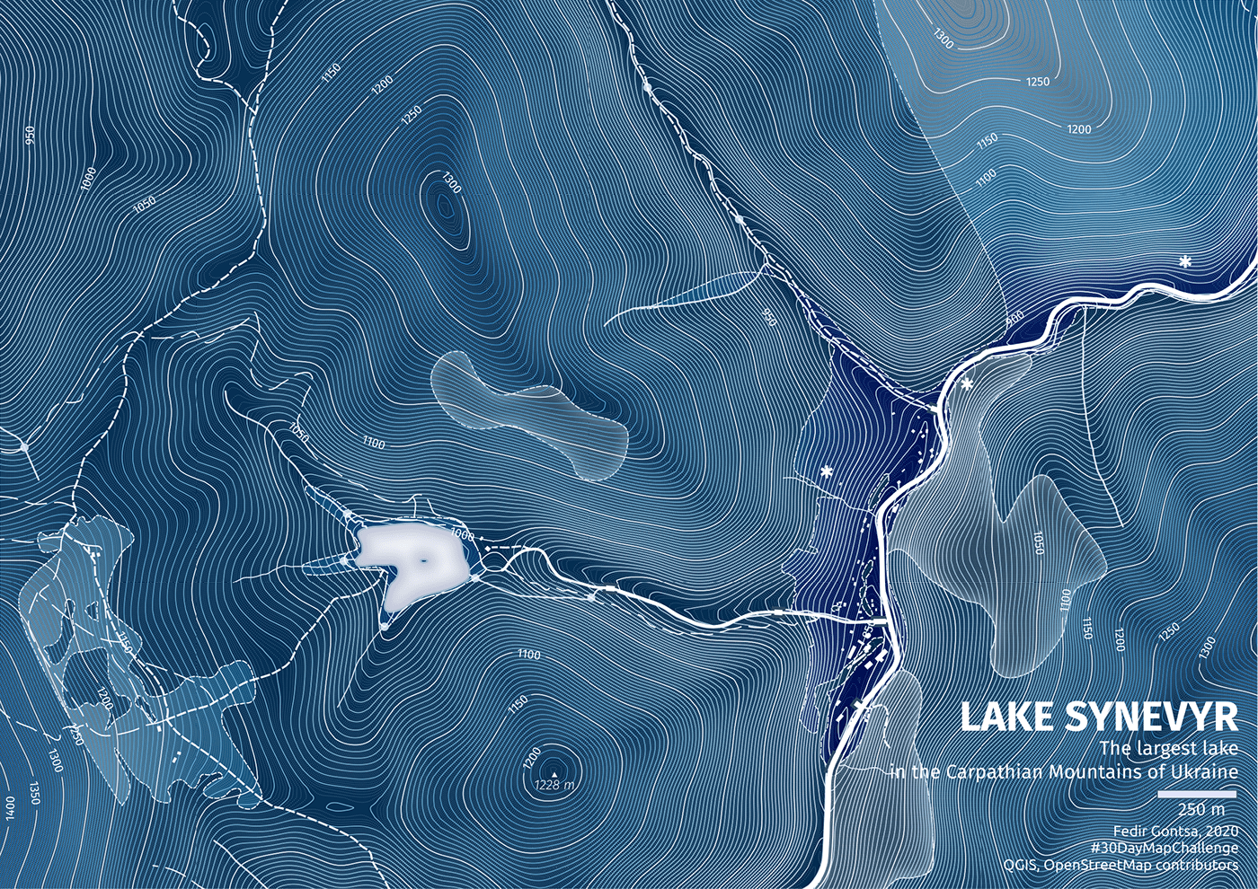
Day 05: Blue
Lake Synevyr is the largest lake in the Carpathian Mountains of Ukraine.
Located at an elevation of 989 meters above sea level.
The name is formed from the words Blue and Whirlpool, the locals also call this lake Sea Eye.
#30DayMapChallenge Day 05: Blue
Tools: #QGIS data: #OpenStreetMap contributors
https://twitter.com/gontsa/status/1324464079927451650
Located at an elevation of 989 meters above sea level.
The name is formed from the words Blue and Whirlpool, the locals also call this lake Sea Eye.
#30DayMapChallenge Day 05: Blue
Tools: #QGIS data: #OpenStreetMap contributors
https://twitter.com/gontsa/status/1324464079927451650
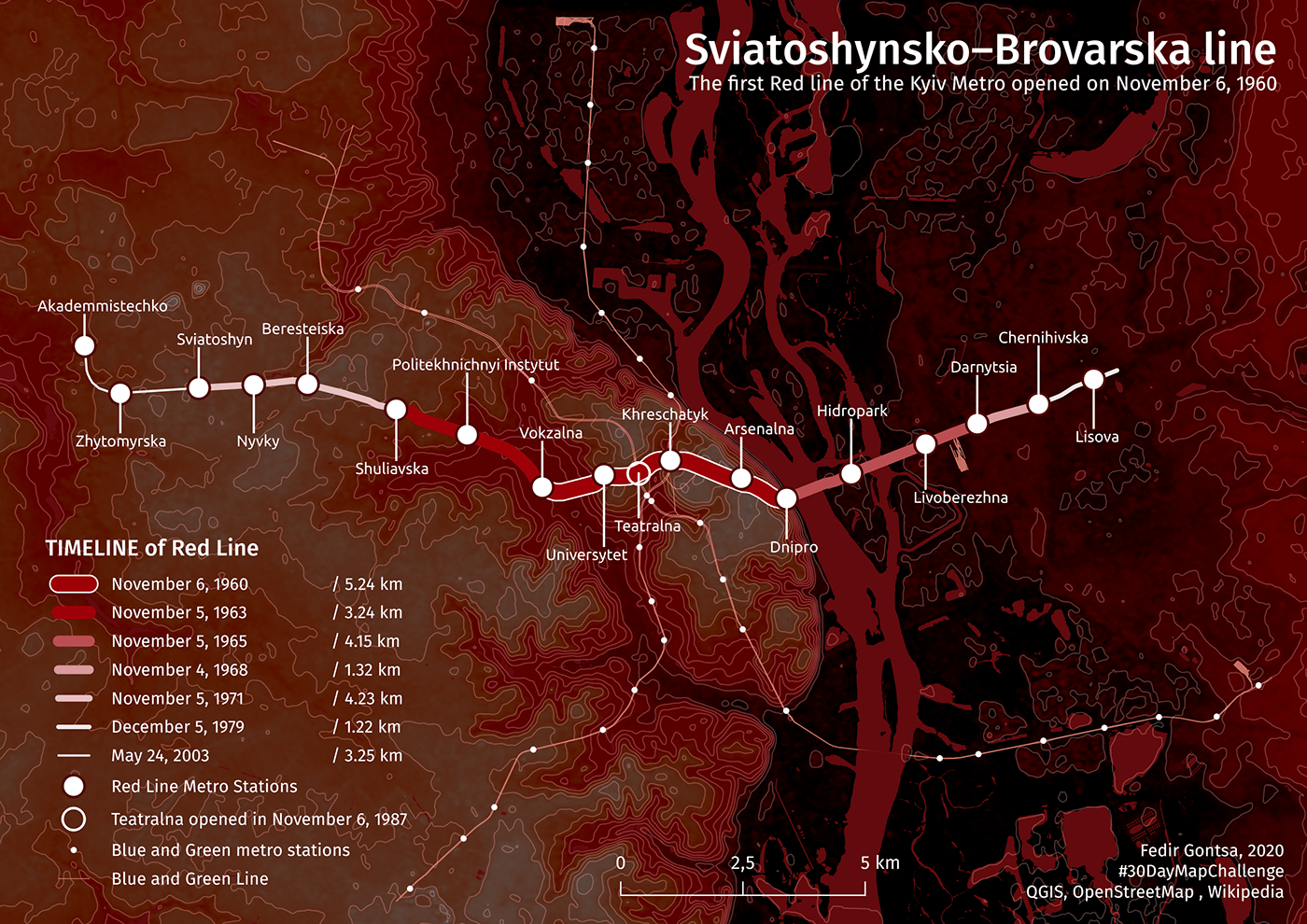
Day 06: Red
Today is the 60th anniversary of the opening of the first (Red) Line of the Kyiv Metro. This map is about the stages of development of the Red Metro Line
#30DayMapChallenge Day 06: Red
Tools: #QGIS data: #OpenStreetMap contributors
https://twitter.com/gontsa/status/1324831586446135297
#30DayMapChallenge Day 06: Red
Tools: #QGIS data: #OpenStreetMap contributors
https://twitter.com/gontsa/status/1324831586446135297
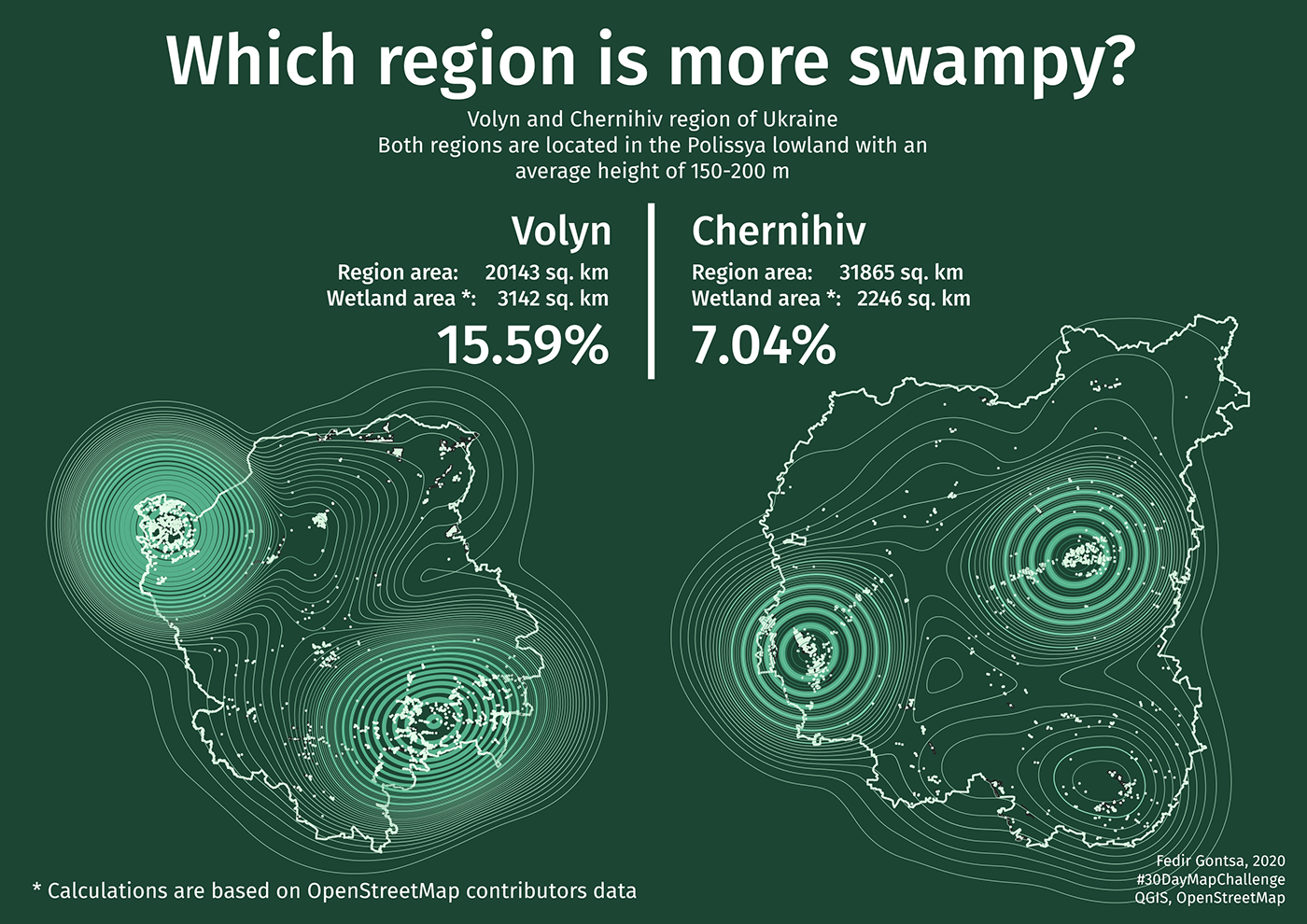
Day 07: Green
Which region is more swampy?
Volyn or Chernihiv
#30DayMapChallenge Day 07: Green
Tools: #QGIS data: #OpenStreetMap contributors
https://twitter.com/gontsa/status/1325195886356361217
Volyn or Chernihiv
#30DayMapChallenge Day 07: Green
Tools: #QGIS data: #OpenStreetMap contributors
https://twitter.com/gontsa/status/1325195886356361217
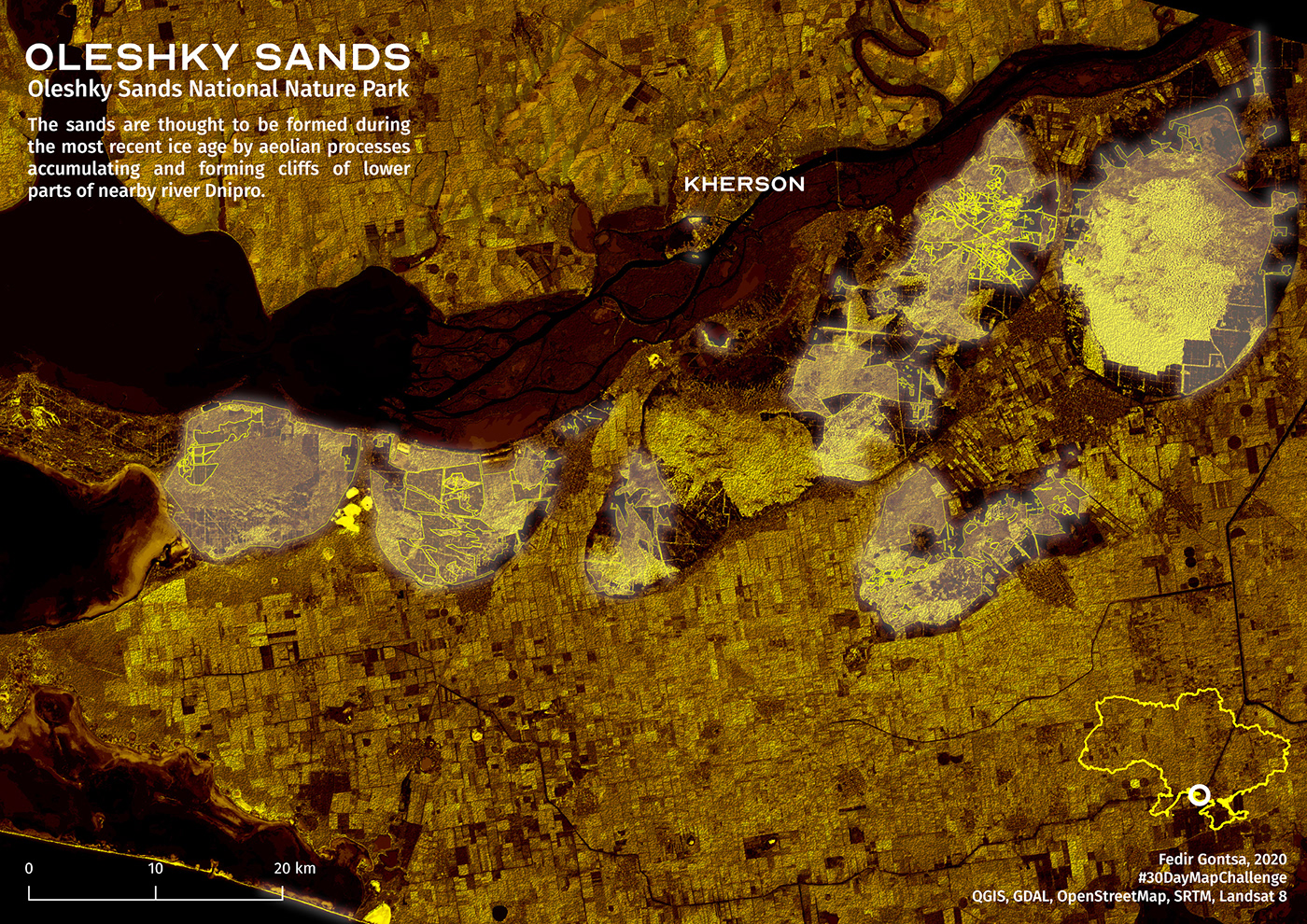
Day 08: Yellow
Oleshky Sands
#30DayMapChallenge Day 08: Yellow
#QGIS, GDAL, #OpenStreetMap, SRTM, #Landsat 8
https://twitter.com/gontsa/status/1325537300680478725
#30DayMapChallenge Day 08: Yellow
#QGIS, GDAL, #OpenStreetMap, SRTM, #Landsat 8
https://twitter.com/gontsa/status/1325537300680478725


Day 09: Monochrome
Part of Carpathian Biosphere Reserve + color variations
#30DayMapChallenge Day 09: Monochrome
#QGIS, GDAL, #OpenStreetMap, SRTM
https://twitter.com/gontsa/status/1325920684061626369
#30DayMapChallenge Day 09: Monochrome
#QGIS, GDAL, #OpenStreetMap, SRTM
https://twitter.com/gontsa/status/1325920684061626369
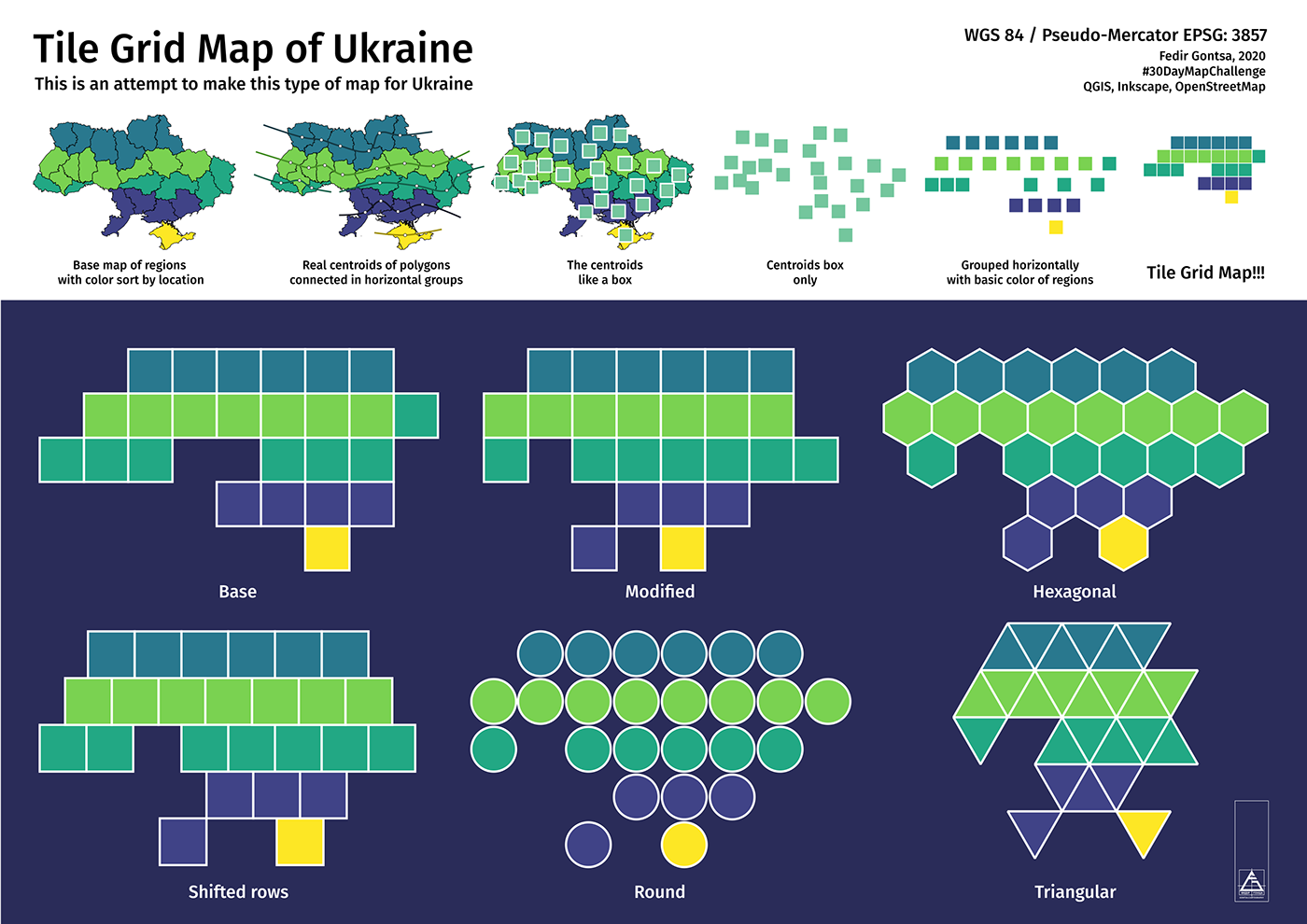
Day 10: Grid
Tile Grid Map of Ukraine
This is an attempt to make this type of map for Ukraine
#30DayMapChallenge Day 10: Grid
#QGIS, Inkscape, #OpenStreetMap contributors
https://twitter.com/gontsa/status/1326265553640546304
This is an attempt to make this type of map for Ukraine
#30DayMapChallenge Day 10: Grid
#QGIS, Inkscape, #OpenStreetMap contributors
https://twitter.com/gontsa/status/1326265553640546304
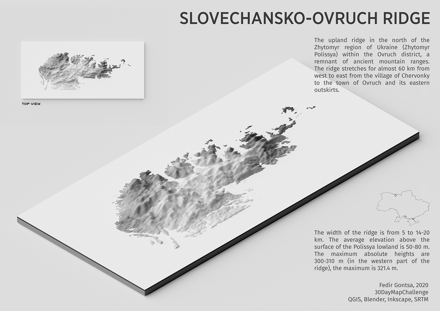
Day 11: 3D
Slovechansko-Ovruch ridge, Ukraine
#30DayMapChallenge Day 11: 3D
#QGIS, #Blender, #Inkscape, SRTM
https://twitter.com/gontsa/status/1326632013357527042
#30DayMapChallenge Day 11: 3D
#QGIS, #Blender, #Inkscape, SRTM
https://twitter.com/gontsa/status/1326632013357527042
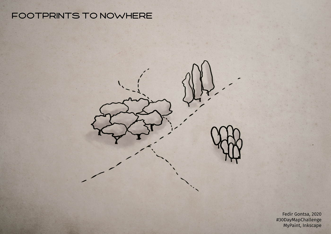
Day 12: Map not made with GIS software
Sometimes we find ourselves in a place that is unfamiliar and incomprehensible to us. We try to find signs that are familiar to us, but they only confuse us. This map is about the relationship between physical and psychological space :)
Where am I?
I once got lost in a plain old park and it was something like that. All guidelines were wrong ;) So this map is about confusion.
Where am I?
I once got lost in a plain old park and it was something like that. All guidelines were wrong ;) So this map is about confusion.
Footprints to nowhere
#30DayMapChallenge Day 12: Map not made with GIS software
MyPaint, Inkscape
https://twitter.com/gontsa/status/1327008336131338249
#30DayMapChallenge Day 12: Map not made with GIS software
MyPaint, Inkscape
https://twitter.com/gontsa/status/1327008336131338249
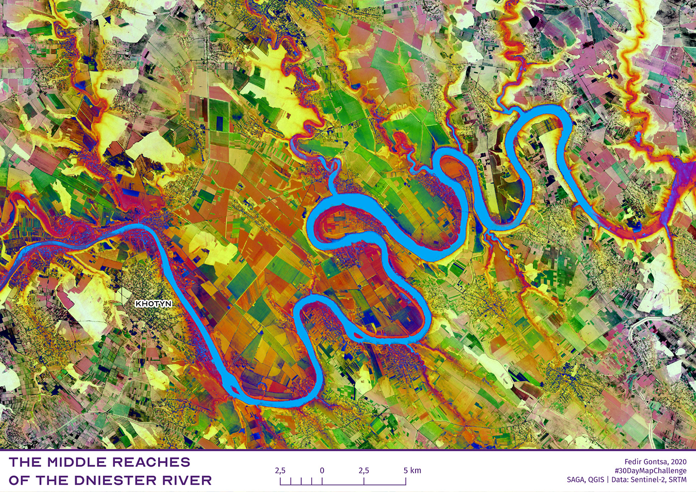
Day 13: Raster
The middle reaches of the Dniester River, Ukraine.
#30DayMapChallenge Day 13: Raster
Tools: SAGA GIS, QGIS. Data: Sentinel-2, SRTM
https://twitter.com/gontsa/status/1327322894871965698
#30DayMapChallenge Day 13: Raster
Tools: SAGA GIS, QGIS. Data: Sentinel-2, SRTM
https://twitter.com/gontsa/status/1327322894871965698
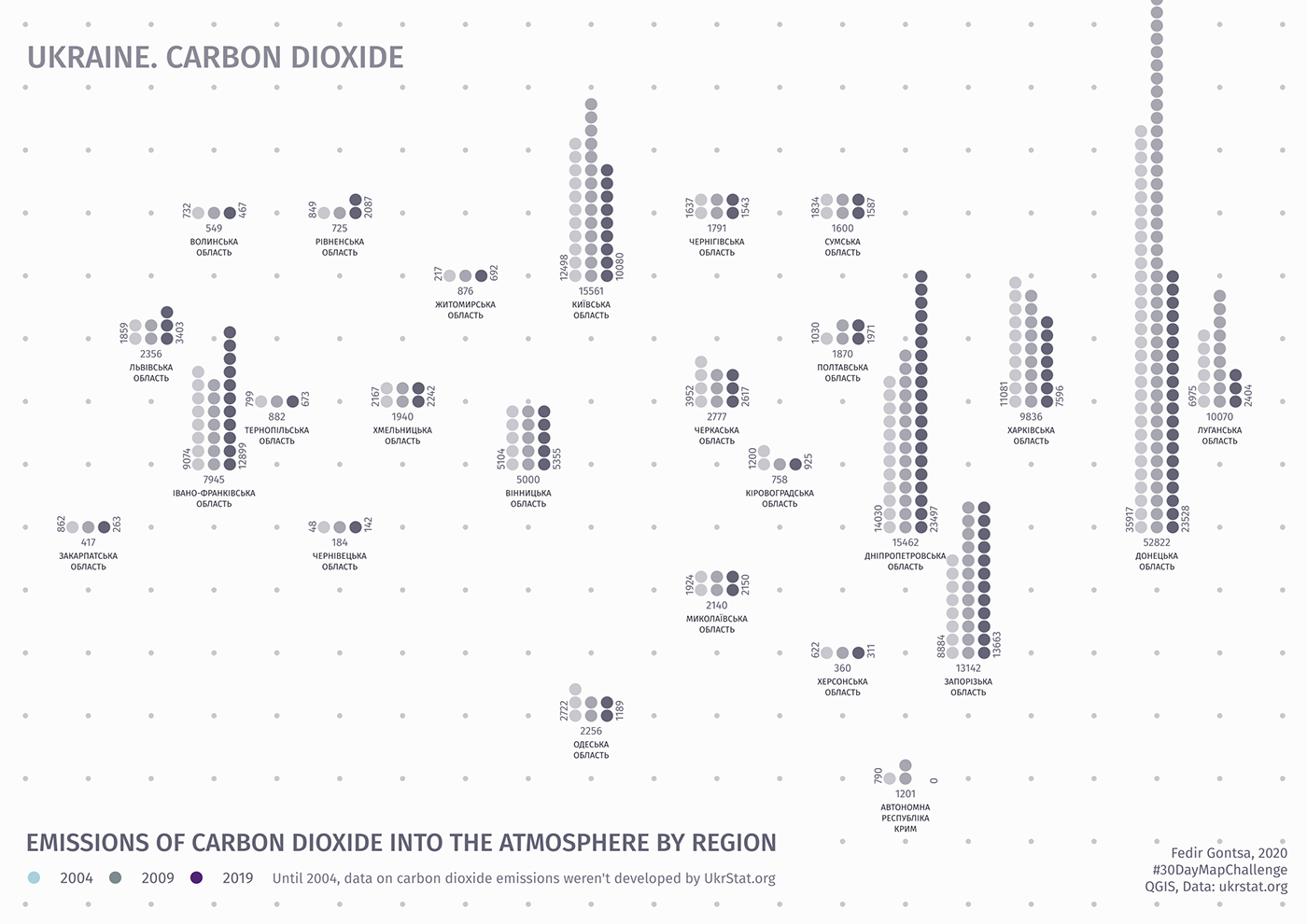
Day 14: Climate change
Ukraine. Emissions of Carbon Dioxide into the atmosphere by region
#30DayMapChallenge Day 14: Climate change
#QGIS Data: UkrStat.org
https://twitter.com/gontsa/status/1327729211054886912
#30DayMapChallenge Day 14: Climate change
#QGIS Data: UkrStat.org
https://twitter.com/gontsa/status/1327729211054886912
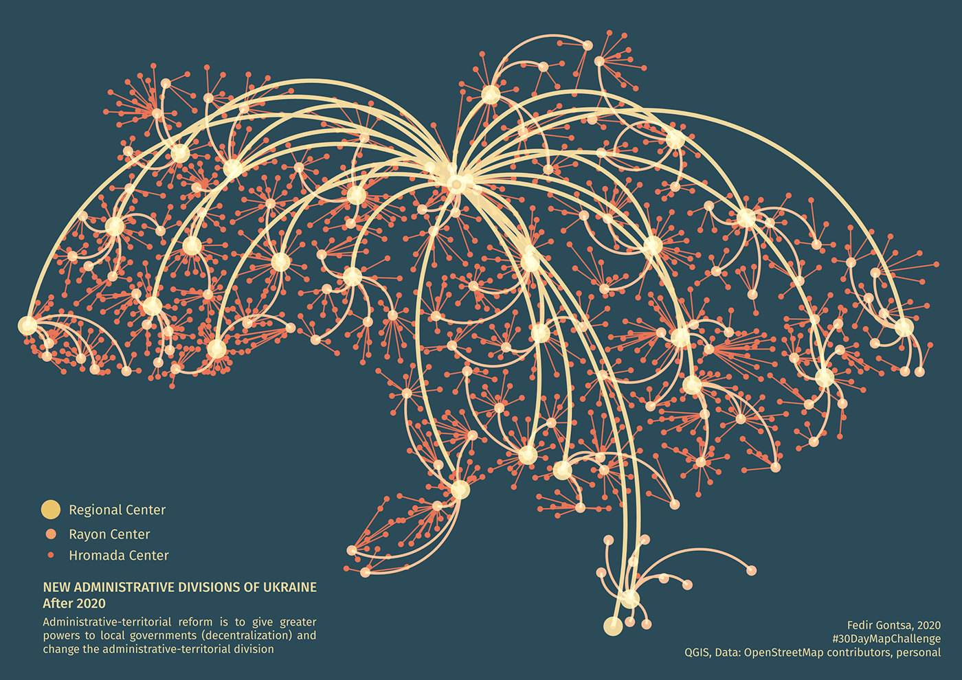
Day 15: Connections
New administrative divisions of Ukraine after 2020
#30DayMapChallenge Day 15: Connections
#QGIS Data: #OpenStreetMap contributors, personal
https://twitter.com/gontsa/status/1328108268972072965
#30DayMapChallenge Day 15: Connections
#QGIS Data: #OpenStreetMap contributors, personal
https://twitter.com/gontsa/status/1328108268972072965
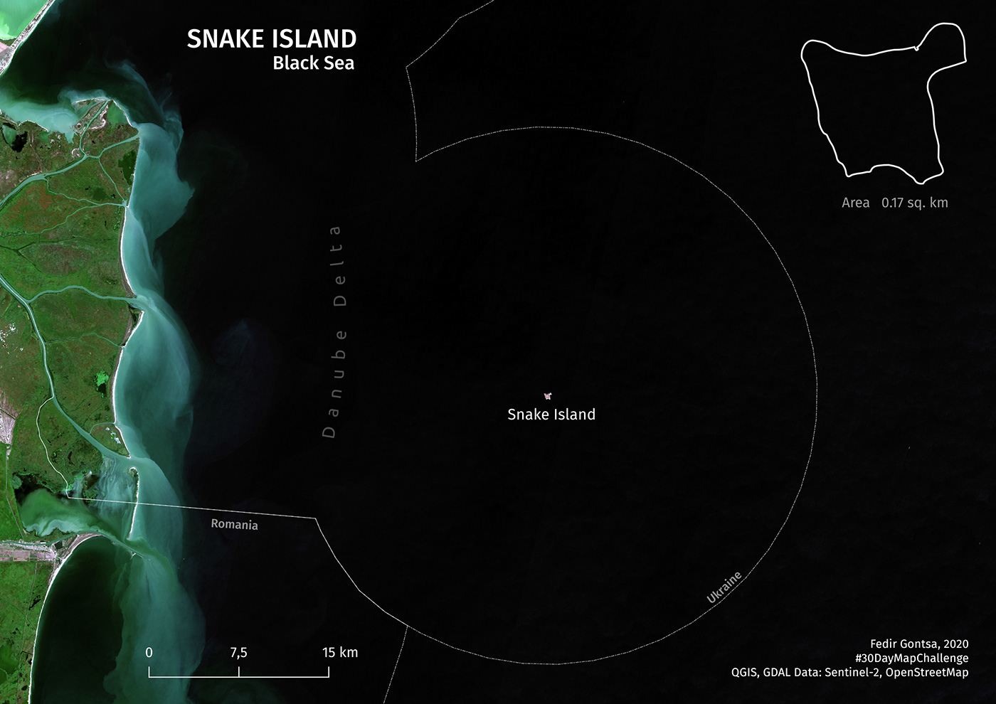
Day 16: Island(s)
Snake Island. Black Sea
#30DayMapChallenge Day 16: Island(s)
QGIS, GDAL Data: Sentinel-2, OpenStreetMap
https://twitter.com/gontsa/status/1328445617622949889
#30DayMapChallenge Day 16: Island(s)
QGIS, GDAL Data: Sentinel-2, OpenStreetMap
https://twitter.com/gontsa/status/1328445617622949889
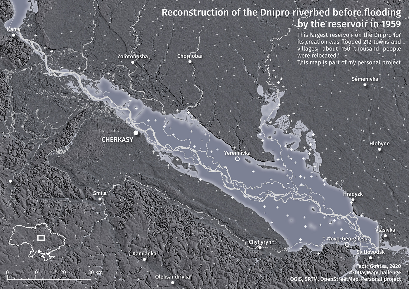
Day 17: Historical map
Reconstruction of the Dnipro river (Ukraine) riverbed before flooding by the reservoir in 1959.
#30DayMapChallenge Day 17: Historical map
QGIS, OpenStreetMap, Old Maps, My Personal project files
https://twitter.com/gontsa/status/1328819605737967619
#30DayMapChallenge Day 17: Historical map
QGIS, OpenStreetMap, Old Maps, My Personal project files
https://twitter.com/gontsa/status/1328819605737967619
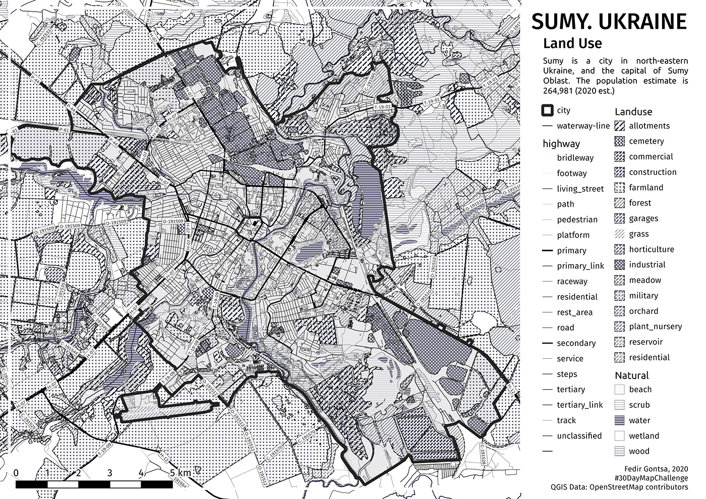
Day 18: Landuse
Sumy, Ukraine. Simple land use plan
#30DayMapChallenge Day 18: Landuse
#QGIS Source: #OpenStreetMap contributors
https://twitter.com/gontsa/status/1329190540114620424
#30DayMapChallenge Day 18: Landuse
#QGIS Source: #OpenStreetMap contributors
https://twitter.com/gontsa/status/1329190540114620424
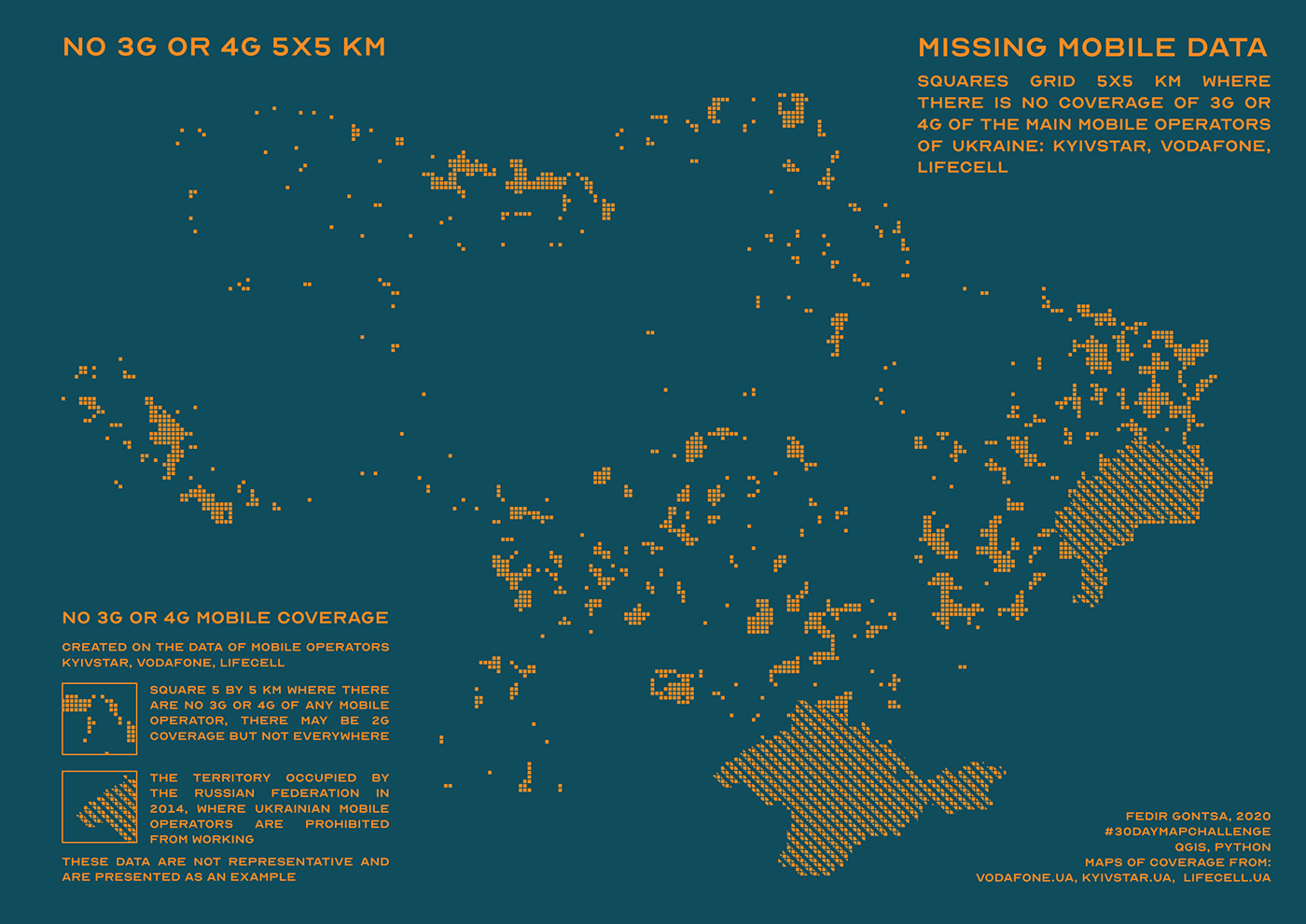
Day 19: NULL
Based on:
https://www.vodafone.ua/services/network/coverage-map
https://kyivstar.ua/uk/mm/mobile-internet/karta-pokrytiya-3g
https://www.lifecell.ua/en/mobile-internet/
https://www.vodafone.ua/services/network/coverage-map
https://kyivstar.ua/uk/mm/mobile-internet/karta-pokrytiya-3g
https://www.lifecell.ua/en/mobile-internet/
No 3G or 4G coverage map in Ukraine.
#30DayMapChallenge Day 19: NULL
#QGIS, #Python, Coverage maps of main mobile operators
Thanks for the map idea @mrpetruccio
https://twitter.com/gontsa/status/1329537476625633282
#30DayMapChallenge Day 19: NULL
#QGIS, #Python, Coverage maps of main mobile operators
Thanks for the map idea @mrpetruccio
https://twitter.com/gontsa/status/1329537476625633282
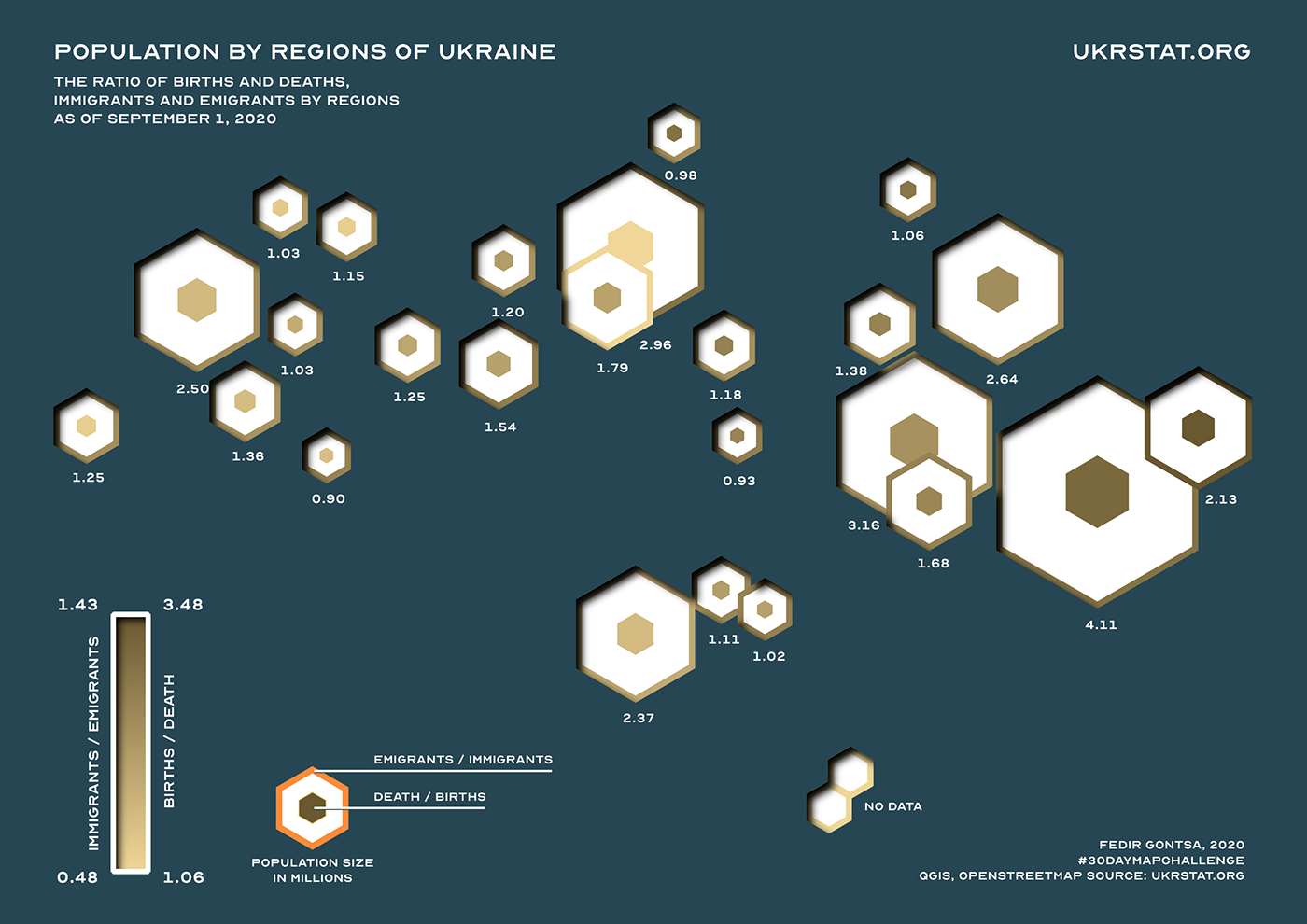
Day 20: Population
Population by regions of Ukraine. The ratio of births and deaths, immigrants and emigrants by regions
#30DayMapChallenge Day 20: Population
#QGIS #OpenStreetMap contributors Source: ukrstat.org
https://twitter.com/gontsa/status/1329920326650785794
#30DayMapChallenge Day 20: Population
#QGIS #OpenStreetMap contributors Source: ukrstat.org
https://twitter.com/gontsa/status/1329920326650785794
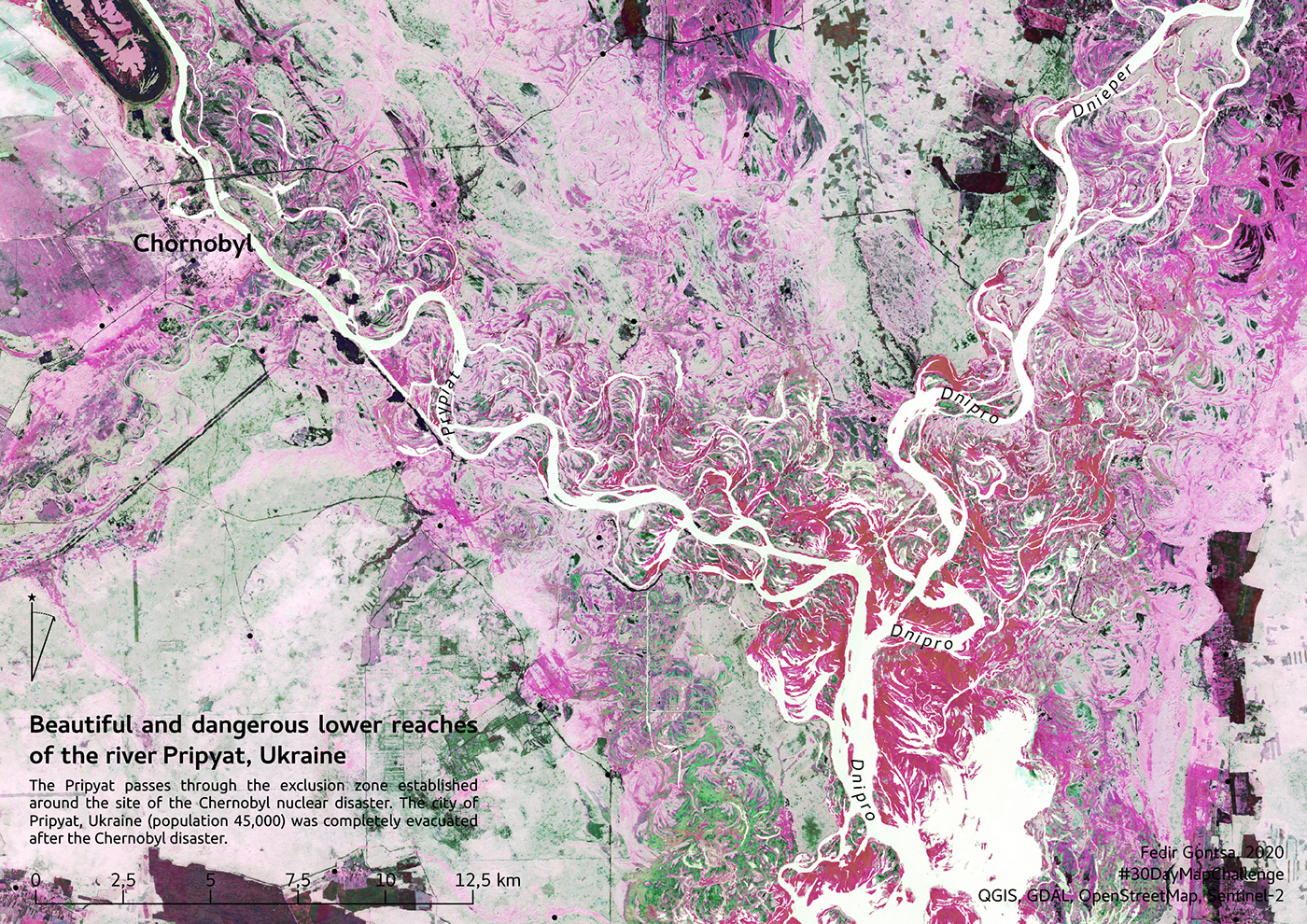
Day 21: Water
Beautiful and dangerous lower reaches of the river Pripyat, Ukraine
#30DayMapChallenge Day 21: Water
QGIS, GDAL, OpenStreetMap, Sentinel-2
https://twitter.com/gontsa/status/1330253374537785345
#30DayMapChallenge Day 21: Water
QGIS, GDAL, OpenStreetMap, Sentinel-2
https://twitter.com/gontsa/status/1330253374537785345
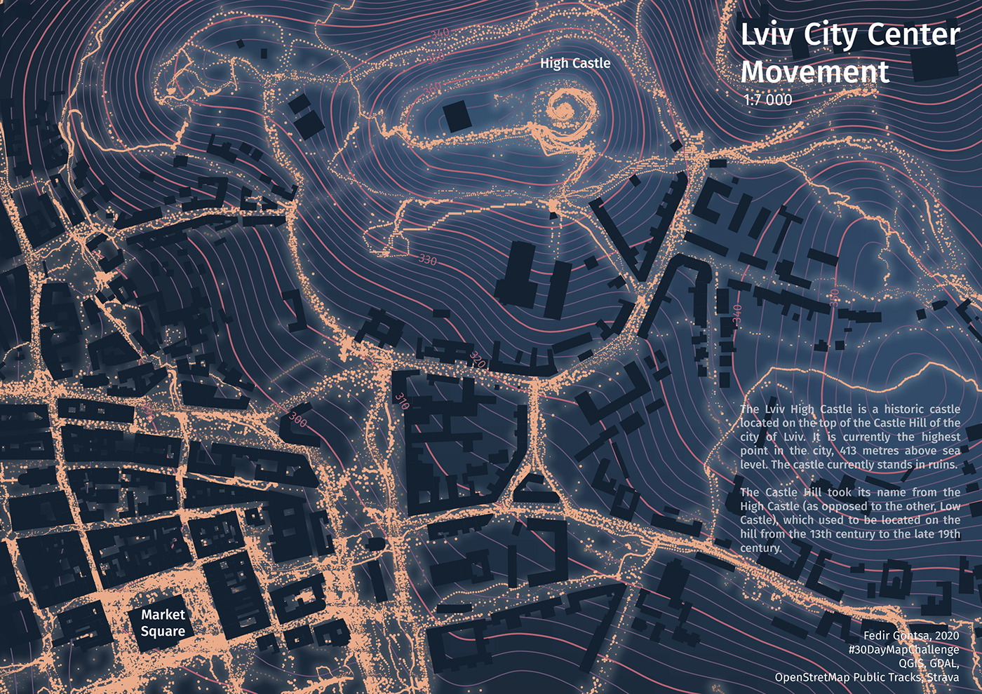
Day 22: Movement
Lviv (Ukraine) city center movement
#30DayMapChallenge Day 22: Movement
#QGIS GDAL, #OpenStreetMap, Strava tracks
https://twitter.com/gontsa/status/1330669585968881667
#30DayMapChallenge Day 22: Movement
#QGIS GDAL, #OpenStreetMap, Strava tracks
https://twitter.com/gontsa/status/1330669585968881667
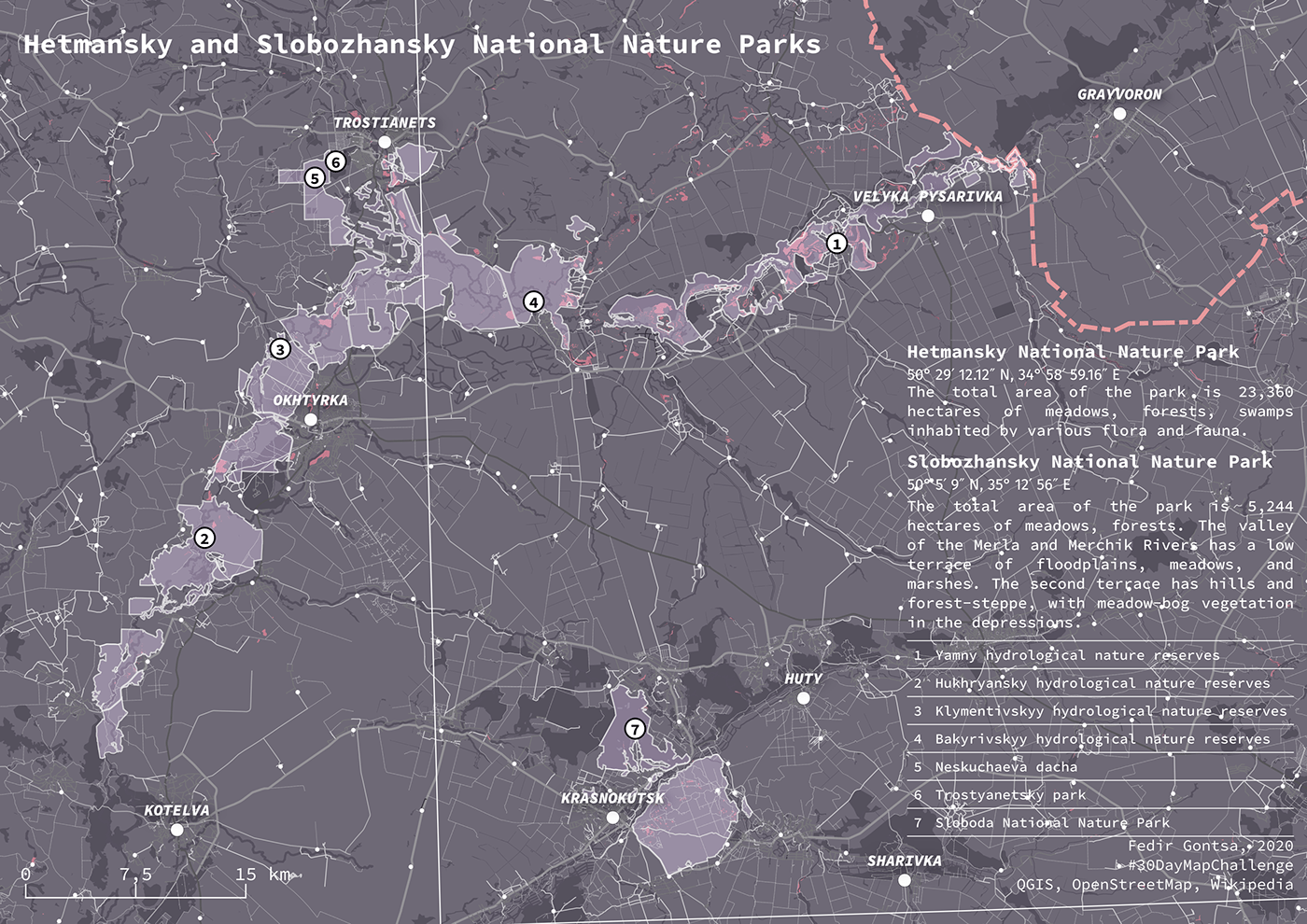
Day 23: Boundaries
Hetmansky and Slobozhansky National Nature Parks. Sumy and Kharkiv Oblast of Ukraine.
#30DayMapChallenge Day 23: Boundaries
#QGIS, #OpenStreetMap, #Wikipedia
https://twitter.com/gontsa/status/1331005810336550921
#30DayMapChallenge Day 23: Boundaries
#QGIS, #OpenStreetMap, #Wikipedia
https://twitter.com/gontsa/status/1331005810336550921
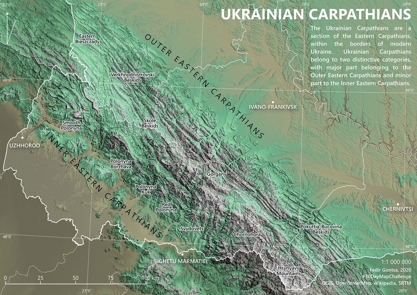
Day 24: Elevation
The Ukrainian Carpathians are a section of the Eastern Carpathians, within the borders of modern Ukraine. Ukrainian Carpathians belong to two distinctive categories, with major part belonging to the Outer Eastern Carpathians and minor part to the Inner Eastern Carpathians.
The Ukrainian Carpathians.
#30DayMapChallenge Day 24: Elevation
#QGIS, #OpenStreetMap, #Wikipedia, SRTM
https://twitter.com/gontsa/status/1331356421376643073
#30DayMapChallenge Day 24: Elevation
#QGIS, #OpenStreetMap, #Wikipedia, SRTM
https://twitter.com/gontsa/status/1331356421376643073
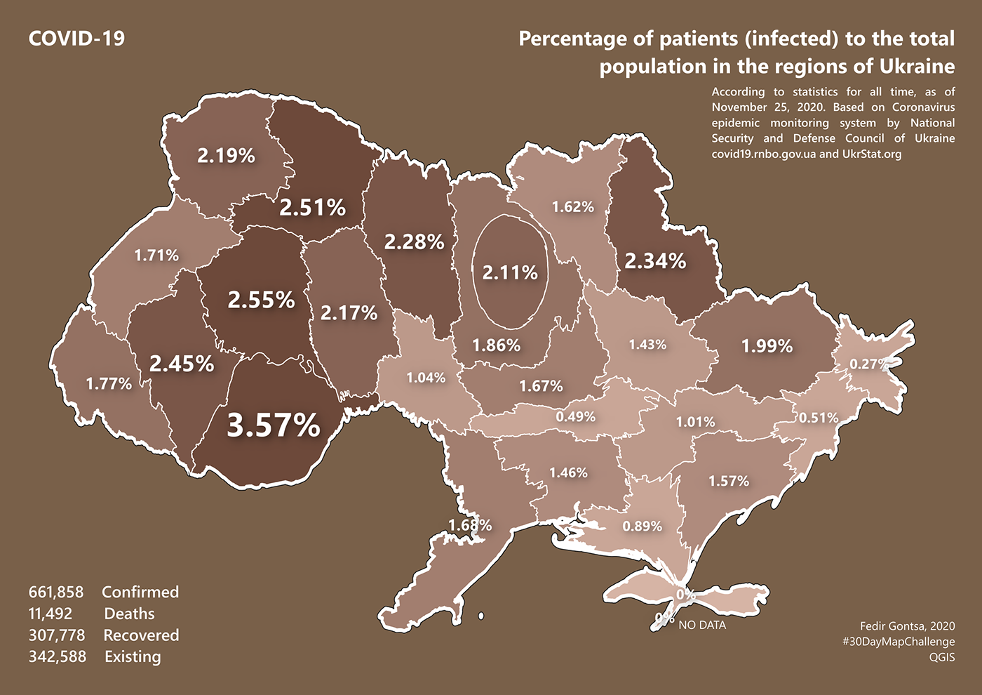
Day 25: COVID-19 (Cartogram)
Percentage of patients (infected) to the total population in the regions of Ukraine
#30DayMapChallenge Day 25: COVID-19
#QGIS, Data by National Security and Defense Council of Ukraine
https://twitter.com/gontsa/status/1331742881263087618
#30DayMapChallenge Day 25: COVID-19
#QGIS, Data by National Security and Defense Council of Ukraine
https://twitter.com/gontsa/status/1331742881263087618
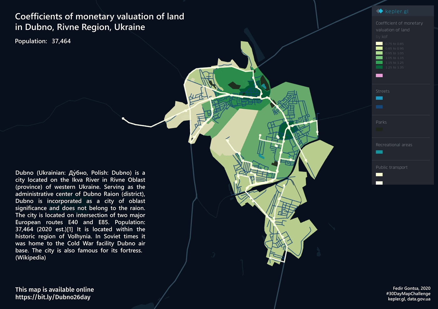
Day 26: Map with a new tool
Coefficients of monetary valuation of land in Dubno, Rivne Region, Ukraine.
#30DayMapChallenge Day 26: Map with a new tool
#kepler.gl, data.gov.ua
Online Map https://bit.ly/Dubno26day
https://twitter.com/gontsa/status/1332096830558101511
#30DayMapChallenge Day 26: Map with a new tool
#kepler.gl, data.gov.ua
Online Map https://bit.ly/Dubno26day
https://twitter.com/gontsa/status/1332096830558101511
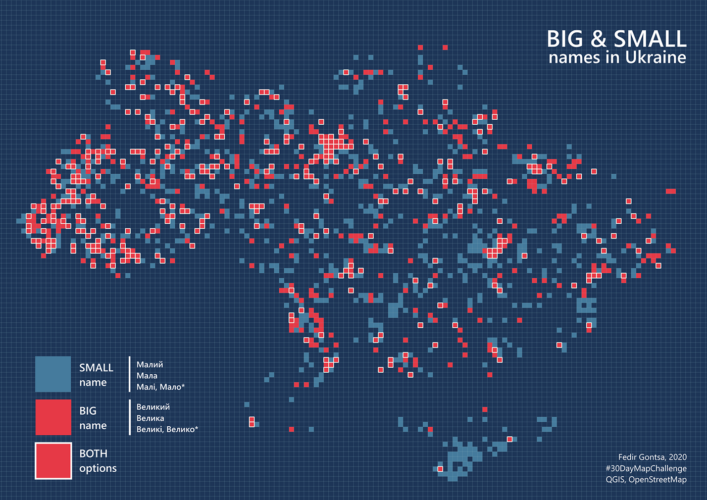
Day 27: Big or small data
Big and Small names in Ukraine. Big data for all names small cells for density :)
#30DayMapChallenge Day 27: Big or small data
#QGIS, #OpenStreetMap
https://twitter.com/gontsa/status/1332459258496102406
#30DayMapChallenge Day 27: Big or small data
#QGIS, #OpenStreetMap
https://twitter.com/gontsa/status/1332459258496102406

Day 28: Non-geographic map
Basic visual connections and compositional axes in park "Sofiyivka", Uman (Cherkasy region), Ukraine.
This is part of my research.
#30DayMapChallenge Day 28: Non-geographic map
#QGIS, #OpenStreetMap, Personal research
https://twitter.com/gontsa/status/1332819747398946823
#30DayMapChallenge Day 28: Non-geographic map
#QGIS, #OpenStreetMap, Personal research
https://twitter.com/gontsa/status/1332819747398946823
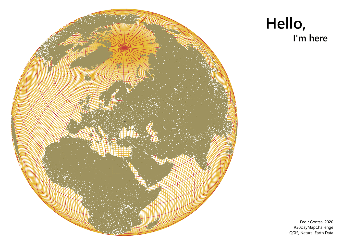
Day 29: Globe
Hello, I'm here.
#30DayMapChallenge Day 29: Globe
#QGIS, Natural Earth Data
https://twitter.com/gontsa/status/1333154624962965505
#30DayMapChallenge Day 29: Globe
#QGIS, Natural Earth Data
https://twitter.com/gontsa/status/1333154624962965505
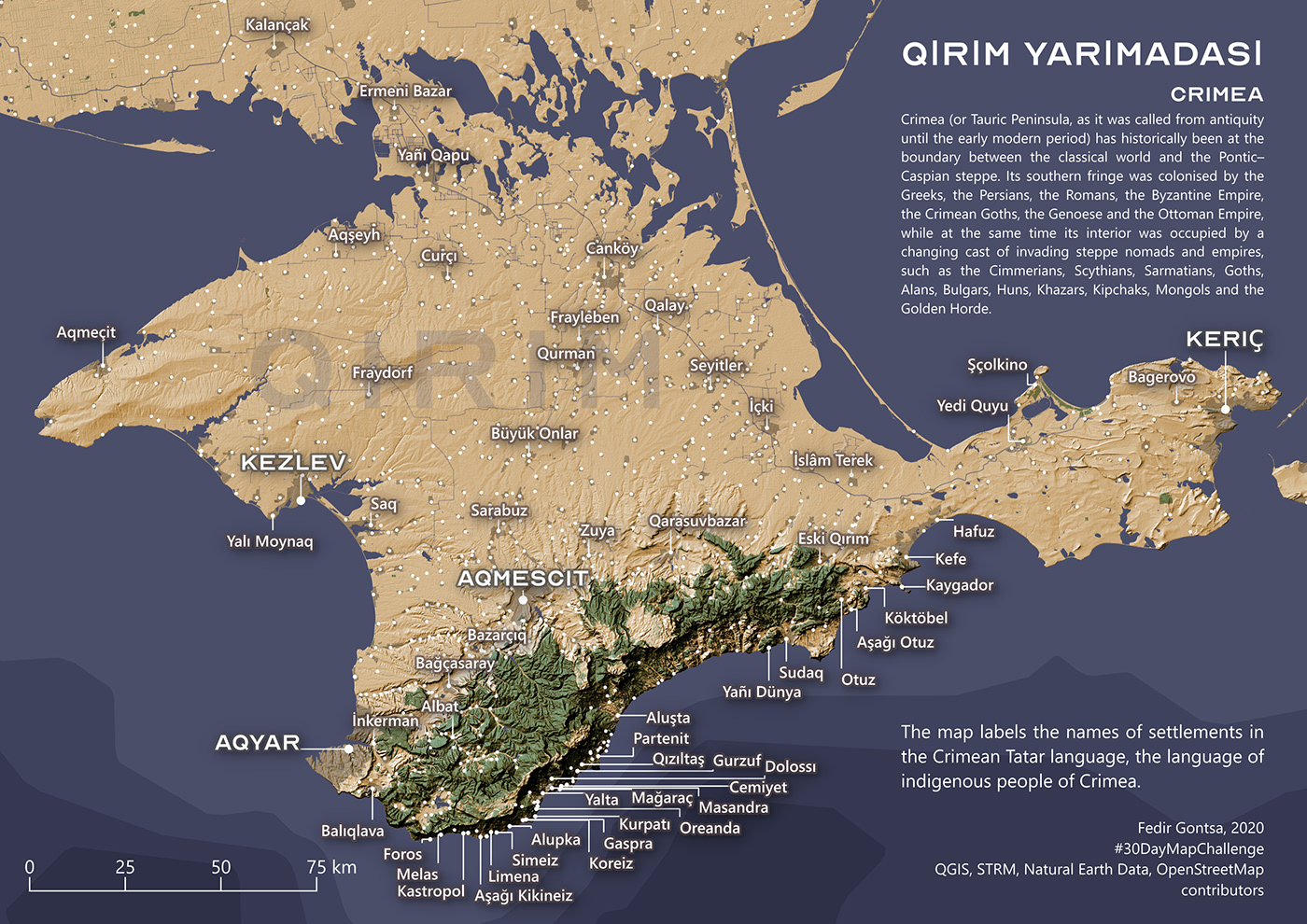
Day 30: A map
Crimea | Qırım
The map labels the names of settlements in the Crimean Tatar language, the language of indigenous people of Crimea.
#30DayMapChallenge Day 30: A map
#QGIS, STRM, Natural Earth Data, #OpenStreetMap contributors
https://twitter.com/gontsa/status/1333527390631432192
The map labels the names of settlements in the Crimean Tatar language, the language of indigenous people of Crimea.
#30DayMapChallenge Day 30: A map
#QGIS, STRM, Natural Earth Data, #OpenStreetMap contributors
https://twitter.com/gontsa/status/1333527390631432192
That's all!
Thanks for watching all my work
over this incredible month!
over this incredible month!


