This analysis investigates the attributes that make Pittsburgh’s South Side unique. Using GIS and other data, usual urban characteristics are mapped, such as land use, circulation, and figure/ground, in addition to some characteristics especially unique to the South Side, such as its topography, historical development, and the distribution of churches and bars. This expression of the South Side’s character is aided by vignettes showing the street- and city-scape, as well as a written description of the neighborhood’s development.
-CP 240, Fall 2012 Prof. Elizabeth MacDonald


(text from these pages is also farther below, much larger!)

A Brief History
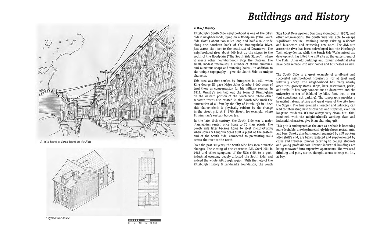
Pittsburgh’s South Side neighborhood is one of the city’s oldest neighborhoods, lying on an ancient floodplain (“The South Side Flats”) about two miles long and half a mile wide along the southern bank of the Monongahela River, just across the river to the southeast of Downtown. The neighborhood rises about 400 feet up the slopes to the south of the floodplain (“The South Side Slopes”), where it meets other neighborhoods atop the plateau. The small, modest rowhouses, a number of ethnic churches, and numerous shops and watering holes – in addition to the unique topography – give the South Side its unique character.
Pittsburgh’s South Side neighborhood is one of the city’s oldest neighborhoods, lying on an ancient floodplain (“The South Side Flats”) about two miles long and half a mile wide along the southern bank of the Monongahela River, just across the river to the southeast of Downtown. The neighborhood rises about 400 feet up the slopes to the south of the floodplain (“The South Side Slopes”), where it meets other neighborhoods atop the plateau. The small, modest rowhouses, a number of ethnic churches, and numerous shops and watering holes – in addition to the unique topography – give the South Side its unique character.
This area was first settled by Europeans in 1763 when King George III gave Major John Ormsby 3,000 acres of land there as compensation for his military service. In 1811, Ormsby’s son laid out the town of Birmingham on the western portion of the South Side. Three other separate towns also existed in the South Side until the annexation of all four by the City of Pittsburgh in 1872; this characteristic is physically evident by the change in the street grid at S. 17th Street, for example, where Birmingham’s eastern border lay.
In the late 19th century, the South Side was a major glassmaking center, once home to 76 glass plants. The South Side later became home to steel manufacturing when Jones & Laughlin Steel built a plant at the eastern end of the South Side, connected to preexisting mills across the river to the north.
Over the past 30 years, the South Side has seen dramatic changes. The closing of the enormous J&L Steel Mill in 1986 and other symptoms of the US’s shift to a post-industrial economy deeply affected the South Side, and indeed the whole Pittsburgh region. With the help of the Pittsburgh History & Landmarks Foundation, the South Side Local Development Company (founded in 1967), and other organizations, the South Side was able to escape significant decline, retaining many existing residents and businesses and attracting new ones. The J&L site across the river has been redeveloped into the Pittsburgh Technology Center, while the South Side Works mixed-use development has filled the mill site at the eastern end of the Flats. Other old buildings and former industrial sites have been remade into new homes and businesses as well.
The South Side is a great example of a vibrant and successful neighborhood. Housing is (or at least was) relatively cheap. The neighborhood has many nearby amenities: grocery stores, shops, bars, restaurants, parks, and trails. It has easy connections to downtown and the university center of Oakland by bike, foot, bus, or car (but sometimes not parking). The topography provides a beautiful natural setting and great views of the city from the Slopes. The fine-grained character and intricacy can lead to interesting new discoveries and surprises, even for longtime residents. It’s not always very clean, but this, combined with the neighborhood’s working class and industrial character, give it a charming grit.
This grit is endangered as the area as a whole is becoming more desirable, drawing increasingly hip shops, restaurants, and bars. Smoky dive bars, once frequented by mill workers after shift’s end, are being replaced and supplemented by clubs and trendier lounges catering to college students and young professionals. Former industrial buildings are being renovated into expensive apartments. The weekend drinking and party scene, though, seems to keep stirility at bay.
The South Side Flats
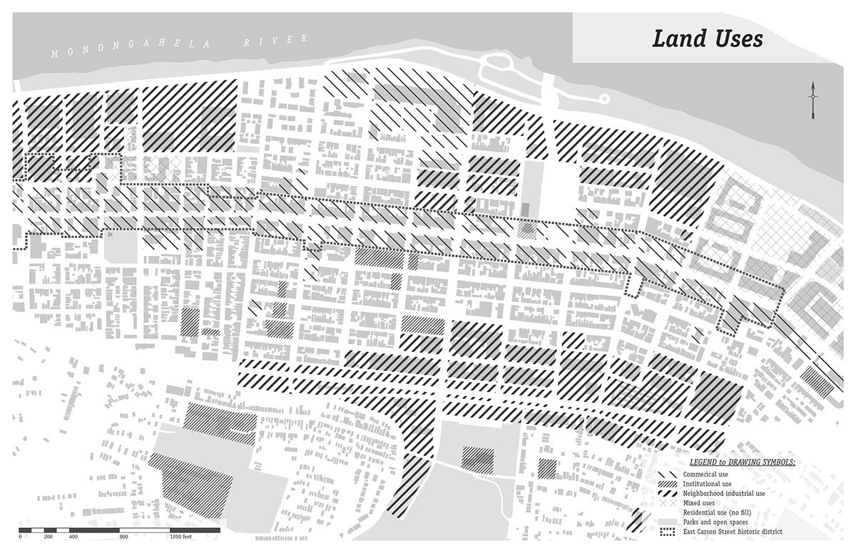
While portions of the Flats house light industrial and commercial uses, most of the area is residential. Most buildings are red brick, and generally range from two to four stories tall. Trees are found along a select number of roads, and a few are present in the interior of some blocks – in addition to a few scattered green spaces – but the Flats are otherwise largely devoid of greenery.
The South Side’s main thoroughfare, East Carson Street, runs through the center of the Flats. This corridor is now a National Historic District, being fairly well-preserved as the largest extant example of Victorian commercial architecture. While many have been poorly renovated over the years, more and more are being restored.
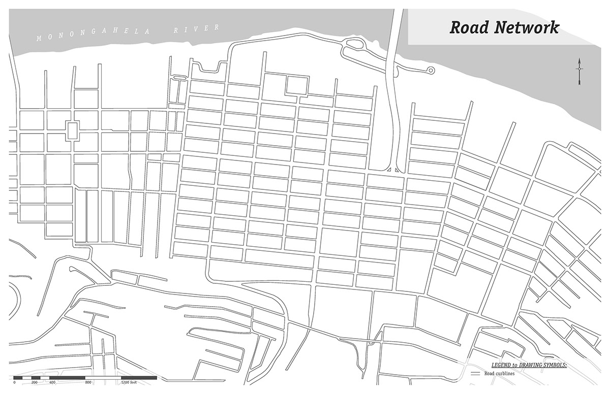
The somewhat irregular street grid on the Flats provides a dynamic experience along the streetscape. In the older portion of the neighborhood west of S. 17th Street, the streets are most narrow and irregular. A number of kinks in the roads contribute to interesting views. The bent but more regular grid east of S. 17th Street still provides interesting views thanks to the shifting of the grid as well as the topography. Street widths range from East Carson Street’s 80 feet, to the most common 60-foot street, to 24-foot alleyways.
Two railroads constrain the flats – one to the north, just past which lies a narrow but leafy riverfront park and trail; and one to the south at the foot of Slopes, elevated above grade with massive stone retaining walls. Along both railroad lines remain a number of buildings housing light industrial uses, as well as a couple small strip malls.
Some of these industrial areas are being converted, and are now home to new houses and mixed-use development. In the center of the southern edge of the Flats, near the railroad, stands the 10-story former Duquesne Brewery building, atop which is the world’s third-largest clock, measuring 60 feet in diameter. It is now painted bright orange, emblazoned with the letters a t & t.
The housing stock on the Flats mainly consists of rowhouses of varying styles, from handsome brick Victorians to tiny, vinyl-clad alley houses. The Flats are densely developed; houses typically range from 16 to 25 feet wide, and average about 50 feet deep. Most houses are two-and-a-half stories tall. While many houses directly abut their neighbors, many also have a two- or three-foot-wide path between them; the space between houses to the rear is tight as well, often 25 feet or less. All of this results in a typical row house density of about 20 units per acre. Almost every house has a small font stoop of three or four stairs, many of which are covered with aluminum awnings ubiquitous to such houses in Pittsburgh. A number of schools, churches, and other buildings repurposed as apartments add to the housing mix.
The South Side Slopes
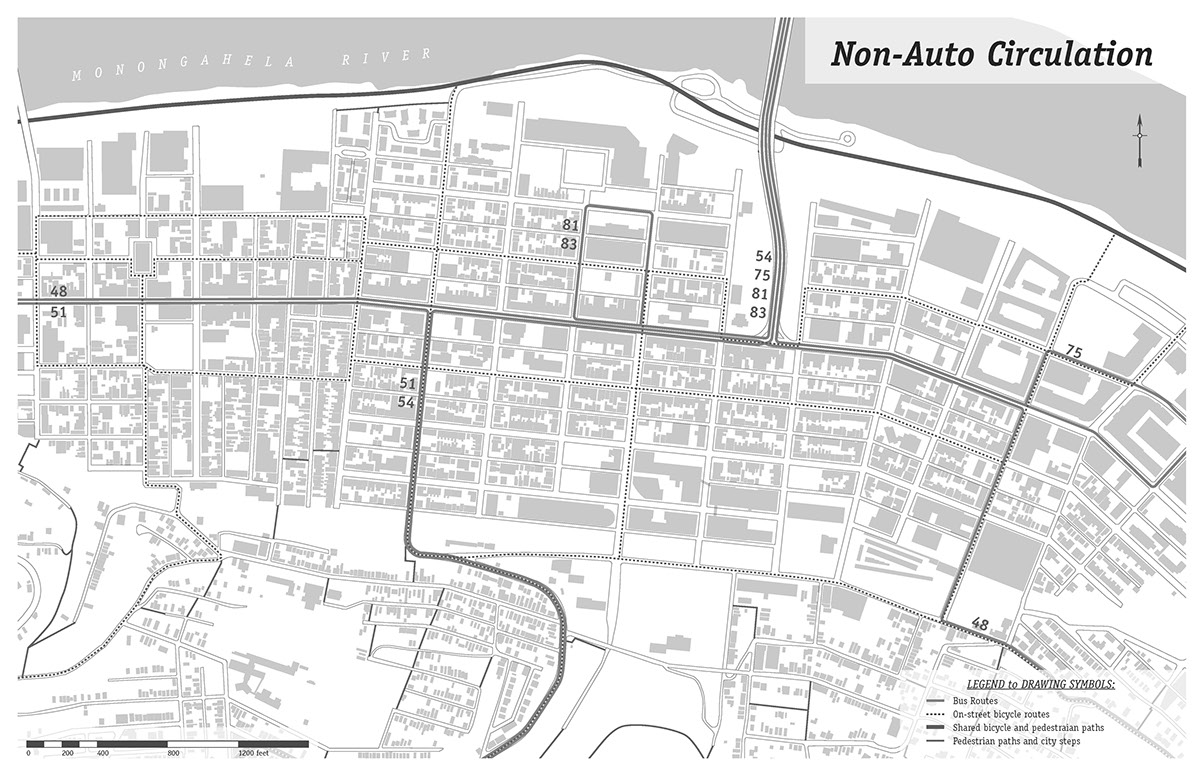
The South Side Slopes are home to hundreds of houses clinging precariously (and picturesquely) to the hillside. A park sits along a pair of ravines which bisect the neighborhood. Steep streets wind their way upward, supplemented by dozens of flights of city steps; a number of houses are accessible only by such staircases. At one time, four inclines (i.e. funiculars, with one exclusively for coal) also assisted in transport up the Slopes to the neighborhoods at top; the last one ceased operation in 1960.
While a few industrial buildings lie near the railroad line at the foot of the Slopes, the neighborhood is almost exclusively residential. Houses are similar to those on the flats, but more modest; nearly all are wood-framed, not brick. The steep landscape and lower desirability of the neighborhood allows for more space between houses. The resulting density is about half that on the flats: ten units per acre. Though the Slopes have not seen the level of investment their neighbors on Flats have recently experienced, increasing housing costs on the Flats, in addition to the great views, are starting to bring new residents to the Slopes.
Demographics and Housing
Though the population of the South Side as a whole has dropped to a quarter of its 1940s peak of over 40,000 people, the past decade has started to show improvements; as more students and young professionals have moved in, the median age has dropped by nearly a quarter over the last ten years, to 29.7 (compared to 33.2 citywide). In fact, the 20–34 year-old age group saw a 60% increase in population – this age group now constitutes over half of the residents in the South Side – while other age groups have experienced decreases. The number of family households has also dropped by nearly 30%. The area is 93% white, while the citywide population is 66% white and 26% black.
Neighborhood home values have jumped by nearly 50%; the South Side has had the greatest rate of home value appreciation in the city. (Interestingly, however, median inflation-adjusted income has stayed flat around $35,000 annually, about the citywide average.) A number of newly-constructed houses and apartments have resulted in a 28% increase in the number of households – but with the population only rising 3%, average household size has decreased as well. Sixty percent of residents are renters, up from 50% in 2000, and slightly higher compared to the citywide average of 52%. While a few new houses have been built as infill, most new units – including rowhouses and apartments – have been constructed in formerly industrial zones near the river.
Businesses
Meanwhile, the business climate in the South Side is strong. The number employed in the area has grown by 50% – largely thanks to new office space in the South Side Works (now home to the headquarters of American Eagle Outfitters) and annual inflation-adjusted payroll for
the area has grown by two-thirds. The largest employment sectors are Health Care and Social Assistance (likely driven by the University of Pittsburgh Medical Center) and, unsurprisingly, Accommodation and Foodservice.
Churches and Bars
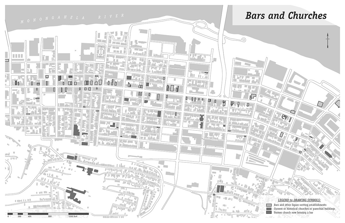
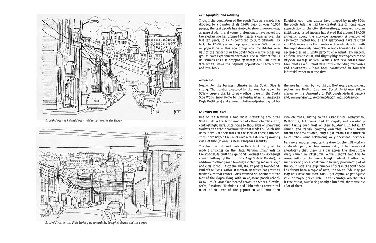
One of the features I find most interesting about the South Side is the large number of ethnic churches, and, contrastingly, bars. Once home to thousands of immigrant workers, the ethnic communities that made the South side home have left their mark in the form of these churches. These have helped the South Side retain its strong working class, ethnic (mainly Eastern European) identity.
One of the features I find most interesting about the South Side is the large number of ethnic churches, and, contrastingly, bars. Once home to thousands of immigrant workers, the ethnic communities that made the South side home have left their mark in the form of these churches. These have helped the South Side retain its strong working class, ethnic (mainly Eastern European) identity.
The first English and Irish settlers built many of the modest churches on the Flats. German immigrants in the mid-1800s built the grand St. Michael the Archangel church halfway up the hill (now Angel’s Arms Condos), in addition to other parish buildings including separate boys’ and girls’ schools. Atop the hill, Italian priests founded St. Paul of the Cross Passionist monastery, which has grown to include a retreat center. Poles founded St. Adalbert at the foot of the slopes along with an adjacent parish school, as well as St. Josephat located across the Slopes. Slovaks, Serbs, Russians, Ukrainians, and Lithuanians constituted much of the rest of the population and built their
own churches, adding to the established Presbyterian, Methodists, Lutherans, and Episcopals, and eventually even taking over most of their buildings. In total, 17 church and parish building ensembles remain today within the area studied; only eight retain their function as churches, some celebrating only occasional services.
Bars were another important feature for the mill workers of decades past, as they remain today. It has been said anecdotally that there is a bar across the street from every church in Pittsburgh. While I didn’t find this to consistently be the case (though, indeed, it often is), such watering holes continue to be very prominent part of the South Side. The large number of bars in the South Side has always been a topic of note; the South Side may (or may not) have the most bars – per capita, or per square mile, or maybe per church – in the country. Whether this is true or not, numbering nearly a hundred, there sure are a lot of them.
Bars were another important feature for the mill workers of decades past, as they remain today. It has been said anecdotally that there is a bar across the street from every church in Pittsburgh. While I didn’t find this to consistently be the case (though, indeed, it often is), such watering holes continue to be very prominent part of the South Side. The large number of bars in the South Side has always been a topic of note; the South Side may (or may not) have the most bars – per capita, or per square mile, or maybe per church – in the country. Whether this is true or not, numbering nearly a hundred, there sure are a lot of them.
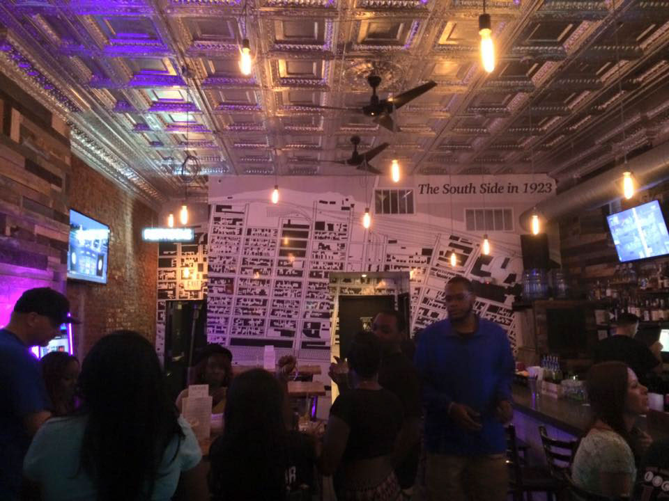
My graphics were so compelling they were blown up and affixed to the wall of a South Side bar (without my knowledge, and slightly off scale)