


Map Of Densification ''Sprawl''
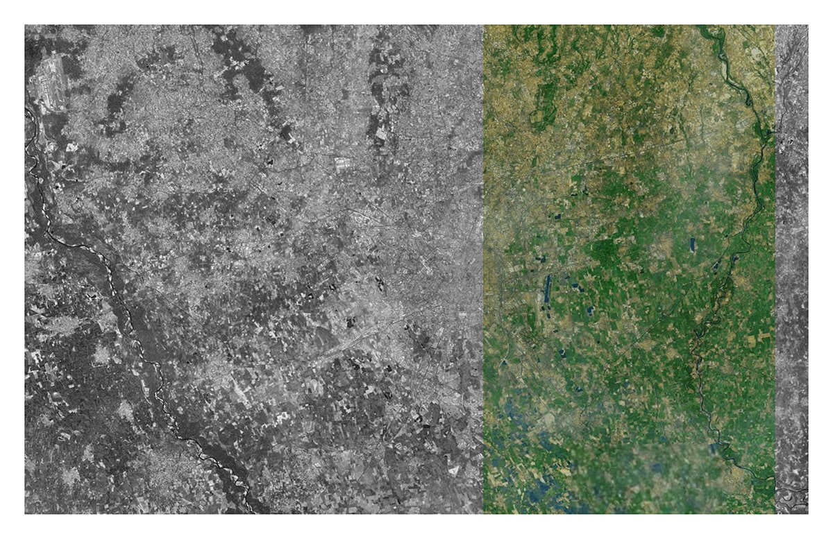
In this map we can see how the cities has sprawled In the last 50 where we can notice main expansion in the north, from fragmented to linear and north was always more dense Lombardia region is characterized by large, uncontrolled and rash land consumption.
In this map we can see how the cities has sprawled In the last 50 where we can notice main expansion in the north, from fragmented to linear and north was always more dense Lombardia region is characterized by large, uncontrolled and rash land consumption.
Resource: Colucci A., Belotti D., De Capitani G.,Land cover changes in Lombardy over the last 50 years, ERSAF, Regione Lombardia, 2012.

Mapping Fase: The Road.
Cities appears as non-compacted urban conglomerates, full of chaotic shapes, and functions.
Cities appears as non-compacted urban conglomerates, full of chaotic shapes, and functions.

The Industry
Heavy infrastructure and huge industry areas caused horrible landscape devastation.
Heavy infrastructure and huge industry areas caused horrible landscape devastation.
Historical areas:
where growing also with a connection with the roads.
where growing also with a connection with the roads.
Historical areas:
Historically influenced not only by road but also by rivers, canals, and the green areas.
Historically influenced not only by road but also by rivers, canals, and the green areas.
Between two lines/Localisation
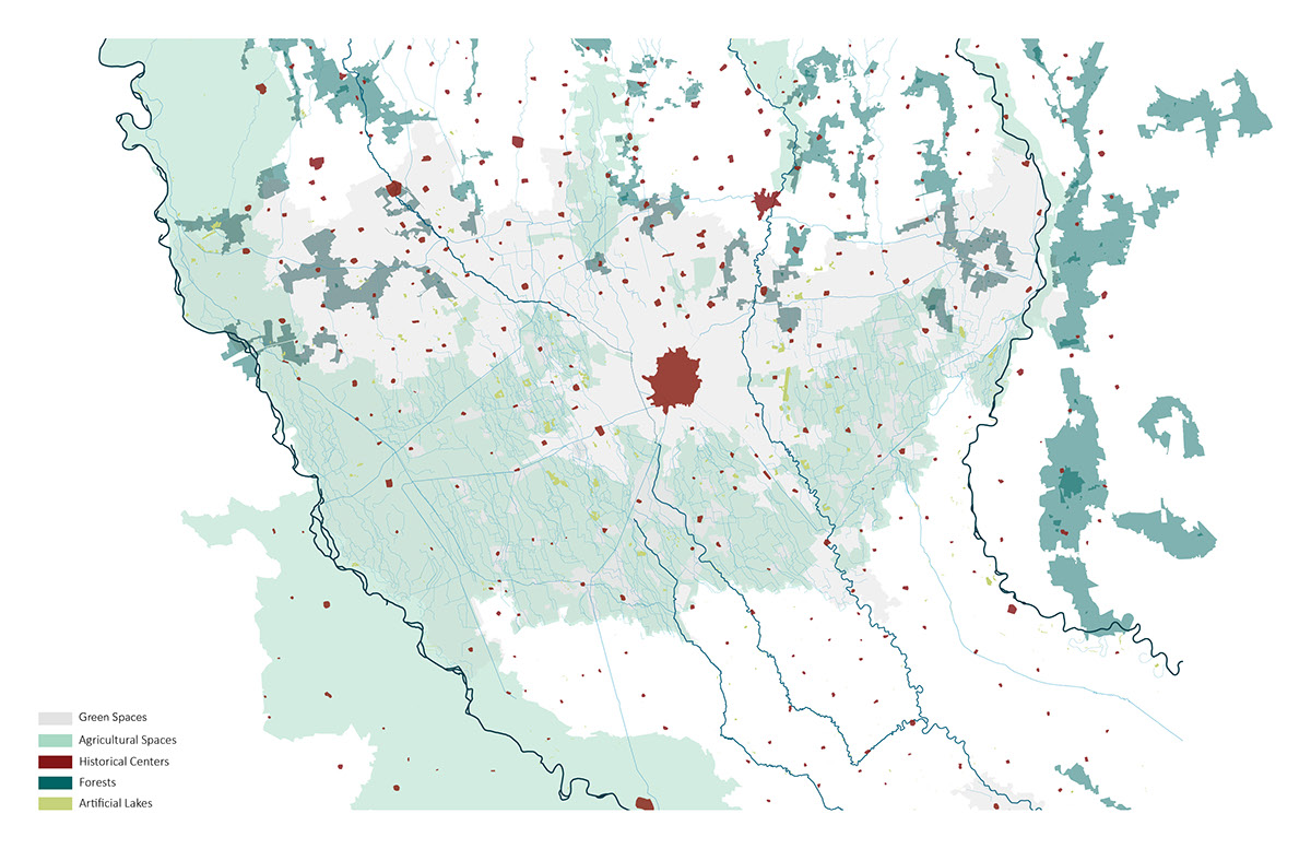
We can distinguish an extremely large number of different terrain characteristics of Lombardia region. In order to simplify the design process, we analyze a strip localized between the Adda and lambor river and we have divide it into two parts - north and south.This kind of distinction is caused by different characteristic of urban patterns that occurs there.
We can distinguish an extremely large number of different terrain characteristics of Lombardia region. In order to simplify the design process, we analyze a strip localized between the Adda and lambor river and we have divide it into two parts - north and south.This kind of distinction is caused by different characteristic of urban patterns that occurs there.

By analyzing the stripe we have divided the analysis into four types; two of them were about the environment '' water'' and '' greenery'', the other was about the relation between the fragments and all the elements to start identify the fragments as its identity. where those cities deal with several problems such as lack of identity, lack of program, thread of chaotic expansion.

Densification
From the very beginning, we focus on expansion and land consumption in order to prevent a future negative phenomenon. We were experimenting with different types of densification to establish a new model of growing that solve metropolitan area sprawl problems.
From the very beginning, we focus on expansion and land consumption in order to prevent a future negative phenomenon. We were experimenting with different types of densification to establish a new model of growing that solve metropolitan area sprawl problems.

Open space:
One of the reasons of excessive landscape devastation is weak identity of open space and generation of territory character in city growing process. Our strategy is focused to reinforce the role of the open space in city development. By reorganising boundaries of the cities.

STORY DESCRIPTION
Problems
Developed strategy focuses on two main problems of metropolitan area - big land consumption (mainly caused by chaotic expansion) and lack of identity (mainly caused by uniform size of cities and disconnection from surrounding natural elements).
Problems
Developed strategy focuses on two main problems of metropolitan area - big land consumption (mainly caused by chaotic expansion) and lack of identity (mainly caused by uniform size of cities and disconnection from surrounding natural elements).
Big scale The first part of the strategy refers to the relationship between different fragments. The aim of the first part is to provide diversity in fragment size and save open space continuation.
General approach
The General strategy came from analyzing basic methods of providing greenery to the city. We can consider the three main types: 1-urban belts,2- urban parks,3- green fingers
The General strategy came from analyzing basic methods of providing greenery to the city. We can consider the three main types: 1-urban belts,2- urban parks,3- green fingers
Mixing general approach
Each typology is suitable for different size of the city. By mixing typologies together we obtain several new typologies, adapted to cities with various sizes, localized in analyzed parts of the metropolitan area. By combining the ideas of Christopher Alexander and Leon Krier we established a new idealized model of the city growing process. To obtain It we use "distribution of towns", "city and country fingers" patterns from "Pattern Language" and L. Krier comparison "city growing process" to "family growing process" Our strategy transforms and adopts these basic rules and ideas to the existing situation in the Milano metropolitan area. This kind of system permits multiple scenarios of expansion and it is not trying to predict the form of future events in advance.
Each typology is suitable for different size of the city. By mixing typologies together we obtain several new typologies, adapted to cities with various sizes, localized in analyzed parts of the metropolitan area. By combining the ideas of Christopher Alexander and Leon Krier we established a new idealized model of the city growing process. To obtain It we use "distribution of towns", "city and country fingers" patterns from "Pattern Language" and L. Krier comparison "city growing process" to "family growing process" Our strategy transforms and adopts these basic rules and ideas to the existing situation in the Milano metropolitan area. This kind of system permits multiple scenarios of expansion and it is not trying to predict the form of future events in advance.
Small scale The second part of the strategy sets up a new process of expanding for fragments. The aim of the second part is to provide identity to the cities and reconfigure open spaces between them by creating new public spaces, reconfiguring boundaries and establishing new programs.
Priorities - order of expansion directions
1 reuse / rebuild abandoned industrial areas, 2 expanding inside - using vacant plots inside the city, 3 controlling expansion (expansion inside the group) - expansion of fragments is strictly focused to form a new group of cities with public open spaces and agricultural areas between them, 4 providing regularity - (expanded outside group) assuming expression in the way that corrects and regularizes shapes of the fragment.
1 reuse / rebuild abandoned industrial areas, 2 expanding inside - using vacant plots inside the city, 3 controlling expansion (expansion inside the group) - expansion of fragments is strictly focused to form a new group of cities with public open spaces and agricultural areas between them, 4 providing regularity - (expanded outside group) assuming expression in the way that corrects and regularizes shapes of the fragment.

Bad scenario :
scheme shows catastrophic consequences of urban expansion in the next 50 years if no regulation is provided. Uncontrolled fragmentation and expansion, increasing the level of porosity leads to disconnection of open space continuity and excessive land consumption.

A map which applied strategy shows a possible scenario of fragments development between the Adda and Lambro river. Several positive results of expansion that follows strategy can be seen: all open space continuity lines are saved, diversity in city size is provided, land consumption is controlled and level of sprawl is lowered, cities shapes are regulated. Strategy comprises several actions and principles. They can be used in different variations. Due to this characteristic, system is adaptable for regions with different characteristics - regardless of size of city, land form, the relationship between nearby cities or localization in the metropolitan area. Results of uncontrolled expansion can be prevented by several actions. By indicating direction of city expansion, we can obtain many positive results. First of all disconnection of open space continuity can be prevented, second of all diversity of city sizes can be introduced to this specific region. This also leads to improved identity of each fragment.
applying the Vision:
In the North: Reconfiguration of borders, protecting open space continuous regulation of shape.
In the North: Reconfiguration of borders, protecting open space continuous regulation of shape.
In the South: Establishing new relationships between cities, providing a diversity of city sizes, upgrading quality and the role of open spaces, preventing uncontrolled expansion, protecting continuity of open spaces, preventing landscape devastation.

Complex cities’ shape programs and relationship in the north require a unique solution. The strategy for this area consists of several actions mostly in small scale. In this area cities are big and spread. they are connected to each other, the boundaries between them are blurred and not specified. The cities are chaotic, uneven and unshapely. The main goal for this region is preventing uncontrolled expansion by indicating correct directions. This means to regulate shapes and to reconfigure borders.

Representation of applied strategy on north
In the north 3 of our priorities has been used. The view shows the development of the area in the north and the new configuration of the open space which is located through the fragments. The application is based on the densification of a part of the area and the design of a new bicycle and pedestrian line which follows the line of the nature already present in the territory. New open spaces and facilities will grow along this new line providing good quality of the green space and life
In the north 3 of our priorities has been used. The view shows the development of the area in the north and the new configuration of the open space which is located through the fragments. The application is based on the densification of a part of the area and the design of a new bicycle and pedestrian line which follows the line of the nature already present in the territory. New open spaces and facilities will grow along this new line providing good quality of the green space and life

Southren part of the region is covered witch smaller cities. They have clear boundaries and more regular shapes than cities in the north. Most of them have a historical center, however, they still deal, which several problems, such as lack of identity, lack of program, thread of chaotic expansion. In order to prevent land consumption and lack of identity, the strategy applied in this region works on both, big and small scale. In case of big scale, the strategy provides diversity in city sizes and tools to protect the open space continuity.
In smallest scale it increases, cities’ identity by providing: new relationship to surrounding natural elements, reconfiguration of open spaces, new public space with suitable program and slow mobility connections.

Representation of applied strategy on south
In the south we use all 4 priorities. The view shows the keeping of the open space between different fragments which are part of one of the new group of cities shown in the strategy for the south. The new way for slow mobility will develop along the river and will also provide the reuse of a part an industrial a banded area with the addition of new facilities and public spaces.
In the south we use all 4 priorities. The view shows the keeping of the open space between different fragments which are part of one of the new group of cities shown in the strategy for the south. The new way for slow mobility will develop along the river and will also provide the reuse of a part an industrial a banded area with the addition of new facilities and public spaces.

Paullo - Tribiano - Pantigliate - Caleppio
To test our strategy, we have chosen those four cities that are localized in the southern part of the strip. A lot of problems occur in this area, such as lack of identity, big industrial areas, meaningless open spaces, threat of chaotic expansion, complex relationship between administrative authorities and private interests and many more. On the other hand, those cities are an interesting example with a great opportunity to become meaningful local centers of great importance for the surrounding cities. The application of the strategy provides new relationship between cities and natural elements, where the strategy indicates directions of expansion considering the administrative borders as a tool to be democratic. However, the most important issue has been dealt with, is not providing development of the cities, but to develop in a way without destroying the landscape. Where the idea of developing is to create a concept that care about the open space in the city, moreover inside each expansion. The strategy considers the open spaces and the borders as an important point to be taken care of, where applying the strategy establish a new relationship between cities and surrounding open spaces by providing new public space with suitable program on the inner borders of the cities. In addition, the creation of a new system of slow mobility path will encourage the inhabitant to minimize the usage of cars; moreover the new bike line is not only creating connections between cities, but it is also giving the facility the possibility to connect the new open space that has been activated to each other, and also connect the existing facilities inside each city to each other, to create a new self-contained city.

Transept:
A transept has been chosen in this area to show a vision of the future city, By showing the strategy in the area and also by improving some point among the river "connection between industry and the river, the connection between river, bike line and a heritage casina’’ also the use of the vacant industrial area to create energy. In addition, some other point has been chosen where it shows the expansion strategy and the bike line path.

A section that shows the improvement point of connection '' Indutrial - river'' where energy point '' wind tolerant'' has been added

Section: A version of connection '' industrial- river''.. changing vacantindustrial areas to another function and putting a border of the river with creating bicycle line and pedestrian lines.

Section: vision of an expansion area, and connection with the bicycleline.

Section: A vision of the connection between pedestrian and bicycleline, with a casina that will be transformed to a heritage paints. orcultured one


